
Zir'in
Encyclopedia
Zir'in was a Palestinian
Arab
village of over 1,400 in the Jezreel Valley
, located 11 kilometres (6.8 mi) north of Jenin
. Identified as the Canaan
ite town of Yizre'el, it was known as Zir'in during Islamic rule, and was near the site of the Battle of Ain Jalut
, in which the Mamluk
s halted Mongol expansion southward. Under the Ottomans, it was a small village, expanding during the British Mandate in the early 20th century. After its capture by Israel
in 1948, Zir'in was destroyed.
ite town of Yizre'el mentioned by Joshua
in the Bible
. Yizre'el translates in Hebrew
as "God give seed", and the name was Arabicize
d into "Zir'in" following the Muslim conquest of Syria
in the 7th century CE.
After the Crusaders invaded the Levant
, they referred to it as "le Petit Gerin" or "the Little Jenin" to distinguish it from Jenin, which they called "le Grand Gerin". In Latin literature of the time it was called "Gezrael", "Iezrael", "Parvum Gerinum" or "Zarain". A vaulted building and other structures remain from a castle that belonged to the Templars by the 1180s. During the Battle of al-Fule
, Saladin
's sent skirmishers to raid then Crusader-held Zir'in in October 1183. In September 1184, Saladin and his Ayyubid forces passed through the village on their way to Nablus
.
After the Mamluk
s took control of the area in the late 13th century, the Mamluk sultan Zahir Baybars defeated the Mongols in the Battle of Ain Jalut
, at a site just west of Zir'in. After the battle, Baybars ordered the renovation of the village mosque
. During the Mamluk period the village was one of the stops on the postal route
between Jenin and Irbid
.
In 1517, Zir'in was incorporated into the Ottoman Empire
along with the rest of Palestine
, and by 1596 it was a part of the nahiya ("subdistrict") of Jinin, a part of Sanjak Lajjun
. A tiny village of four Muslim households, it paid taxes on wheat, barley, beehives, and goats. In the 17th and 18th centuries the village was most likely under the control of the Turabay, bedouin
amirs who ruled most of the area during this time. In the 19th century, Zir'in consisted of about thirty houses, with the most prominent family living in a tall, tower-like house in the village center. A spring and well supplied Zir'in with water. The Ottomans founded a boys' school in the village.
In the British Mandate period in the early 20th century, Zir'in was the birthplace of Mahmud Salim, a leader of the 1936-1939 Arab revolt in Palestine. The majority of its houses were constructed of mud and were clustered together, but house building and renovation also expanded. The commercial center of Zir'in consists of the Mosque of Baybars, a marketplace, and the Ottoman school. Residents mainly cultivated grains, fruits, and vegetables.
, in March 1948, Zir'in's defenders, the Arab Liberation Army
(ALA), reported that the Haganah
had attempted several times to capture the village, but their assaults were suspended for ten days after heavy losses. On April 19, Zir'in was briefly captured, and most of the village houses were ordered destroyed, while the remainder were to be used to accommodate Jewish troops.
Controlled by the ALA, Zir'in was located in a strategic commanding position overlooking the towns of Afula
and Baysan. The fear of Iraqi forces from Gesher
in the east and Jenin in the south to form a "spearhead" and capture the Baysan and Jezreel valleys convinced the Jews to take Zir'in. After a mortar barrage to soften it defense, the village was captured on May 28 by the Thirteenth Battalion of the Golani Brigade
with "little resistance". Women and children fled weeks prior to its capture, and after word had spread of its capture, the residents of nearby Nuris
and al-Mazar
also abandoned their villages. The ALA unsuccessfully attempted to recapture Zir'in two days later.
On July 10, the Iraqi Army
based in Jenin, intended to recapture the village, but were unable to break through Jewish lines, followed by another unsuccessful attempt on July 19, after the second truce of the war. The final armistice line was drawn just to the south of Zir'in.
Israel
established Yizra'el on the northwestern side of Zir'in.
(manzil) for travelers. A representative for the Palestine Antiquities Museum (PAM), mr Husseini, visited Zir'in in 1941, and noted: "S-E. of Church in a lane a part of a wall about 8m. long with two rough course
s of masonry...S. within house of Abdul Karim Abdul Hadi in an open yard more building foundations are visible to N. two medieval vaults known as el-Uqud."
Pringle believes the vaults are part of the destroyed Crusader castle, but according to Petersen, they could equally well be from the Mamluk time. Petersen, who inspected the place in 1994, notes that the appearance of the building indicate that it was constructed over a long period of time.
at its southern and western sides, with an average elevation of 100 metres (328.1 ft) above sea level. To the north and east was Wadi al-Jalut. Located 11 kilometres (6.8 mi) north of Jenin, it was the northernmost locality in the Jenin District, and alongside a lateral road linking two highways; one towards Jenin, the other towards Baysan.
Nearby localities included Nuris to the southeast, Sandala
to the south, Zububa
to the southwest, Sulam
to the north, and Qumya
to the northeast. In 1945, it consisted of 23,920 dunams. The majority of the village lands (20,964 dunams) were allocated for cereals, while the built-up area of Zir'in consisted of 81 dunams.
's population survey, Zir'in had a population of 1,420, an increase of roughly 1.5% since 1931. All of the inhabitants were Muslim
s. Refugee
s from Zir'in and their descendants numbered 10,116 in 1998.
Palestinian people
The Palestinian people, also referred to as Palestinians or Palestinian Arabs , are an Arabic-speaking people with origins in Palestine. Despite various wars and exoduses, roughly one third of the world's Palestinian population continues to reside in the area encompassing the West Bank, the Gaza...
Arab
Arab
Arab people, also known as Arabs , are a panethnicity primarily living in the Arab world, which is located in Western Asia and North Africa. They are identified as such on one or more of genealogical, linguistic, or cultural grounds, with tribal affiliations, and intra-tribal relationships playing...
village of over 1,400 in the Jezreel Valley
Jezreel Valley
-Etymology:The Jezreel Valley takes its name from the ancient city of Jezreel which was located on a low hill overlooking the southern edge of the valley, though some scholars think that the name of the city originates from the name of the clan which founded it, and whose existence is mentioned in...
, located 11 kilometres (6.8 mi) north of Jenin
Jenin
Jenin is the largest town in the Northern West Bank, and the third largest city overall. It serves as the administrative center of the Jenin Governorate and is a major agricultural center for the surrounding towns. In 2007, the city had a population of 120,004 not including the adjacent refugee...
. Identified as the Canaan
Canaan
Canaan is a historical region roughly corresponding to modern-day Israel, Palestine, Lebanon, and the western parts of Jordan...
ite town of Yizre'el, it was known as Zir'in during Islamic rule, and was near the site of the Battle of Ain Jalut
Battle of Ain Jalut
The Battle of Ain Jalut took place on 3 September 1260 between Mamluks and the Mongols in eastern Galilee, in the Jezreel Valley, not far from Ein Harod....
, in which the Mamluk
Mamluk
A Mamluk was a soldier of slave origin, who were predominantly Cumans/Kipchaks The "mamluk phenomenon", as David Ayalon dubbed the creation of the specific warrior...
s halted Mongol expansion southward. Under the Ottomans, it was a small village, expanding during the British Mandate in the early 20th century. After its capture by Israel
Israel
The State of Israel is a parliamentary republic located in the Middle East, along the eastern shore of the Mediterranean Sea...
in 1948, Zir'in was destroyed.
History
Zir'in is known as the CanaanCanaan
Canaan is a historical region roughly corresponding to modern-day Israel, Palestine, Lebanon, and the western parts of Jordan...
ite town of Yizre'el mentioned by Joshua
Joshua
Joshua , is a minor figure in the Torah, being one of the spies for Israel and in few passages as Moses's assistant. He turns to be the central character in the Hebrew Bible's Book of Joshua...
in the Bible
Bible
The Bible refers to any one of the collections of the primary religious texts of Judaism and Christianity. There is no common version of the Bible, as the individual books , their contents and their order vary among denominations...
. Yizre'el translates in Hebrew
Hebrew language
Hebrew is a Semitic language of the Afroasiatic language family. Culturally, is it considered by Jews and other religious groups as the language of the Jewish people, though other Jewish languages had originated among diaspora Jews, and the Hebrew language is also used by non-Jewish groups, such...
as "God give seed", and the name was Arabicize
Arabization
Arabization or Arabisation describes a growing cultural influence on a non-Arab area that gradually changes into one that speaks Arabic and/or incorporates Arab culture...
d into "Zir'in" following the Muslim conquest of Syria
Muslim conquest of Syria
The Muslim conquest of Syria occurred in the first half of the 7th century, and refers to the region known as the Bilad al-Sham, the Levant, or Greater Syria...
in the 7th century CE.
After the Crusaders invaded the Levant
Levant
The Levant or ) is the geographic region and culture zone of the "eastern Mediterranean littoral between Anatolia and Egypt" . The Levant includes most of modern Lebanon, Syria, Jordan, Israel, the Palestinian territories, and sometimes parts of Turkey and Iraq, and corresponds roughly to the...
, they referred to it as "le Petit Gerin" or "the Little Jenin" to distinguish it from Jenin, which they called "le Grand Gerin". In Latin literature of the time it was called "Gezrael", "Iezrael", "Parvum Gerinum" or "Zarain". A vaulted building and other structures remain from a castle that belonged to the Templars by the 1180s. During the Battle of al-Fule
Battle of Al-Fule (1183)
In the campaign and Battle of Al-Fule, a Crusader force led by Guy of Lusignan skirmished with Saladin's Ayyubid army for more than a week in September 1183. Tactically the battle was a draw, but the Crusaders prevented Saladin from capturing any strongholds and caused him to retreat...
, Saladin
Saladin
Ṣalāḥ ad-Dīn Yūsuf ibn Ayyūb , better known in the Western world as Saladin, was an Arabized Kurdish Muslim, who became the first Sultan of Egypt and Syria, and founded the Ayyubid dynasty. He led Muslim and Arab opposition to the Franks and other European Crusaders in the Levant...
's sent skirmishers to raid then Crusader-held Zir'in in October 1183. In September 1184, Saladin and his Ayyubid forces passed through the village on their way to Nablus
Nablus
Nablus is a Palestinian city in the northern West Bank, approximately north of Jerusalem, with a population of 126,132. Located in a strategic position between Mount Ebal and Mount Gerizim, it is the capital of the Nablus Governorate and a Palestinian commercial and cultural center.Founded by the...
.
After the Mamluk
Mamluk
A Mamluk was a soldier of slave origin, who were predominantly Cumans/Kipchaks The "mamluk phenomenon", as David Ayalon dubbed the creation of the specific warrior...
s took control of the area in the late 13th century, the Mamluk sultan Zahir Baybars defeated the Mongols in the Battle of Ain Jalut
Battle of Ain Jalut
The Battle of Ain Jalut took place on 3 September 1260 between Mamluks and the Mongols in eastern Galilee, in the Jezreel Valley, not far from Ein Harod....
, at a site just west of Zir'in. After the battle, Baybars ordered the renovation of the village mosque
Mosque
A mosque is a place of worship for followers of Islam. The word is likely to have entered the English language through French , from Portuguese , from Spanish , and from Berber , ultimately originating in — . The Arabic word masjid literally means a place of prostration...
. During the Mamluk period the village was one of the stops on the postal route
Postal history of Palestine
The postage stamps and postal history of Palestine emerges out of its geographic location as a crossroads amidst the empires of the ancient Near East, the Levant and the Middle East...
between Jenin and Irbid
Irbid
Irbid , known in ancient times as Arabella or Arbela , is the capital and largest city of the Irbid Governorate. It also has the second largest metropolitan population in Jordan after Amman, with a population of around 660,000, and is located about 70 km north of Amman on the northern ridge of...
.
In 1517, Zir'in was incorporated into the Ottoman Empire
Ottoman Empire
The Ottoman EmpireIt was usually referred to as the "Ottoman Empire", the "Turkish Empire", the "Ottoman Caliphate" or more commonly "Turkey" by its contemporaries...
along with the rest of Palestine
Palestine
Palestine is a conventional name, among others, used to describe the geographic region between the Mediterranean Sea and the Jordan River, and various adjoining lands....
, and by 1596 it was a part of the nahiya ("subdistrict") of Jinin, a part of Sanjak Lajjun
Lajjun
Lajjun was a Palestinian Arab village of nearly 1,300 people located northwest of Jenin. The village along with nearby Umm al-Fahm and seven hamlets, had a total land area of 77,242 dunams or , of which were built-up, while the rest was used for agricultural purposes...
. A tiny village of four Muslim households, it paid taxes on wheat, barley, beehives, and goats. In the 17th and 18th centuries the village was most likely under the control of the Turabay, bedouin
Bedouin
The Bedouin are a part of a predominantly desert-dwelling Arab ethnic group traditionally divided into tribes or clans, known in Arabic as ..-Etymology:...
amirs who ruled most of the area during this time. In the 19th century, Zir'in consisted of about thirty houses, with the most prominent family living in a tall, tower-like house in the village center. A spring and well supplied Zir'in with water. The Ottomans founded a boys' school in the village.
In the British Mandate period in the early 20th century, Zir'in was the birthplace of Mahmud Salim, a leader of the 1936-1939 Arab revolt in Palestine. The majority of its houses were constructed of mud and were clustered together, but house building and renovation also expanded. The commercial center of Zir'in consists of the Mosque of Baybars, a marketplace, and the Ottoman school. Residents mainly cultivated grains, fruits, and vegetables.
1948 War
Prior to the 1948 Arab-Israeli War1948 Arab-Israeli War
The 1948 Arab–Israeli War, known to Israelis as the War of Independence or War of Liberation The war commenced after the termination of the British Mandate for Palestine and the creation of an independent Israel at midnight on 14 May 1948 when, following a period of civil war, Arab armies invaded...
, in March 1948, Zir'in's defenders, the Arab Liberation Army
Arab Liberation Army
The Arab Liberation Army , also translated as Arab Salvation Army, was an army of volunteers from Arab countries led by Fawzi al-Qawuqji...
(ALA), reported that the Haganah
Haganah
Haganah was a Jewish paramilitary organization in what was then the British Mandate of Palestine from 1920 to 1948, which later became the core of the Israel Defense Forces.- Origins :...
had attempted several times to capture the village, but their assaults were suspended for ten days after heavy losses. On April 19, Zir'in was briefly captured, and most of the village houses were ordered destroyed, while the remainder were to be used to accommodate Jewish troops.
Controlled by the ALA, Zir'in was located in a strategic commanding position overlooking the towns of Afula
Afula
Afula is a city in the North District of Israel, often known as the "Capital of the Valley", referring to the Jezreel Valley. The city had a population of 40,500 at the end of 2009.-History:...
and Baysan. The fear of Iraqi forces from Gesher
Gesher
Gesher , officially Gesher - National Social Movement was a political party in Israel between 1996 and 2003.-Foundation:Gesher was set up by David Levy on 11 March 1996 as a breakaway from the Likud party during the thirteenth Knesset, after he lost the Likud leadership elections to Binyamin...
in the east and Jenin in the south to form a "spearhead" and capture the Baysan and Jezreel valleys convinced the Jews to take Zir'in. After a mortar barrage to soften it defense, the village was captured on May 28 by the Thirteenth Battalion of the Golani Brigade
Golani Brigade
The Golani Brigade is an Israeli infantry brigade that is subordinated to the 36th Division and traditionally associated with the Northern Command. Its symbol is a green tree on a yellow background, and its soldiers wear a brown beret. It is one of the most highly decorated infantry units in the...
with "little resistance". Women and children fled weeks prior to its capture, and after word had spread of its capture, the residents of nearby Nuris
Nuris
Nuris was a Palestinian Arab village in the District of Jenin. It was depopulated during the 1948 War on May 29, 1948 under Operation Gideon.-Location:...
and al-Mazar
Al-Mazar, Jenin
Al-Mazar was a Palestinian Arab village in the District of Jenin. Situated on Mount Gilboa, its history stretched back to the period of Mamluk rule over Palestine . An agricultural village, it was depopulated during the 1948 Palestine War, and incorporated into the newly established State of Israel...
also abandoned their villages. The ALA unsuccessfully attempted to recapture Zir'in two days later.
On July 10, the Iraqi Army
Iraqi Army
The Iraqi Army is the land component of the Iraqi military, active in various forms since being formed by the British during their mandate over the country after World War I....
based in Jenin, intended to recapture the village, but were unable to break through Jewish lines, followed by another unsuccessful attempt on July 19, after the second truce of the war. The final armistice line was drawn just to the south of Zir'in.
Israel
Israel
The State of Israel is a parliamentary republic located in the Middle East, along the eastern shore of the Mediterranean Sea...
established Yizra'el on the northwestern side of Zir'in.
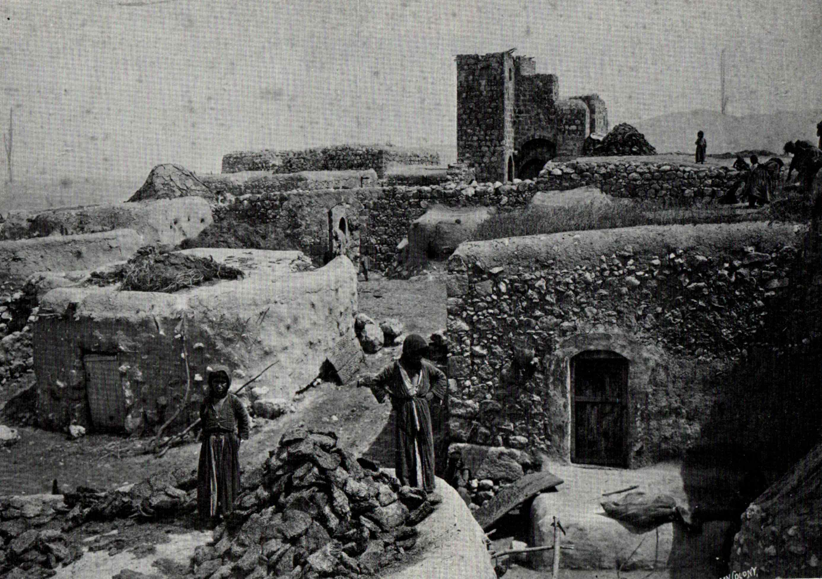
The tower house
In the 19th century this was described as the Castle of Zir'in, which was used as an innINN
InterNetNews is a Usenet news server package, originally released by Rich Salz in 1991, and presented at the Summer 1992 USENIX conference in San Antonio, Texas...
(manzil) for travelers. A representative for the Palestine Antiquities Museum (PAM), mr Husseini, visited Zir'in in 1941, and noted: "S-E. of Church in a lane a part of a wall about 8m. long with two rough course
Course (architecture)
A course is a continuous horizontal layer of similarly-sized building material one unit high, usually in a wall. The term is almost always used in conjunction with unit masonry such as brick, cut stone, or concrete masonry units .-Styles:...
s of masonry...S. within house of Abdul Karim Abdul Hadi in an open yard more building foundations are visible to N. two medieval vaults known as el-Uqud."
Pringle believes the vaults are part of the destroyed Crusader castle, but according to Petersen, they could equally well be from the Mamluk time. Petersen, who inspected the place in 1994, notes that the appearance of the building indicate that it was constructed over a long period of time.
Geography
Situated on a plateau off the Mount Gilboa, Zir'in was not much higher than the surrounding Jezreel ValleyJezreel Valley
-Etymology:The Jezreel Valley takes its name from the ancient city of Jezreel which was located on a low hill overlooking the southern edge of the valley, though some scholars think that the name of the city originates from the name of the clan which founded it, and whose existence is mentioned in...
at its southern and western sides, with an average elevation of 100 metres (328.1 ft) above sea level. To the north and east was Wadi al-Jalut. Located 11 kilometres (6.8 mi) north of Jenin, it was the northernmost locality in the Jenin District, and alongside a lateral road linking two highways; one towards Jenin, the other towards Baysan.
Nearby localities included Nuris to the southeast, Sandala
Sandala, Israel
Sandala is an Arab village in the North District of Israel. Located near Afula, it falls under the jurisdiction of Gilboa Regional Council. In 2006 it had a population of 1,500.-History:...
to the south, Zububa
Zububa
Zububa is a Palestinian village in the West Bank, located 10 km Northwest of the city of Jenin in the northern West Bank. According to the Palestinian Central Bureau of Statistics, the town had a population of 2,124 inhabitants in mid-year 2006....
to the southwest, Sulam
Sulam
Sulam is an Arab village in north-eastern Israel. Known in ancient times as Shunama and Shunem, it is first mentioned in the Amarna Letters in the 14th century BCE. Archaeological excavations in the village attest to habitation extending from the Bronze Age through to modern times. Located near...
to the north, and Qumya
Qumya
Qumya was a Palestinian village of 510 inhabitants when it was depopulated prior to the 1948 Arab-Israeli war.Located 12.5 kilometers north of Baysan, the village was assaulted by the forces of the Golani Brigade on 26 March 1948 during Operation Gideon, on the orders of Yosef Weitz, a...
to the northeast. In 1945, it consisted of 23,920 dunams. The majority of the village lands (20,964 dunams) were allocated for cereals, while the built-up area of Zir'in consisted of 81 dunams.
Demographics
Zir'in had a population 22 in 1596 according to Ottoman records. In 1922, a British Mandate survey recorded a population of 722, rising to 978 in the 1931 census. According to Sami HadawiSami Hadawi
Sami Hadawi was a Palestinian scholar and author. He is known for documenting the effects of the 1948 Arab-Israeli War on the Arab population in Palestine and published statistics for individual villages prior to Israel's establishment. Hadawi worked as a land specialist until he was exiled from...
's population survey, Zir'in had a population of 1,420, an increase of roughly 1.5% since 1931. All of the inhabitants were Muslim
Muslim
A Muslim, also spelled Moslem, is an adherent of Islam, a monotheistic, Abrahamic religion based on the Quran, which Muslims consider the verbatim word of God as revealed to prophet Muhammad. "Muslim" is the Arabic term for "submitter" .Muslims believe that God is one and incomparable...
s. Refugee
Palestinian refugee
Palestinian refugees or Palestine refugees are the people and their descendants, predominantly Palestinian Arabic-speakers, who fled or were expelled from their homes during and after the 1948 Palestine War, within that part of the British Mandate of Palestine, that after that war became the...
s from Zir'in and their descendants numbered 10,116 in 1998.
External links
- Welcome to Zir'in
- Zir'in at Khalil Sakakini Cultural CenterKhalil Sakakini Cultural CenterKhalil Sakakini Cultural Center is an organization established in 1996. It is located at 4 Raja Street, Ramallah in the West Bank. The traditional manor that houses the centre was the former family home of Khalil Salem Salah, the mayor of Ramallah between 1947/1951, is now owned by the Palestinian...
- Zir'in by Rami Nashashibi (1996), Center for Research and Documentation of Palestinian Society.
- Zir'in, circa 1900