

Ziller
Encyclopedia
Inn River
The Inn is a river in Switzerland, Austria and Germany. It is a right tributary of the Danube and is approximately 500km long. The highest point of its drainage basin is the summit of Piz Bernina, at 4,049 metres.- Geography :...
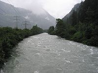
, in the Zillertal
Zillertal
The Zillertal is the biggest valley branching off the Inn valley in Tyrol, Austria drained by the river Ziller. It is surrounded by the strongly glaciated Zillertal Alps to the south and east, the lower grass peaks of the Kitzbühel Alps to the east and Tux Alps to the west...
in Tyrol
Tyrol (state)
Tyrol is a state or Bundesland, located in the west of Austria. It comprises the Austrian part of the historical region of Tyrol.The state is split into two parts–called North Tyrol and East Tyrol–by a -wide strip of land where the state of Salzburg borders directly on the Italian province of...
, Austria
Austria
Austria , officially the Republic of Austria , is a landlocked country of roughly 8.4 million people in Central Europe. It is bordered by the Czech Republic and Germany to the north, Slovakia and Hungary to the east, Slovenia and Italy to the south, and Switzerland and Liechtenstein to the...
. It springs from the ridge of the Zillertal Alps
Zillertal Alps
The Zillertal Alps are a mountain range of the Central Eastern Alps on the border of Austria and Italy. The range is named after the Zillertal on its north....
, and feeds the Zillergründl Dam
Zillergründl Dam
The Zillergründl Dam is an arch dam on the Ziller River in the upper Ziller Valley of Tyrol state, Austria. It is east of Mayrhofen. The primary purpose of the dam is hydroelectric power production and it supports a 360 MW pumped-storage power station...
. In Mayrhofen
Mayrhofen
- Twin towns : Chur, Switzerland Bad Tölz, Germany Bad Homburg, Germany Terracina, Italy Cabourg, France Bad Mondorf, Luxembourg- Transport :Mayrhofen has one railway station, which is located next to the Zillertaler Bundestrasse. The station is a terminus for all Train services operated by the...
it receives the Zemmbach (that in turn receives the Tuxerbach). By Zell am Ziller
Zell am Ziller
Zell am Ziller is a municipality in the Schwaz district of Tyrol, Austria. The name derives from the river Ziller.- Facilities :The Zillertal Arena was formed in 2000 from a merger of the ski areas of Zell, Gerlos and Königsleiten and is the largest ski area in the Ziller valley...
it receives the Gerlosbach, before it flows into the Inn by Strass im Zillertal
Strass im Zillertal
Strass im Zillertal is a municipality in the Schwaz district of Tyrol, Austria....
.
For historical reasons, the Ziller for most of its course makes up the border between the Diocese of Innsbruck
Roman Catholic Diocese of Innsbruck
The Diocese of Innsbruck is a diocese located in the city of Innsbruck in the Ecclesiastical province of Salzburg in Austria.-History:* December 11, 1925: Established as Apostolic Administration of Innsbruck – Feldkirch...
on the west and the Archdiocese of Salzburg
Roman Catholic Archdiocese of Salzburg
The Roman Catholic Archdiocese of Salzburg is an archdiocese of the Latin Rite of the Roman Catholic Church in Austria. The archdiocese is one of two Austrian archdioceses, serving alongside the Archdiocese of Vienna....
on the east. The Ziller today shows a good presence of brown
Brown trout
The brown trout and the sea trout are fish of the same species....
- and rainbow trout
Rainbow trout
The rainbow trout is a species of salmonid native to tributaries of the Pacific Ocean in Asia and North America. The steelhead is a sea run rainbow trout usually returning to freshwater to spawn after 2 to 3 years at sea. In other words, rainbow trout and steelhead trout are the same species....
, as well as grayling
Grayling (species)
The grayling is a species of freshwater fish in the salmon family of order Salmoniformes. It is the type species of its genus. Native to the Palearctic ecozone, the grayling is widespread throughout northern Europe, from the United Kingdom and France to the Ural Mountains in Russia...
. It is up to 20 m wide and 2 m deep, and it has an average discharge of 43.1 m³/s.