

Zagore Beach
Encyclopedia
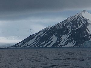
False Bay, Livingston Island
False Bay is a 4 mi long bay, which lies between Barnard Point and Miers Bluff on the south side of Livingston Island, in the South Shetland Islands, Antarctica. It was probably first entered and charted by Capt...
on Livingston Island, Antarctica and extends for 4 km on the Rozhen Peninsula
Rozhen Peninsula
Rozhen Peninsula extends 9 km in the southwest direction towards Barnard Point, Livingston Island in the South Shetland Islands, Antarctica, and 8.8 km wide. It is bounded by False Bay to the west, Bransfield Strait to the southeast and Brunow Bay to the east...
between Charity Glacier
Charity Glacier
Charity Glacier is a glacier lying north of Barnard Point on Rozhen Peninsula, Livingston Island in the South Shetland Islands, Antarctica. It was named by the UK Antarctic Place-names Committee in 1958 after the brig Charity Charity Glacier is a glacier lying north of Barnard Point on Rozhen...
and the Ruen Icefall
Ruen Icefall
Ruen Icefall descends towards False Bay from the circus overlooked by Simeon Peak, St. Cyril Peak and St. Methodius Peak in Friesland Ridge, Tangra Mountains, on Rozhen Peninsula in eastern Livingston Island, South Shetland Islands in Antarctica.Ruen is the summit of Osogovo Mountain in...
. The beach is surmounted by Canetti Peak
Canetti Peak
Canetti Peak is a 400 m peak in the Friesland Ridge, Tangra Mountains, eastern Livingston Island in the South Shetland Islands, Antarctica. The peak has precipitous and ice-free western slopes and overlooks Zagore Beach and False Bay to the west and north, and Charity Glacier to the south...
(400 m) and MacKay Peak
MacKay Peak
MacKay Peak is an ice-covered pyramidal peak rising to 700 m in the Friesland Ridge of Tangra Mountains, rises to 770 m in Friesland Ridge, Tangra Mountains, Livingston Island in the South Shetland Islands, Antarctica...
(approx 700 m). Surface area 220 hectares (543.6 acre).
The beach is named after the historic region of Zagore
Zagore
Zagore ; also Zagorie, Zagora, Zagoria) was a vaguely defined medieval region in Bulgaria. Its name is of Slavic origin and means "beyond [i.e. south of] the [Balkan] mountains"...
situated south of the Balkan Mountains
Balkan Mountains
The Balkan mountain range is a mountain range in the eastern part of the Balkan Peninsula. The Balkan range runs 560 km from the Vrashka Chuka Peak on the border between Bulgaria and eastern Serbia eastward through central Bulgaria to Cape Emine on the Black Sea...
in Bulgaria
Bulgaria
Bulgaria , officially the Republic of Bulgaria , is a parliamentary democracy within a unitary constitutional republic in Southeast Europe. The country borders Romania to the north, Serbia and Macedonia to the west, Greece and Turkey to the south, as well as the Black Sea to the east...
.
Location
The midpoint of the beach is located at 62°42′46"S 60°19′23"W (Bulgarian mapping in 2005 and 2009).Map
- L.L. Ivanov et al. Antarctica: Livingston Island and Greenwich Island, South Shetland Islands. Scale 1:100000 topographic map. Sofia: Antarctic Place-names Commission of Bulgaria, 2005.