

Yorba Hacienda
Encyclopedia
The Yorba Hacienda was a domestic dwelling constructed by Bernardo Yorba
on the Rancho Cañón de Santa Ana
Mexican land grant
, and located in the present city of Yorba Linda, California
. It was notable as the seat of the wealthiest member of the Yorba family and as the most palatial adobe
hacienda in Alta California
. 33°51′51"N 117°46′51"W

granted to Bernardo Yorba 13328 acres (53.9 km²) on the north side of the Santa Ana River
, about four miles upstream from the José Antonio Yorba
hacienda "El Refugio" on Rancho Santiago de Santa Ana
.
house that was to be one of the finest and largest in all of Alta California
. Construction was completed in stages over several years. The main buildings were arranged to form three sides of a square and boasted 200 rooms, although older, more conservative accounts list at least fifty rooms. The southern face of the main structure was measured to be 106 feet in length and surviving photographs show it to be over 20 feet at the peak of the roof. Pine beams were cut and brought by oxen from the San Bernardino Mountains
to add support to the structures. Indian servants who made the adobe bricks used in construction lived in their own camp closer to the river, past the chapel just east of the northern end of the old Yorba Bridge (now Imperial Highway bridge).
in Los Angeles
was closed due to construction. The last burials were in 1939.
stayed at the Yorba homestead and supplied his soldiers with provisions from the ranch. On January 6 1847 General Stephen W. Kearny
and Commodore Robert F. Stockton
camped just down stream from the hacienda, in a Yorba irrigation ditch which ran from the Santa Ana River to Santa Ana Vieja
. Just days later they won the Battle of Rio San Gabriel
near Los Angeles
, securing southern California for the Americans and leading to the end of Mexican rule in California
.
Being far from the nearest town, Los Angeles, Bernado Yorba thought it wise to have all the trades represented on site. There were four woolcombers, two tanners, one soapmaker, and one butter and cheese man who supervised the milking of 50 to 60 cows. There was also a harness maker, two shoe makers, a jeweler, and one plasterer as well as a carpenter and a blacksmith. Yorba also had two errand boys, one sheepherder, a cook and a baker. Also employed were two washer women, one woman to iron, four sewing women, a dressmaker, two gardeners, a schoolmaster and winemakers. Among the wines made, Angelica
and Port
are mentioned, as well as the distilling of whiskey and brandy. Provisions were brought all the way from San Francisco for the hacienda; dates, dried fruits, fancy crackers and candy were also supplied to surrounding ranches. About 100 Gabrieleño Indians worked for Bernardo Yorba on the rancho, living in a nearby village.
As the auxiliary alcalde
, Bernardo needed a place to keep lawbreakers. A jail was located between the main residence and the schoolrooms. The dark cellar below ground was called the 'dungeon' where criminals were locked up.
After the death of Bernardo Yorba in 1858, the Indian servants left and the hacienda went into a slow decline as property and land was divided among the Yorba heirs.
, demolished the building to prevent further vandalism, and plowed in a new barley field on the site. All the adobe ruins and the remaining trees were torn down and deposited into a barranca
nearby. The Yorba cemetery closed in 1939 and thereafter vandals destroyed or stole many of the grave markers.
 The site of the hacienda is registered by the state as California Historical Landmark
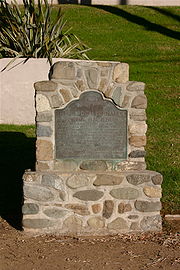
#226. A stone marker, placed by the California Centennials Commission and dedicated 3 May 1950, has a bronze plaque titled "Site of Don Bernardo Yorba Hacienda" which gives a brief summary of the historical background of the site. The marker faces south and is located on the northeast corner of Esperanza Road and Echo Hill Lane in Yorba Linda, at the entrance to the Fairmont Hill community. According to the plaque, the base was furnished by the Placentia Round Table Club and supposedly contains some of the original adobe bricks from the hacienda structure salvaged from the barranca where it was dumped. There are a few red bricks found on the backside, but most of the base seems to be made of large stones cemented together. The site marker is actually 55 yards northeast from the east wall of the original main structure. Based on survey reports registered with the county, the true site of this structure is parallel with the road in what is now the westbound fast lane of Esperanza road on the north side of the center divider, midway along the left turn lane opposite Echo Hill Lane.
The Yorba Cemetery, now surrounded by Woodgate Park and Woodgate Condominium Association, is the only surviving part of the Yorba Hacienda. The cemetery was deeded to the county of Orange in 1967 and is presently (2010) administered by the county parks department. Restoration efforts are underway and tours are available.
----
Bernardo Yorba
Bernardo Yorba , was a native of Nueva California and the son of Spanish soldier, José Antonio Yorba. Bernardo became one of the most successful ranchers in Alta California with thousands of cattle and horses grazing on land grants totaling more than 35,000 acres...
on the Rancho Cañón de Santa Ana
Rancho Cañón de Santa Ana
Rancho Cañón de Santa Ana was a land grant in present day Orange County, California given by Mexican governor José Figueroa in 1834 to Bernardo Yorba. The name means "Canyon of Santa Ana". The grant included present day Yorba Linda.-History:...
Mexican land grant
Ranchos of California
The Spanish, and later the Méxican government encouraged settlement of territory now known as California by the establishment of large land grants called ranchos, from which the English ranch is derived. Devoted to raising cattle and sheep, the owners of the ranchos attempted to pattern themselves...
, and located in the present city of Yorba Linda, California
Yorba Linda, California
Yorba Linda is a suburban city in northeastern Orange County, California, approximately northeast of Downtown Santa Ana, and southeast of Downtown Los Angeles....
. It was notable as the seat of the wealthiest member of the Yorba family and as the most palatial adobe
Adobe
Adobe is a natural building material made from sand, clay, water, and some kind of fibrous or organic material , which the builders shape into bricks using frames and dry in the sun. Adobe buildings are similar to cob and mudbrick buildings. Adobe structures are extremely durable, and account for...
hacienda in Alta California
Alta California
Alta California was a province and territory in the Viceroyalty of New Spain and later a territory and department in independent Mexico. The territory was created in 1769 out of the northern part of the former province of Las Californias, and consisted of the modern American states of California,...
. 33°51′51"N 117°46′51"W
Construction
On August 1 1834, Mexican Governor José FigueroaJosé Figueroa
General José Figueroa , was a General and the Mexican territorial Governor of Alta California from 1833 to 1835.Figueroa oversaw the initial secularization of the missions of upper California, which included the expulsion of the Spanish Franciscan mission officials.This also involved the issuing of...
granted to Bernardo Yorba 13328 acres (53.9 km²) on the north side of the Santa Ana River
Santa Ana River
The Santa Ana River is the largest river of Southern California in the United States. Its drainage basin spans four counties. It rises in the San Bernardino Mountains and flows past the cities of San Bernardino and Riverside, before cutting through the northern tip of the Santa Ana Mountains and...
, about four miles upstream from the José Antonio Yorba
José Antonio Yorba
José Antonio Yorba , also known as Don José Antonio Yorba I, was a Spanish soldier and early settler of Spanish California.-Spanish Soldier:...
hacienda "El Refugio" on Rancho Santiago de Santa Ana
Rancho Santiago de Santa Ana
Rancho Santiago de Santa Ana was a Spanish land concession in present day Orange County, California given by Governor José Joaquín de Arrillaga in 1810 to Jose Antonio Yorba and his nephew Pablo Peralta...
.
Bernardo Yorba Hacienda
In 1835, Bernardo Yorba began construction on a two-story adobeAdobe
Adobe is a natural building material made from sand, clay, water, and some kind of fibrous or organic material , which the builders shape into bricks using frames and dry in the sun. Adobe buildings are similar to cob and mudbrick buildings. Adobe structures are extremely durable, and account for...
house that was to be one of the finest and largest in all of Alta California
Alta California
Alta California was a province and territory in the Viceroyalty of New Spain and later a territory and department in independent Mexico. The territory was created in 1769 out of the northern part of the former province of Las Californias, and consisted of the modern American states of California,...
. Construction was completed in stages over several years. The main buildings were arranged to form three sides of a square and boasted 200 rooms, although older, more conservative accounts list at least fifty rooms. The southern face of the main structure was measured to be 106 feet in length and surviving photographs show it to be over 20 feet at the peak of the roof. Pine beams were cut and brought by oxen from the San Bernardino Mountains
San Bernardino Mountains
The San Bernardino Mountains are a short transverse mountain range north and east of San Bernardino in Southern California in the United States. The mountains run for approximately 60 miles east-west on the southern edge of the Mojave Desert in southwestern San Bernardino County, north of the...
to add support to the structures. Indian servants who made the adobe bricks used in construction lived in their own camp closer to the river, past the chapel just east of the northern end of the old Yorba Bridge (now Imperial Highway bridge).
Iglesia de San Antonio
Around the time of Bernardo's death in 1858, a small adobe chapel, Iglesia de San Antonio, was built about 1,000 yards southwest of the residence. It was dedicated on April 29 1860 to San Antonio, patron saint of the Yorba household. In the 1890s the adobe chapel was so weathered that a wooden church was built a few yards away on the west side. The wooden church was abandoned about 1948 and was gone by 1956.Yorba Cemetery
About the time the adobe chapel was built, a plot of land on the hill overlooking the hacienda to its southeast was set aside as the Yorba Cemetery. Over 400 people were buried there through the 1930s. Bernardo's remains, those of his second wife, and eight other Yorbas were re-interred there in 1923 when the Old Calvary CemeteryCalvary Cemetery, East Los Angeles
The Calvary Cemetery is a Roman Catholic cemetery operated by the Los Angeles Archdiocese, located at 4201 Whittier Boulevard in Los Angeles, California...
in Los Angeles
Los Ángeles
Los Ángeles is the capital of the province of Biobío, in the commune of the same name, in Region VIII , in the center-south of Chile. It is located between the Laja and Biobío rivers. The population is 123,445 inhabitants...
was closed due to construction. The last burials were in 1939.
Life at the Hacienda
The rancho headquarters, Hacienda de San Antonio, was also known as Rancho San Antonio. Other names include San Antonio de Santa Ana or San Antonio de los Yorbas. This was the center of all activity in the area in that time. In 1842 Governor Manuel MicheltorenaManuel Micheltorena
Manuel Micheltorena was a Brigadier General of the Mexican Army, Adjutant-General of the same, Governor, Commandant-General and Inspector of the Department of the California...
stayed at the Yorba homestead and supplied his soldiers with provisions from the ranch. On January 6 1847 General Stephen W. Kearny
Stephen W. Kearny
Stephen Watts Kearny surname also appears as Kearney in some historic sources; August 30, 1794 October 31, 1848), was one of the foremost antebellum frontier officers of the United States Army. He is remembered for his significant contributions in the Mexican-American War, especially the conquest...
and Commodore Robert F. Stockton
Robert F. Stockton
Robert Field Stockton was a United States naval commodore, notable in the capture of California during the Mexican-American War. He was a naval innovator and an early advocate for a propeller-driven, steam-powered navy. Stockton was from a notable political family and also served as a U.S...
camped just down stream from the hacienda, in a Yorba irrigation ditch which ran from the Santa Ana River to Santa Ana Vieja
Rancho Santiago de Santa Ana
Rancho Santiago de Santa Ana was a Spanish land concession in present day Orange County, California given by Governor José Joaquín de Arrillaga in 1810 to Jose Antonio Yorba and his nephew Pablo Peralta...
. Just days later they won the Battle of Rio San Gabriel
Battle of Rio San Gabriel
The Battle of Rio San Gabriel fought on January 8, 1847 was a decisive action of the California campaign of the Mexican-American War and occurred at a ford of the San Gabriel River, at what are today parts of the cities of Whittier, Pico Rivera and Montebello, about ten miles south-east of downtown...
near Los Angeles
Los Ángeles
Los Ángeles is the capital of the province of Biobío, in the commune of the same name, in Region VIII , in the center-south of Chile. It is located between the Laja and Biobío rivers. The population is 123,445 inhabitants...
, securing southern California for the Americans and leading to the end of Mexican rule in California
California
California is a state located on the West Coast of the United States. It is by far the most populous U.S. state, and the third-largest by land area...
.
Being far from the nearest town, Los Angeles, Bernado Yorba thought it wise to have all the trades represented on site. There were four woolcombers, two tanners, one soapmaker, and one butter and cheese man who supervised the milking of 50 to 60 cows. There was also a harness maker, two shoe makers, a jeweler, and one plasterer as well as a carpenter and a blacksmith. Yorba also had two errand boys, one sheepherder, a cook and a baker. Also employed were two washer women, one woman to iron, four sewing women, a dressmaker, two gardeners, a schoolmaster and winemakers. Among the wines made, Angelica
Angelica wine
Angelica wine is an historic sweet fortified wine usually from California made typically from the Mission grape. It is often served as a dessert wine....
and Port
Port wine
Port wine is a Portuguese fortified wine produced exclusively in the Douro Valley in the northern provinces of Portugal. It is typically a sweet, red wine, often served as a dessert wine, and comes in dry, semi-dry, and white varieties...
are mentioned, as well as the distilling of whiskey and brandy. Provisions were brought all the way from San Francisco for the hacienda; dates, dried fruits, fancy crackers and candy were also supplied to surrounding ranches. About 100 Gabrieleño Indians worked for Bernardo Yorba on the rancho, living in a nearby village.
As the auxiliary alcalde
Alcalde
Alcalde , or Alcalde ordinario, is the traditional Spanish municipal magistrate, who had both judicial and administrative functions. An alcalde was, in the absence of a corregidor, the presiding officer of the Castilian cabildo and judge of first instance of a town...
, Bernardo needed a place to keep lawbreakers. A jail was located between the main residence and the schoolrooms. The dark cellar below ground was called the 'dungeon' where criminals were locked up.
After the death of Bernardo Yorba in 1858, the Indian servants left and the hacienda went into a slow decline as property and land was divided among the Yorba heirs.
Destruction
In 1917 and again in late 1919, Don Meadows and Roch Bradshaw, two local students, visited the ruins to measure, photograph and study all they could. Don Meadows would later write a short account of their explorations, published as "The House of Bernardo Yorba" by the Orange County Historical Society. The Yorba family and the County Supervisors could not agree on the amount of land to be set aside for the preservation of the Yorba home. In 1926 the property's owner, Samuel KraemerSamuel Kraemer
Samuel Kraemer was an important rancher, farmer, and businessman who lived and worked in Anaheim, California.The son of Elenora Schraw and Daniel Kraemer, he grew up to acquire numerous land parcels and business interests throughout today's Orange County...
, demolished the building to prevent further vandalism, and plowed in a new barley field on the site. All the adobe ruins and the remaining trees were torn down and deposited into a barranca
Barranca
-Fiction:* Las Barrancas, a fictional town in a fictional county in the computer game, Grand Theft Auto* The guide Barranca in the opening scenes of Raiders of the Lost ArkDefinition:1. A deep ravine or gorge.2...
nearby. The Yorba cemetery closed in 1939 and thereafter vandals destroyed or stole many of the grave markers.
Present day
California Historical Landmark
California Historical Landmarks are buildings, structures, sites, or places in the state of California that have been determined to have statewide historical significance by meeting at least one of the criteria listed below:...
#226. A stone marker, placed by the California Centennials Commission and dedicated 3 May 1950, has a bronze plaque titled "Site of Don Bernardo Yorba Hacienda" which gives a brief summary of the historical background of the site. The marker faces south and is located on the northeast corner of Esperanza Road and Echo Hill Lane in Yorba Linda, at the entrance to the Fairmont Hill community. According to the plaque, the base was furnished by the Placentia Round Table Club and supposedly contains some of the original adobe bricks from the hacienda structure salvaged from the barranca where it was dumped. There are a few red bricks found on the backside, but most of the base seems to be made of large stones cemented together. The site marker is actually 55 yards northeast from the east wall of the original main structure. Based on survey reports registered with the county, the true site of this structure is parallel with the road in what is now the westbound fast lane of Esperanza road on the north side of the center divider, midway along the left turn lane opposite Echo Hill Lane.
The Yorba Cemetery, now surrounded by Woodgate Park and Woodgate Condominium Association, is the only surviving part of the Yorba Hacienda. The cemetery was deeded to the county of Orange in 1967 and is presently (2010) administered by the county parks department. Restoration efforts are underway and tours are available.
See also
- Ranchos of Orange CountyRanchos of Orange County-History:The County of Orange was established in 1889 by founders William Spurgeon and James McFadden. The City of Santa Ana became the county seat the same year. Prior to its formation, the Orange County lands were part of Los Angeles County....
- Ranchos of CaliforniaRanchos of CaliforniaThe Spanish, and later the Méxican government encouraged settlement of territory now known as California by the establishment of large land grants called ranchos, from which the English ranch is derived. Devoted to raising cattle and sheep, the owners of the ranchos attempted to pattern themselves...
- List of Ranchos of California
External links
- Microsoft Live Search Maps: Aerial view - Yorba Hacienda
- Orange County Historical Society | Yorba Hacienda
- State Historical Landmarks in Orange County: Yorba Hacienda
- Yorba Linda History website
----