Yehliu
Encyclopedia

Headland
A headland is a point of land, usually high and often with a sheer drop, that extends out into a body of water.Headland can also refer to:*Headlands and bays*headLand, an Australian television series...
on the north coast of Taiwan
Taiwan
Taiwan , also known, especially in the past, as Formosa , is the largest island of the same-named island group of East Asia in the western Pacific Ocean and located off the southeastern coast of mainland China. The island forms over 99% of the current territory of the Republic of China following...
in the town of Wanli between Taipei
Taipei
Taipei City is the capital of the Republic of China and the central city of the largest metropolitan area of Taiwan. Situated at the northern tip of the island, Taipei is located on the Tamsui River, and is about 25 km southwest of Keelung, its port on the Pacific Ocean...
and Keelung
Keelung
Keelung City is a major port city situated in the northeastern part of Taiwan. It borders New Taipei and forms the Taipei–Keelung metropolitan area, along with the Taipei and New Taipei. Nicknamed the Rainy Port for its frequent rain and maritime role, the city is Taiwan's second largest seaport...
.
The cape, known by geologists as the Yehliu Promontory, forms part of the Taliao Miocene
Miocene
The Miocene is a geological epoch of the Neogene Period and extends from about . The Miocene was named by Sir Charles Lyell. Its name comes from the Greek words and and means "less recent" because it has 18% fewer modern sea invertebrates than the Pliocene. The Miocene follows the Oligocene...
Formation. It stretches approximately 1,700 meters into the ocean and was formed as geological forces
Tectonics
Tectonics is a field of study within geology concerned generally with the structures within the lithosphere of the Earth and particularly with the forces and movements that have operated in a region to create these structures.Tectonics is concerned with the orogenies and tectonic development of...
pushed Datun Mountain (大屯山) out of the sea.
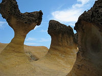
A distinctive feature of the cape is the hoodoo stones
Hoodoo (geology)
A hoodoo is a tall, thin spire of rock that protrudes from the bottom of an arid drainage basin or badland. Hoodoos consist of relatively soft rock topped by harder, less easily eroded stone that protects each column from the elements...
that dot its surface. These shapes can be viewed at the Yeliu Geopark operated by the North Coast and Guanyinshan National Scenic Area Administration. A number of rock formations have been given imaginative names based on their shapes. The most well-known is the "The Queen's Head" (女王頭), an iconic image in Taiwan and an unofficial emblem for the town of Wanli. Other formations include "The Fairy Shoe", "The Bee Hive", "The Ginger Rocks" and "The Sea Candles."
External links
- Taipei County Yehliu Scenic Area Administration
- Ocean World, a family attraction in Yehliu

