

Wroxham Broad
Encyclopedia
River Bure
The River Bure is a river in the county of Norfolk, England, most of it in The Broads. The Bure rises near Melton Constable, upstream of Aylsham, which was the original head of navigation. Nowadays, the head of navigation is downstream at Coltishall Bridge...
near the village of Wroxham
Wroxham
Wroxham is a village and civil parish in the English county of Norfolk. The civil parish of Wroxham has an area of 6.21 square kilometres and in 2001 had a population of 1532 in 666 households. The village is situated within the Norfolk Broads on the south side of a loop in the middle reaches of...
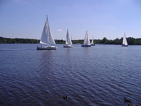
in Norfolk, England within The Broads National Park. The broad has an area of 34.4 hectares and a mean depth of 1.3 metres. It lies to the west of the Bure, with two navigable openings between river and broad. The village and broad lie in an area of fairly intensive agriculture, with areas of wet woodland adjoining the broad and river.
The broad is home to the Norfolk Broads Yacht
Yacht
A yacht is a recreational boat or ship. The term originated from the Dutch Jacht meaning "hunt". It was originally defined as a light fast sailing vessel used by the Dutch navy to pursue pirates and other transgressors around and into the shallow waters of the Low Countries...
Club. Visiting boats are not allowed to land, but navigation is allowed.
There is a locomotive at the Bure Valley Railway
Bure Valley Railway
The Bure Valley Railway is a minimum gauge heritage railway in Norfolk, within The Broads National Park.The railway runs from Wroxham to Aylsham and is Norfolk's longest railway of less than standard gauge. It uses both steam and diesel locomotives. There are intermediate halts at Brampton,...
in Norfolk
Norfolk
Norfolk is a low-lying county in the East of England. It has borders with Lincolnshire to the west, Cambridgeshire to the west and southwest and Suffolk to the south. Its northern and eastern boundaries are the North Sea coast and to the north-west the county is bordered by The Wash. The county...
which is named after Wroxham Broad.
Between 2000 and 2005 the island between the two channels linking Wroxham Broad to the Bure underwent restoration to stop erosion and improve the island's ecology, which had become degraded. The project was a joint initiative involving the Broads Authority
Broads Authority
The Broads Authority is the agency which has statutory responsibility for the Broads in England. Originally, the Nature Conservancy Council , pressed for a special authority to manage the Broads which had been neglected for a long time. In 1978, the forerunner to the present-day Broads Authority...
, Norfolk Broads Yacht Club and the local landowner, Trafford Estates. Scrub was cleared and a stretch of piling installed, allowing sedge, reed and rush to grow back. By 2005 it was reported that more birds, including kingfishers, were nesting on the island and the rare Cetti's warbler was often spotted. Greater numbers of ducks, including pochard and tufted ducks, now wintered nearby and there was a greater profusion of wild flowers and marsh flora including orchids. During the course of the work, in 2004, volunteers came across an unexploded Second World War hand grenade in the dredgings, which had to be exploded by an army bomb disposal team.
Close to Wroxham Broad stands the early 18th century Broad House, a Queen Anne style
Queen Anne Style architecture
The Queen Anne Style in Britain means either the English Baroque architectural style roughly of the reign of Queen Anne , or a revived form that was popular in the last quarter of the 19th century and the early decades of the 20th century...
estate house and formerly the seat of the local land-owning Trafford family, more recently a 'boutique' hotel.