

Wright Patman Lake
Encyclopedia
Reservoir
A reservoir , artificial lake or dam is used to store water.Reservoirs may be created in river valleys by the construction of a dam or may be built by excavation in the ground or by conventional construction techniques such as brickwork or cast concrete.The term reservoir may also be used to...
in northeast Texas
Texas
Texas is the second largest U.S. state by both area and population, and the largest state by area in the contiguous United States.The name, based on the Caddo word "Tejas" meaning "friends" or "allies", was applied by the Spanish to the Caddo themselves and to the region of their settlement in...
in the United States
United States
The United States of America is a federal constitutional republic comprising fifty states and a federal district...
. The lake is a U.S. Army Corps of Engineers
United States Army Corps of Engineers
The United States Army Corps of Engineers is a federal agency and a major Army command made up of some 38,000 civilian and military personnel, making it the world's largest public engineering, design and construction management agency...
reservoir formed on the Sulphur River
Sulphur River
The Sulphur River is a river in northeast Texas and southwest Arkansas in the United States.-Geography:The Sulphur River begins at the confluence of its north and south forks along the Delta–Lamar county line...
in Bowie
Bowie County, Texas
Bowie County is a county located in the U.S. state of Texas. It is part of the Texarkana, Texas - Texarkana, Arkansas, Metropolitan Statistical Area. As of 2000, the population was 89,306. Its legal county seat is Boston, though its courthouse is located in New Boston...
and Cass
Cass County, Texas
As of the census of 2000, there were 30,438 people, 12,190 households, and 8,654 families residing in the county. The population density was 32 people per square mile . There were 13,890 housing units at an average density of 15 per square mile...
counties by Wright Patman Dam
Wright Patman Dam
Wright Patman Dam is an earth-fill dam across the Sulphur River in northeast Texas in the United States. The water impounded by the dam forms Wright Patman Lake.-Geography:...
. The reservoir provides flood control
Flood control
In communications, flood control is a feature of many communication protocols designed to prevent overwhelming of a destination receiver. Such controls can be implemented either in software or in hardware, and will often request that the message be resent after the receiver has finished...
and water conservation for the communities downstream from the dam. The lake is also a popular recreational destination. The Bowie County Side of the lake is part of the Texarkana metropolitan area
Texarkana metropolitan area
The Texarkana, TX-Texarkana, AR Metropolitan Statistical Area , as defined by the United States Office of Management and Budget, is a two-county region anchored by the twin cities of Texarkana, Texas and Texarkana, Arkansas, and encompassing the surrounding communities in Bowie County, Texas and...
.
Geography
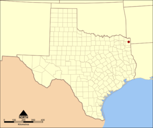
Wright Patman Lake is located at 33°16′48"N 94°18′00"W. It is located on the border between Bowie CountyBowie County, Texas
Bowie County is a county located in the U.S. state of Texas. It is part of the Texarkana, Texas - Texarkana, Arkansas, Metropolitan Statistical Area. As of 2000, the population was 89,306. Its legal county seat is Boston, though its courthouse is located in New Boston...
and Cass County
Cass County, Texas
As of the census of 2000, there were 30,438 people, 12,190 households, and 8,654 families residing in the county. The population density was 32 people per square mile . There were 13,890 housing units at an average density of 15 per square mile...
, Texas
Texas
Texas is the second largest U.S. state by both area and population, and the largest state by area in the contiguous United States.The name, based on the Caddo word "Tejas" meaning "friends" or "allies", was applied by the Spanish to the Caddo themselves and to the region of their settlement in...
, and the geographic center is about 18 miles (29 km) southwest of Texarkana, Texas
Texarkana, Texas
Texarkana is a city in Bowie County, Texas, United States. It effectively functions as one half of a city which crosses a state line — the other half, the city of Texarkana, Arkansas, lies on the other side of State Line Avenue...
and 148 miles (238 km) east of Dallas
Dallas, Texas
Dallas is the third-largest city in Texas and the ninth-largest in the United States. The Dallas-Fort Worth Metroplex is the largest metropolitan area in the South and fourth-largest metropolitan area in the United States...
. Towns in the immediate vicinity of the lake include Redwater, Maud, and Douglassville, Texas
Douglassville, Texas
Douglassville is a town in Cass County, Texas, United States. The population was 175 at the 2000 census.-Geography:Douglassville is located at .According to the United States Census Bureau, the town has a total area of , all of it land.-Demographics:...
.
The lake is formed by water impounded by Wright Patman Dam. The water is mainly from the Sulphur River, but several smaller creeks also flow into the lake. The lake's conservation pool level is 220.6 feet (67.2 m) above sea level
Sea level
Mean sea level is a measure of the average height of the ocean's surface ; used as a standard in reckoning land elevation...
, and the spillway level is at 259.5 feet (79.1 m) above sea level.
History
Wright Patman Lake and Dam were authorized as part of the United States' Flood Contract Act of 1946. Originally known as Texarkana Reservoir, the lake was later renamed to Lake Texarkana. Construction of the dam began in 1948, and the lake was formed when water was impounded in 1953. In 1973, the lake and dam were renamed in honor of Congressman Wright PatmanWright Patman
John William Wright Patman was a U.S. Congressman from Texas in Texas's 1st congressional district and chair of the United States House Committee on Banking and Currency .-Early life:...
of Texas.
Flood protection
Wright Patman Lake provides floodFlood
A flood is an overflow of an expanse of water that submerges land. The EU Floods directive defines a flood as a temporary covering by water of land not normally covered by water...
protection for areas downstream along the Sulphur River and Red River
Red River (Mississippi watershed)
The Red River, or sometimes the Red River of the South, is a major tributary of the Mississippi and Atchafalaya Rivers in the southern United States of America. The river gains its name from the red-bed country of its watershed. It is one of several rivers with that name...
. In the 38.9 feet (11.9 m) between its conservation pool and spillway levels, the lake can hold 2406000 acre.ft of flood water.
Recreation
The U.S. Army Corps of Engineers maintains nine parks around Wright Patman Lake. These parks provide lake access for boating, swimming, and fishing; as well as camping, picnicking, hiking, equestrianEquestrianism
Equestrianism more often known as riding, horseback riding or horse riding refers to the skill of riding, driving, or vaulting with horses...
trails, and other outdoor activities. Atlanta State Park
Atlanta State Park
Atlanta State Park is a state park in northeast Texas in the United States. It is located on Wright Patman Lake in northern Cass County.-Location:...
is also located on the south shore of the lake.
External links
- Wright Patman Lake information from the U.S. Army Corps of Engineers
- Atlanta State Park information from the Texas Parks & Wildlife Department