

Wrekinset
Encyclopedia
The Wreocensæte sometimes anglicized as the Wrekinsets, were one of the peoples of Anglo-Saxon Britain
. Their name approximates to "Wrekin-dwellers". It is also suggested that Wrexham
also derived from Wreocensæte. This area would have been a mixed Anglo-Saxon-Celtic sub kingdom in which was probably of the first evidences of Anglo-Saxon-Celtic multiculturalism.
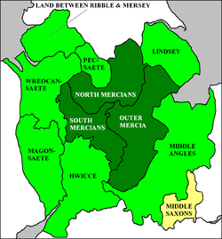 The boundaries of the kingdom are uncertain, but it was substantial as the Tribal Hidage
lists it as 7000 hide
s, equal to the kingdoms of the East Saxons and South Saxons. The evidence suggests that the Wrekinset were the most northerly of the three large Mercia
n subject kingdoms facing Wales
, with the Magonsæte to their south, and the Hwicce
farthest south. The chief place was seemingly the former Roman Viroconium Cornoviorum (modern Wroxeter
), the former civitas
of the Cornovii and close to the hill fort known as The Wrekin
. The kingdom may have covered much of modern Cheshire
, Shropshire
and into North East Wales
, Wrexham
, Denbighshire
and Flintshire
. The border between Wales
and Wreocensæte would have been Offa's Dyke
.
As with the neighbouring Magonsæte, the lands of the Wreocensæte appear to have included a number of lesser tribes or kingdoms. Place-names suggest that the much smaller Meresæte, Rhiwsæte and Halhsæte lay within the lands of the Magonsæte. These, and the more southerly examples in Magonsæte, appear to be spaced regularly along the line of the frontier with Wales, and it is suggested that they may be artificial in origin, created by a king of Mercia to delineate and defend that border.
Anglo-Saxons
Anglo-Saxon is a term used by historians to designate the Germanic tribes who invaded and settled the south and east of Great Britain beginning in the early 5th century AD, and the period from their creation of the English nation to the Norman conquest. The Anglo-Saxon Era denotes the period of...
. Their name approximates to "Wrekin-dwellers". It is also suggested that Wrexham
Wrexham
Wrexham is a town in Wales. It is the administrative centre of the wider Wrexham County Borough, and the largest town in North Wales, located in the east of the region. It is situated between the Welsh mountains and the lower Dee Valley close to the border with Cheshire, England...
also derived from Wreocensæte. This area would have been a mixed Anglo-Saxon-Celtic sub kingdom in which was probably of the first evidences of Anglo-Saxon-Celtic multiculturalism.
Tribal Hidage
Image:Tribal Hidage 2.svg|thumb|400px|alt=insert description of map here|The tribes of the Tribal Hidage. Where an appropriate article exists, it can be found by clicking on the name.rect 275 75 375 100 Elmetrect 375 100 450 150 Hatfield Chase...
lists it as 7000 hide
Hide (unit)
The hide was originally an amount of land sufficient to support a household, but later in Anglo-Saxon England became a unit used in assessing land for liability to "geld", or land tax. The geld would be collected at a stated rate per hide...
s, equal to the kingdoms of the East Saxons and South Saxons. The evidence suggests that the Wrekinset were the most northerly of the three large Mercia
Mercia
Mercia was one of the kingdoms of the Anglo-Saxon Heptarchy. It was centred on the valley of the River Trent and its tributaries in the region now known as the English Midlands...
n subject kingdoms facing Wales
Wales
Wales is a country that is part of the United Kingdom and the island of Great Britain, bordered by England to its east and the Atlantic Ocean and Irish Sea to its west. It has a population of three million, and a total area of 20,779 km²...
, with the Magonsæte to their south, and the Hwicce
Hwicce
The Hwicce were one of the peoples of Anglo-Saxon England. The exact boundaries of their kingdom are uncertain, though it is likely that they coincided with those of the old Diocese of Worcester, founded in 679–80, the early bishops of which bore the title Episcopus Hwicciorum...
farthest south. The chief place was seemingly the former Roman Viroconium Cornoviorum (modern Wroxeter
Wroxeter
Wroxeter is a village in Shropshire, England. It forms part of the civil parish of Wroxeter and Uppington and is located in the Severn Valley about south-east of Shrewsbury.-History:...
), the former civitas
Civitas
In the history of Rome, the Latin term civitas , according to Cicero in the time of the late Roman Republic, was the social body of the cives, or citizens, united by law . It is the law that binds them together, giving them responsibilities on the one hand and rights of citizenship on the other...
of the Cornovii and close to the hill fort known as The Wrekin
The Wrekin
The Wrekin is a hill in east Shropshire, England. It is located some west of Telford, on the border between the unitary authorities of Shropshire and Telford and Wrekin. Rising to a height of above the Shropshire Plain, it is a prominent and well-known landmark, marking the entrance to Shropshire...
. The kingdom may have covered much of modern Cheshire
Cheshire
Cheshire is a ceremonial county in North West England. Cheshire's county town is the city of Chester, although its largest town is Warrington. Other major towns include Widnes, Congleton, Crewe, Ellesmere Port, Runcorn, Macclesfield, Winsford, Northwich, and Wilmslow...
, Shropshire
Shropshire
Shropshire is a county in the West Midlands region of England. For Eurostat purposes, the county is a NUTS 3 region and is one of four counties or unitary districts that comprise the "Shropshire and Staffordshire" NUTS 2 region. It borders Wales to the west...
and into North East Wales
Wales
Wales is a country that is part of the United Kingdom and the island of Great Britain, bordered by England to its east and the Atlantic Ocean and Irish Sea to its west. It has a population of three million, and a total area of 20,779 km²...
, Wrexham
Wrexham
Wrexham is a town in Wales. It is the administrative centre of the wider Wrexham County Borough, and the largest town in North Wales, located in the east of the region. It is situated between the Welsh mountains and the lower Dee Valley close to the border with Cheshire, England...
, Denbighshire
Denbighshire
Denbighshire is a county in north-east Wales. It is named after the historic county of Denbighshire, but has substantially different borders. Denbighshire has the distinction of being the oldest inhabited part of Wales. Pontnewydd Palaeolithic site has remains of Neanderthals from 225,000 years...
and Flintshire
Flintshire
Flintshire is a county in north-east Wales. It borders Denbighshire, Wrexham and the English county of Cheshire. It is named after the historic county of Flintshire, which had notably different borders...
. The border between Wales
Wales
Wales is a country that is part of the United Kingdom and the island of Great Britain, bordered by England to its east and the Atlantic Ocean and Irish Sea to its west. It has a population of three million, and a total area of 20,779 km²...
and Wreocensæte would have been Offa's Dyke
Offa's Dyke
Offa's Dyke is a massive linear earthwork, roughly followed by some of the current border between England and Wales. In places, it is up to wide and high. In the 8th century it formed some kind of delineation between the Anglian kingdom of Mercia and the Welsh kingdom of Powys...
.
As with the neighbouring Magonsæte, the lands of the Wreocensæte appear to have included a number of lesser tribes or kingdoms. Place-names suggest that the much smaller Meresæte, Rhiwsæte and Halhsæte lay within the lands of the Magonsæte. These, and the more southerly examples in Magonsæte, appear to be spaced regularly along the line of the frontier with Wales, and it is suggested that they may be artificial in origin, created by a king of Mercia to delineate and defend that border.