

Wramplingham
Encyclopedia
Village
A village is a clustered human settlement or community, larger than a hamlet with the population ranging from a few hundred to a few thousand , Though often located in rural areas, the term urban village is also applied to certain urban neighbourhoods, such as the West Village in Manhattan, New...
and civil parish
Civil parish
In England, a civil parish is a territorial designation and, where they are found, the lowest tier of local government below districts and counties...
in the English
England
England is a country that is part of the United Kingdom. It shares land borders with Scotland to the north and Wales to the west; the Irish Sea is to the north west, the Celtic Sea to the south west, with the North Sea to the east and the English Channel to the south separating it from continental...
county
County
A county is a jurisdiction of local government in certain modern nations. Historically in mainland Europe, the original French term, comté, and its equivalents in other languages denoted a jurisdiction under the sovereignty of a count A county is a jurisdiction of local government in certain...
of Norfolk
Norfolk
Norfolk is a low-lying county in the East of England. It has borders with Lincolnshire to the west, Cambridgeshire to the west and southwest and Suffolk to the south. Its northern and eastern boundaries are the North Sea coast and to the north-west the county is bordered by The Wash. The county...
. It is situated on the River Tiffey
River Tiffey
The River Tiffey is a small river in Norfolk, England and a tributary of the River Yare. It rises near Hethel and passes through Wymondham before flowing generally north-eastwards passing through Kimberley, Carleton Forehoe, Wramplingham and Barford before joining the River Yare at Swan's Harbour....
some 4 miles (6.4 km) north of Wymondham
Wymondham
Wymondham is a historic market town and civil parish in the English county of Norfolk. It lies 9.5 miles to the south west of the city of Norwich, on the A11 road to Thetford and London.- Before The Great Fire :...
and 7 miles (11.3 km) west of Norwich
Norwich
Norwich is a city in England. It is the regional administrative centre and county town of Norfolk. During the 11th century, Norwich was the largest city in England after London, and one of the most important places in the kingdom...
.
The civil parish has an area of 3.47 square kilometres and in 2001 had a population of 110 in 44 households. For the purposes of local government, the parish falls within the district
Non-metropolitan district
Non-metropolitan districts, or colloquially shire districts, are a type of local government district in England. As created, they are sub-divisions of non-metropolitan counties in a so-called "two-tier" arrangement...
of South Norfolk
South Norfolk
South Norfolk is a local government district in Norfolk, England. Its council is based in Long Stratton.-History:The district was formed on April 1, 1974, under the Local Government Act 1972, as a merger of Diss Urban District, Wymondham Urban District, Depwade Rural District, Forehoe and Henstead...
. The renowned author Bill Bryson
Bill Bryson
William McGuire "Bill" Bryson, OBE, is a best-selling American author of humorous books on travel, as well as books on the English language and on science. Born an American, he was a resident of Britain for most of his adult life before moving back to the US in 1995...
lives in the old rectory, which is screened by trees from the village.
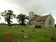
The church of Wramplingham St Peter and St Paul is one of 124 existing round-tower church
Round-tower church
Round-tower churches are a type of church found mainly in England, almost solely in East Anglia; of about 185 surviving examples in the country, 124 are in Norfolk, 38 in Suffolk, 6 in Essex, 3 in Sussex and 2 each in Cambridgeshire and Berkshire. There is evidence of about twenty round-tower...
es in Norfolk
Norfolk
Norfolk is a low-lying county in the East of England. It has borders with Lincolnshire to the west, Cambridgeshire to the west and southwest and Suffolk to the south. Its northern and eastern boundaries are the North Sea coast and to the north-west the county is bordered by The Wash. The county...
. The round tower at Wramplingham is thought to have originally been an Anglo-Saxon watch tower.
Wramplingham Mill was a 3 storey weatherboarded corn mill, demolished in 1945.
Prospect
Wramplingham is currently undergoing a scoping survey for a major energy supplier, with a view to building a 30 acre (350 sq.m) electrical substation, immediately adjacent to this conservation village. The site will be clearly visible from the round-tower church of Wramplingham, and from land used by the villagers and ramblers for walking.Barford is an alternative to the Wramplingham site. This land is immediately adjacent to the B1108, and slopes down to the River Tiffey. It will be able to supply energy for at least 230,000 homes, potentially 440,000 homes.
External links
.- Information from Genuki Norfolk on Wramplingham.
- Website with photos of Wramplingham St Peter and St Paul, a round-tower churchRound-tower churchRound-tower churches are a type of church found mainly in England, almost solely in East Anglia; of about 185 surviving examples in the country, 124 are in Norfolk, 38 in Suffolk, 6 in Essex, 3 in Sussex and 2 each in Cambridgeshire and Berkshire. There is evidence of about twenty round-tower...
- Wramplingham Mill
- Barford & Wramplingham Village Hall Website for the two villages with regularly updated event information.