
Wipperfeld
Encyclopedia
| Position | |
|---|---|
 |
|
| Information | |
| Population:(2-28-2005) | 1.876 |
| Population of the district:(12-31-2002) | 1.698 |
| Geographical position: | 7° 19' 28" Ost 51° 05' 20" Nord |
| Height above sealevel | 250 - 280m |
| Postal code : | 51688 |
| Prefix: | 02268 |
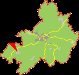
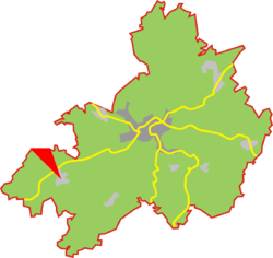
Wipperfeld is village and a district in the town of Wipperfürth
Wipperfürth
thumb|310px|Map of the citythumb|250px|Town hallWipperfürth is a municipality in the Oberbergischer Kreis of North Rhine-Westfalia, Germany, about 40 km north-east of Cologne, and the oldest town in the Bergischen Land.-History:...
which is a Northrhine-Westphalian municipality in the Oberbergischer Kreis, about 40 km north-east of Cologne
Cologne
Cologne is Germany's fourth-largest city , and is the largest city both in the Germany Federal State of North Rhine-Westphalia and within the Rhine-Ruhr Metropolitan Area, one of the major European metropolitan areas with more than ten million inhabitants.Cologne is located on both sides of the...
.
Geographical position
Wipperfeld is set in the west of Wipperfürth, next to the federal road B506 from Wipperfürth to Bergisch GladbachBergisch Gladbach
' is a city in the Cologne/Bonn Region of North Rhine-Westphalia, Germany and capital of the Rheinisch-Bergischer Kreis .-Geography:Bergisch Gladbach is located east of the river Rhine, approx...
.
Villages proximate to Wipperfeld are Lamsfuß, Erlen, Grüterich, Überberg and Oberholl.
The river "Wipperfelder Bach" runs through the village.
The district Wipperfeld
The district Wipperfeld consists of the following villages:Arnsberg - Birkerhof - Boxberg - Buchholz - Ente - Erlen - Fahlenbock - Frößeln - Gerhardsfeld - Grund - Grunewald - Hamböcken - Heid - Herweg - Hüffen - Julsiefen - Kofeln - Lamsfuß - Lieth - Mittelschneppen - Mittelschwarzen - Neumühle - Niederdhünn - Oberholl - Obermausbach - Oberschneppen - Oberschwarzen - Pannenhöh - Sommerberg - Überberg - Unterholl - Untermausbach - Unterschneppen - Unterschwarzen - Wüstenhof
History
The village was first mentioned as Wippervelde in the year of 1300.Mediaeval Times
In mediaeval times the village formed a part of the department of Steinbach (LindlarLindlar
Lindlar is a municipality in the Oberbergischer Kreis, in North Rhine-Westphalia, Germany. It is located about 30 km east of Cologne.-Geography:Lindlar is located between latitudes 50°58' and 51°5' N. and longitudes 7°15' and 7°28' E...
) and belonged to the district of the country court in Lindlar.
The parish church of Wipperfeld was built in the 12th century. The present-day church was built in 1892 and consecrated
Consecration
Consecration is the solemn dedication to a special purpose or service, usually religious. The word "consecration" literally means "to associate with the sacred". Persons, places, or things can be consecrated, and the term is used in various ways by different groups...
in 1894.
Modern Times
Up unto the 19th century a flour mill was in operation. The mill is identified in the "Statistik des Bergischen Landes von 1797".In 1890 Mr Mausbach from Wipperfeld was elected as the mayor of Lindlar.
Up to 1975 an independent municipality of Wipperfeld existed.
Federal roads
The federal road B506 from Wipperfürth to Bergisch Gladbach runs next to Wipperfeld.Bus routes
Bus stops Wipperfeld, Wipperfeld, Wende, Wipperfeld, Kirche:- VRS (KWS) 427 to Bergisch Gladbach (S) via Kürten-Weiden
- VRS (KWS) 426 to Bergisch Gladbach (S) via Kürten
German
- Führer, Gerhard: Alarm durch Läuten, Blasen und Trommelschlagen : die Feuerwehren von Olpe und Wipperfeld in früherer Zeit. In: Rhein.-Berg. Kalender 66. 1996 (1995) S. 183-187
- 75 Jahre St.-Seb.-Schützenbruderschaft Wipperfeld 1921 e. V. Wipperfeld 1996