

Winnipeg Route 52
Encyclopedia
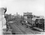
Route 52 is a major north-south arterial route in Winnipeg, Manitoba. It comprises all of Main Street from the northern city limits to the Main Street Bridge over the Assiniboine River
; Queen Elizabeth Way from the Main Street Bridge to the Norwood Bridge over the Red River
; and St. Mary's Road from the Norwood Bridge south to the city limits. At the northern city limits Route 52 becomes Manitoba Highway 9; in the south it becomes Manitoba Provincial Road 200
.
The route runs as Main Street roughly parallel to the west bank of the Red River in the northern half of the city. After passing through downtown, it runs roughly parallel to the east bank of the meandering
Red River in the south. It passes through the suburbs of West Kildonan, the North End, Downtown
, Fort Rouge, St. Boniface
, and St. Vital. The section between Broadway and St. Anne's Road is part of Manitoba Highway 1, the Trans-Canada Highway
.
The short section named Queen Elizabeth Way was named after Queen Elizabeth II, Queen of Canada. The section named St. Mary's Road was named after St. Mary's Parish (Ste. Marie Paroisse in French), a Roman Catholic parish located in the northernmost section of St. Vital.
Assiniboine River
The Assiniboine River is a river that runs through the prairies of Western Canada in Saskatchewan and Manitoba. It is a tributary of the Red River. The Assiniboine is a typical meandering river with a single main channel embanked within a flat, shallow valley in some places and a steep valley in...
; Queen Elizabeth Way from the Main Street Bridge to the Norwood Bridge over the Red River
Red River of the North
The Red River is a North American river. Originating at the confluence of the Bois de Sioux and Otter Tail rivers in the United States, it flows northward through the Red River Valley and forms the border between the U.S. states of Minnesota and North Dakota before continuing into Manitoba, Canada...
; and St. Mary's Road from the Norwood Bridge south to the city limits. At the northern city limits Route 52 becomes Manitoba Highway 9; in the south it becomes Manitoba Provincial Road 200
Manitoba Provincial Road 200
Provincial Road 200 is a provincial road in the Canadian province of Manitoba. It runs from the Winnipeg city limits to the border town of Emerson, joining Manitoba Highway 75 in Emerson at the United States border.- Route description :...
.
The route runs as Main Street roughly parallel to the west bank of the Red River in the northern half of the city. After passing through downtown, it runs roughly parallel to the east bank of the meandering
Meander
A meander in general is a bend in a sinuous watercourse. A meander is formed when the moving water in a stream erodes the outer banks and widens its valley. A stream of any volume may assume a meandering course, alternately eroding sediments from the outside of a bend and depositing them on the...
Red River in the south. It passes through the suburbs of West Kildonan, the North End, Downtown
Downtown Winnipeg
Downtown Winnipeg is centred around Portage Avenue and Main Street, and is bounded by the Assiniboine River on the south, Colony and Balmoral Streets on the west, Notre Dame Avenue, Princess Street, and Logan Avenue on the north, and the Red River on the east. It includes the Exchange District,...
, Fort Rouge, St. Boniface
Saint Boniface, Manitoba
Saint Boniface is a city ward of Winnipeg, home to much of the Franco-Manitoban community. It features such landmarks as the Cathédrale de Saint Boniface , Boulevard Provencher, the Provencher Bridge, Esplanade Riel, St. Boniface Hospital, the Collège universitaire de Saint-Boniface and the Royal...
, and St. Vital. The section between Broadway and St. Anne's Road is part of Manitoba Highway 1, the Trans-Canada Highway
Trans-Canada Highway
The Trans-Canada Highway is a federal-provincial highway system that joins the ten provinces of Canada. It is, along with the Trans-Siberian Highway and Australia's Highway 1, one of the world's longest national highways, with the main route spanning 8,030 km...
.
The short section named Queen Elizabeth Way was named after Queen Elizabeth II, Queen of Canada. The section named St. Mary's Road was named after St. Mary's Parish (Ste. Marie Paroisse in French), a Roman Catholic parish located in the northernmost section of St. Vital.