

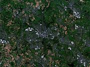
Wigan Urban Area
Encyclopedia
Office for National Statistics
The Office for National Statistics is the executive office of the UK Statistics Authority, a non-ministerial department which reports directly to the Parliament of the United Kingdom.- Overview :...
consisting of the built-up, or 'urbanised' area containing Wigan
Wigan
Wigan is a town in Greater Manchester, England. It stands on the River Douglas, south-west of Bolton, north of Warrington and west-northwest of Manchester. Wigan is the largest settlement in the Metropolitan Borough of Wigan and is its administrative centre. The town of Wigan had a total...
in Greater Manchester
Greater Manchester
Greater Manchester is a metropolitan county in North West England, with a population of 2.6 million. It encompasses one of the largest metropolitan areas in the United Kingdom and comprises ten metropolitan boroughs: Bolton, Bury, Oldham, Rochdale, Stockport, Tameside, Trafford, Wigan, and the...
and Skelmersdale
Skelmersdale
Skelmersdale is a town in West Lancashire, England. It lies on high-ground on the River Tawd, to the west of Wigan, to the northeast of Liverpool, south-southwest of Preston. As of 2006, Skelmersdale had a population of 38,813, down from 41,000 in 2004. The town is known locally as Skem.The...
in West Lancashire
West Lancashire
West Lancashire is a non-metropolitan district with the status of a borough in Lancashire, England. Its council is based in Ormskirk. The other town in the borough is Skelmersdale....
.
The Urban Area includes the integrated conurbation around Wigan, (containing the areas of Ince-in-Makerfield
Ince-in-Makerfield
Ince-in-Makerfield, usually known just as Ince is a district of the Metropolitan Borough of Wigan, in Greater Manchester, England.Ince is contiguous to Wigan and serves as a residential suburb of Wigan, Being divided locally by a train line into two separate areas - Higher Ince and Lower Ince,...
, Orrell
Orrell, Greater Manchester
Orrell is an area of the Metropolitan Borough of Wigan, Greater Manchester, England. The area is contiguous to the town of Wigan itself and the centre of the district is situated to the west of the town centre...
and Wigan itself), along with the areas of Standish
Standish, Greater Manchester
Standish is a village within the Metropolitan Borough of Wigan, in Greater Manchester, England. It is located on the A49 road between the towns of Chorley and Wigan, a short distance from Junction 27 of the M6 motorway....
, Abram
Abram, Greater Manchester
Abram is a village and electoral ward within the Metropolitan Borough of Wigan, in Greater Manchester, England. It lies on flat land on the northeast bank of the Leeds and Liverpool Canal, west of Leigh, southeast of Wigan, and west of Manchester...
and the West Lancashire
West Lancashire
West Lancashire is a non-metropolitan district with the status of a borough in Lancashire, England. Its council is based in Ormskirk. The other town in the borough is Skelmersdale....
town of Skelmersdale
Skelmersdale
Skelmersdale is a town in West Lancashire, England. It lies on high-ground on the River Tawd, to the west of Wigan, to the northeast of Liverpool, south-southwest of Preston. As of 2006, Skelmersdale had a population of 38,813, down from 41,000 in 2004. The town is known locally as Skem.The...
.
The Wigan Urban Area has a total population of 166,840.
Constituent parts
The historic town of Wigan forms an integrated conurbation along with the Metropolitan Borough of WiganMetropolitan Borough of Wigan
The Metropolitan Borough of Wigan is a metropolitan borough of Greater Manchester, in North West England. It is named after its largest component town, Wigan and also includes the towns of Leigh, Ashton-in-Makerfield, Ince-in-Makerfield, and Hindley. The borough was formed in 1974 and is an...
districts of Orrell
Orrell, Greater Manchester
Orrell is an area of the Metropolitan Borough of Wigan, Greater Manchester, England. The area is contiguous to the town of Wigan itself and the centre of the district is situated to the west of the town centre...
and Ince-in-Makerfield
Ince-in-Makerfield
Ince-in-Makerfield, usually known just as Ince is a district of the Metropolitan Borough of Wigan, in Greater Manchester, England.Ince is contiguous to Wigan and serves as a residential suburb of Wigan, Being divided locally by a train line into two separate areas - Higher Ince and Lower Ince,...
, this is connected by ribbon development to Standish
Standish, Greater Manchester
Standish is a village within the Metropolitan Borough of Wigan, in Greater Manchester, England. It is located on the A49 road between the towns of Chorley and Wigan, a short distance from Junction 27 of the M6 motorway....
and Abram
Abram, Greater Manchester
Abram is a village and electoral ward within the Metropolitan Borough of Wigan, in Greater Manchester, England. It lies on flat land on the northeast bank of the Leeds and Liverpool Canal, west of Leigh, southeast of Wigan, and west of Manchester...
. These areas, together with Skelmersdale
Skelmersdale
Skelmersdale is a town in West Lancashire, England. It lies on high-ground on the River Tawd, to the west of Wigan, to the northeast of Liverpool, south-southwest of Preston. As of 2006, Skelmersdale had a population of 38,813, down from 41,000 in 2004. The town is known locally as Skem.The...
in West Lancashire
West Lancashire
West Lancashire is a non-metropolitan district with the status of a borough in Lancashire, England. Its council is based in Ormskirk. The other town in the borough is Skelmersdale....
, are defined by the Office for National Statistics
Office for National Statistics
The Office for National Statistics is the executive office of the UK Statistics Authority, a non-ministerial department which reports directly to the Parliament of the United Kingdom.- Overview :...
as the Wigan Urban Area.
Breakdown
The ONS figures were broken down into constituent parts, and an individual population figure given for each. These were:| Rank (2001) | Urban sub-area name | 2001 | 1991 | 1981 |
|---|---|---|---|---|
| 1 | Wigan | 81,203 | 85,819 | 88,901 |
| 2 | Skelmersdale | 39,279 | 42,104 | 42,609 |
| 3 | Standish | 14,350 | 12,196 | 11,532 |
| 4 | Orrell | 11,212 | 12,251 | 12,600 |
| 5 | Ince in Makerfield | 10,941 | 10,554 | 11,013 |
| 6 | Abram | 9,855 | 11,482 | 12,423 |
| Total | 166,840 | 174,406 | 179,078 | |