
White Rose Walk
Encyclopedia
The White Rose Walk located in North Yorkshire
, England
, was devised in 1968 by the Yorkshire Wayfarers, It starts at the Kilburn White Horse
(National Grid Ref SE 514 813) and is completed by touching the trig point on top of Roseberry Topping
(NZ 579 126). The walk whilst recognised by the Long Distance Walkers Association
(LDWA) as a long distance walk in itself , mixes and crosses with several other long distance paths including the Cleveland Way
, the Coast to Coast Walk
, and the Lyke Wake Walk
. The route takes in the highest peaks in the area such as Live Moor, Carlton Moor, Sutton Bank
, Cold Moor, the Wainstones and Urra Moor
. The walk also passes the Captain Cook Monument on Easby Moor
.
The walk takes in not only stunning scenery with grand views of the Vale of York
but also takes the walker through Yorkshire's history, passing by Bronze Age
ancient burial mounds, the site of 18th Century horse racing and Hambleton Drove Road where cattle were taken to market in Yorkshire, Derbyshire
and Lincolnshire
by Scottish and Northumbrian drovers
.
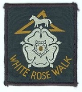
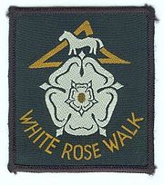
Walkers who complete the walk within a 24 hour period can claim a woven badge and a small certificate.
North Yorkshire
North Yorkshire is a non-metropolitan or shire county located in the Yorkshire and the Humber region of England, and a ceremonial county primarily in that region but partly in North East England. Created in 1974 by the Local Government Act 1972 it covers an area of , making it the largest...
, England
England
England is a country that is part of the United Kingdom. It shares land borders with Scotland to the north and Wales to the west; the Irish Sea is to the north west, the Celtic Sea to the south west, with the North Sea to the east and the English Channel to the south separating it from continental...
, was devised in 1968 by the Yorkshire Wayfarers, It starts at the Kilburn White Horse
Kilburn White Horse
The Kilburn white horse, , is a hill figure formed in the hillside near the village of Kilburn, in North Yorkshire, England. The horse is long by high and covers about and is said to be the largest and most northerly in England....
(National Grid Ref SE 514 813) and is completed by touching the trig point on top of Roseberry Topping
Roseberry Topping
Roseberry Topping is a distinctive hill on the border between North Yorkshire and the borough of Redcar and Cleveland, England. It is situated near Great Ayton and Newton under Roseberry. Its summit has a distinctive half-cone shape with a jagged cliff, which has led to many comparisons with the...
(NZ 579 126). The walk whilst recognised by the Long Distance Walkers Association
Long Distance Walkers Association
The Long Distance Walkers Association is a British association whose aim is "to further the common interests of those who enjoy Long Distance Walking". It was established in 1972 and has over 6,000 members...
(LDWA) as a long distance walk in itself , mixes and crosses with several other long distance paths including the Cleveland Way
Cleveland Way
The Cleveland Way is a National Trail in ancient Cleveland in Northern England. It runs 110 miles from Helmsley to Filey, skirting the North York Moors National Park.-History:The trail was opened in 1969...
, the Coast to Coast Walk
Coast to Coast Walk
The Coast to Coast Walk is a 192-mile unofficial and mostly unsignposted long distance footpath in Northern England...
, and the Lyke Wake Walk
Lyke Wake Walk
The Lyke Wake Walk was started by a local farmer, Bill Cowley, in the North Riding of Yorkshire, England, in 1955. He claimed that one could walk over the North York Moors from east to west on heather all the way except for crossing one or two roads and he issued a challenge that walkers took up...
. The route takes in the highest peaks in the area such as Live Moor, Carlton Moor, Sutton Bank
Sutton Bank
Sutton Bank, also known as Roulston Scar, is a hill in the Hambleton District of North Yorkshire in England. It is a high point on the Hambleton Hills and the North Yorkshire Moors with extensive views over the Vale of York and the Vale of Mowbray...
, Cold Moor, the Wainstones and Urra Moor
Urra Moor
Urra Moor is the highest moor in the North York Moors at 454 metres above sea level, in the national park in North Yorkshire, England. The name applies to the moor as a whole; the summit itself is known as Round Hill....
. The walk also passes the Captain Cook Monument on Easby Moor
Easby Moor
Easby Moor is a hill in the North York Moors at above sea level, in the national park in North Yorkshire, England. It overlooks the village of Great Ayton....
.
The walk takes in not only stunning scenery with grand views of the Vale of York
Vale of York
The Vale of York is an area of flat land in the north-east of England. The vale is a major agricultural area and serves as the main north-south transport corridor for northern England....
but also takes the walker through Yorkshire's history, passing by Bronze Age
Bronze Age
The Bronze Age is a period characterized by the use of copper and its alloy bronze as the chief hard materials in the manufacture of some implements and weapons. Chronologically, it stands between the Stone Age and Iron Age...
ancient burial mounds, the site of 18th Century horse racing and Hambleton Drove Road where cattle were taken to market in Yorkshire, Derbyshire
Derbyshire
Derbyshire is a county in the East Midlands of England. A substantial portion of the Peak District National Park lies within Derbyshire. The northern part of Derbyshire overlaps with the Pennines, a famous chain of hills and mountains. The county contains within its boundary of approx...
and Lincolnshire
Lincolnshire
Lincolnshire is a county in the east of England. It borders Norfolk to the south east, Cambridgeshire to the south, Rutland to the south west, Leicestershire and Nottinghamshire to the west, South Yorkshire to the north west, and the East Riding of Yorkshire to the north. It also borders...
by Scottish and Northumbrian drovers
Droving
Droving is the practice of moving livestock over large distances by walking them "on the hoof".Droving stock to market, usually on foot and often with the aid of dogs, has a very long history in the old world...
.
Walkers who complete the walk within a 24 hour period can claim a woven badge and a small certificate.
Route
- White Horse KilburnKilburn White HorseThe Kilburn white horse, , is a hill figure formed in the hillside near the village of Kilburn, in North Yorkshire, England. The horse is long by high and covers about and is said to be the largest and most northerly in England....
- 515813 - View Point Sutton BankSutton BankSutton Bank, also known as Roulston Scar, is a hill in the Hambleton District of North Yorkshire in England. It is a high point on the Hambleton Hills and the North Yorkshire Moors with extensive views over the Vale of York and the Vale of Mowbray...
- 514828 - Sneck Yate Bank - 508875
- High Paradise Farm - 504887
- Whitestones - 491931
- Minor Road - 479959
- Picnic area near Moor - 470993
- Carlton BankCarlton BankCarlton Bank is a hill in the Cleveland Hills, in north-east England. It is located on Carlton Moor in the North York Moors and overlooks the villages of Carlton-in-Cleveland and Faceby. The summit provides extensive views of Teesside including Middlesbrough and Redcar to the north as well as the...
- 522030 - Picnic Area Hasty BankHasty BankHasty Bank is a hill in the Cleveland Hills range of the North York Moors, in north-east England. The Cleveland Way National Trail crosses Hasty Bank and is part of Wainwright's Coast to Coast Walk. The north face of Hasty Bank has heavily eroded, possessing a vertical rocky face sloping steeply...
- 572035 - Incline top - Railway - 611025
- T - Junction KildaleKildaleKildale is a village and civil parish in Hambleton district of North Yorkshire, England. It lies approximately 3 miles south-east of Great Ayton, in the North Yorkshire Moors on the Cleveland Way National Trail....
- 605092 - Captain Cook Monument - 590101
- Roseberry ToppingRoseberry ToppingRoseberry Topping is a distinctive hill on the border between North Yorkshire and the borough of Redcar and Cleveland, England. It is situated near Great Ayton and Newton under Roseberry. Its summit has a distinctive half-cone shape with a jagged cliff, which has led to many comparisons with the...
- 579126 - END T - Junction at NewtonNewton under RoseberryNewton under Roseberry is a village in the borough of Redcar and Cleveland and the ceremonial county of North Yorkshire, England. It is on the A173, between Great Ayton and Guisborough and is close to the base of Roseberry Topping....
- 571128