

Whau River
Encyclopedia
Waitemata Harbour
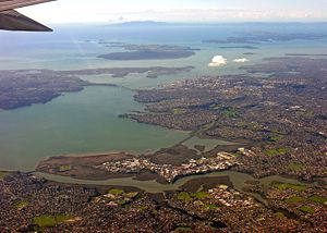
The quite famous Waitemata Harbour is the main access by sea to Auckland, New Zealand. For this reason it is often referred to as Auckland Harbour, despite the fact that it is only one of two harbours surrounding the city, and is crossed by the Auckland Harbour Bridge. The Waitemata forms the north...
(rather than a river) within the Auckland
Auckland
The Auckland metropolitan area , in the North Island of New Zealand, is the largest and most populous urban area in the country with residents, percent of the country's population. Auckland also has the largest Polynesian population of any city in the world...
metropolitan area in New Zealand
New Zealand
New Zealand is an island country in the south-western Pacific Ocean comprising two main landmasses and numerous smaller islands. The country is situated some east of Australia across the Tasman Sea, and roughly south of the Pacific island nations of New Caledonia, Fiji, and Tonga...
. It flows north for 5.7 kilometres from its origin at the confluence of the Avondale Stream and Whau Stream to its mouth between the Te Atatu
Te Atatu
Te Atatu is the name of two suburbs in western Auckland, New Zealand: Te Atatu Peninsula and Te Atatu South. They are located next to each other some 10 kilometres to the west of the Auckland city centre....
peninsula and the long, thin Rosebank Peninsula
Rosebank, Auckland
Rosebank is a peninsula and industrial suburb of Auckland City, New Zealand, forming the westernmost part of the city at the edge to Waitakere City, and jutting out into the Waitemata Harbour....
in Avondale
Avondale, Auckland
Avondale is a suburb of Auckland, New Zealand, located in the Whau ward, one of the thirteen administrative divisions for the Auckland Council. It is commonly considered to be part of West Auckland. It was originally called "Te Whau", which is the common name, of Māori origin, for Entelea...
. It is 800 metres at its widest and 400 metres wide at its mouth.
The estuary extends past the suburbs of Glendene
Glendene, New Zealand
Glendene is an Auckland suburb. It is under the local governance of the Waitakere City Council.Glendene School and community arts college is a special needs school in the north-east of England in a village called Easington, County Durham....
and Kelston
Kelston, New Zealand
Kelston is a residential suburb of Waitakere, one of the four cities that make up the Auckland metropolitan area in northern New Zealand. At the 2001 census, it has a population of 3,975....
, between Auckland City
Auckland City
Auckland City was the city and local authority covering the Auckland isthmus and most of the islands of the Hauraki Gulf, in the North Island of New Zealand. On 1 November 2010 it was amalgamated into the wider Auckland Region under the authority of the new Auckland Council...
to the east and Waitakere City to the west. It has one small estuarial tributary arm, the Wairau Creek in the southwest. The tide flows up the Wairau Creek as far as Sabulite Road in Kelston, and up the Rewarewa Creek to Clark Street and Wolverton Road in New Lynn
New Lynn, New Zealand
New Lynn is a residential suburb, located in the former Waitakere City, one of the four main urbanised regions that have since become the city of Auckland, in northern New Zealand.The population was 15,510 in the 2006 Census, an increase of 1,446 from 2001....
.
The area around the mouth of the estuary is protected as the Motu Manawa (Pollen Island) Marine Reserve
Motu Manawa (Pollen Island) Marine Reserve
Motu Manawa Marine Reserve is a protected area in the Waitemata Harbour in New Zealand. It is intersected by State Highway 16 and contains Pollen and Traherne Islands. The marine reserve was established in 1995.-External links:...
. Pollen Island
Pollen Island
Pollen Island is one of two islands contained within the Motu Manawa Marine Reserve, which is a protected area in the Waitemata Harbour in New Zealand. The other island is Traherne Island.The marine reserve was established in 1995...
(Motu Manawa in Maori
Maori language
Māori or te reo Māori , commonly te reo , is the language of the indigenous population of New Zealand, the Māori. It has the status of an official language in New Zealand...
) and the nearby small Traherne Island
Traherne Island
Traherne Island is one of two islands contained within the Motu Manawa Marine Reserve, which is a protected area in the Waitemata Harbour in New Zealand. The other island is Pollen Island. The marine reserve was established in 1995....
, are located at the northern tip of the peninsula. Traherne Island is connected to the mainland by causeways and bridges that are part of State Highway 16
New Zealand State Highway network
The New Zealand State Highway network is the major national highway network in New Zealand. Just under 100 roads in both the North and South Islands are State Highways...
.
The Whau River is named after a native tree, the whau
Entelea
Entelea arborescens or whau is a species of malvaceous tree endemic to New Zealand. E. arborescens is the only species in the genus Entelea. A shrub or small tree to 6 m with large lime-like leaves giving a tropical appearance, whau grows in low forest along the coast of the North Island and...
(Entelea arborescens).
History
In earlier times, Maori used the Whau for travel between the Waitemata Harbour (on the PacificPacific Ocean
The Pacific Ocean is the largest of the Earth's oceanic divisions. It extends from the Arctic in the north to the Southern Ocean in the south, bounded by Asia and Australia in the west, and the Americas in the east.At 165.2 million square kilometres in area, this largest division of the World...
east coast) and the Manukau Harbour
Manukau Harbour
Manukau Harbour is the second largest natural harbour in New Zealand by area. It is located to the southwest of the Auckland isthmus, and is an arm of the Tasman Sea.-Geography:...
(on the Tasman
Tasman Sea
The Tasman Sea is the large body of water between Australia and New Zealand, approximately across. It extends 2,800 km from north to south. It is a south-western segment of the South Pacific Ocean. The sea was named after the Dutch explorer Abel Janszoon Tasman, the first recorded European...
west coast). They paddled canoe
Waka (canoe)
Waka are Māori watercraft, usually canoes ranging in size from small, unornamented canoes used for fishing and river travel, to large decorated war canoes up to long...
s up the Whau and the Avondale Stream and then carried the canoes over a short stretch of land to Green Bay
Green Bay, New Zealand
Green Bay is an Auckland suburb. It is under the local governance of the Waitakere City Council.The population was 3,936 in the 2006 Census, an increase of 321 from 2001....
on the Manukau. This is remembered in the name for Portage Road, which runs alongside the Avondale Stream, and it is known that seasonal Maori settlements existed at the mouth of the river. For many years after European settlement, there was talk of making a canal
Canal
Canals are man-made channels for water. There are two types of canal:#Waterways: navigable transportation canals used for carrying ships and boats shipping goods and conveying people, further subdivided into two kinds:...
between the Whau and the Manukau.
European settlers used the Whau for marine transport and by 1865 there were five public wharves at New Lynn. Boats carried the products of local industries including brickworks
Brickworks
A brickworks also known as a brick factory, is a factory for the manufacturing of bricks, from clay or shale. Usually a brickworks is located on a clay bedrock often with a quarry for clay on site....
, a leather tannery, a gelatine and glue factory and firewood cutting. The last commercial vessel to use the Whau was a flat-bottomed scow
Scow
A scow, in the original sense, is a flat-bottomed boat with a blunt bow, often used to haul bulk freight; cf. barge. The etymology of the word is from the Dutch schouwe, meaning such a boat.-Sailing scows:...
the Rahiri, which carried bricks and manuka
Leptospermum scoparium
Leptospermum scoparium is a shrub or small tree native to New Zealand and southeast Australia. Evidence suggests that L. scoparium originated in Australia before the onset of the Miocene aridity and dispersed relatively recently from Eastern Australia to New Zealand. It is likely that on arrival...
firewood from the area until 1948. For nearly a hundred years, factories such as the tannery and an abbatoir discharged wastes directly into the Whau.
Friends of the Whau Inc. was formed in 1999 to restore the ecology of the Whau through revegetation and reduction of pollution.
The West End Rowing Club
West End Rowing Club
West End Rowing Club is based at Saunders Reserve, Avondale, Auckland, New Zealand. West End Rowing Club is New Zealand's leading rowing club with a strong, proud history both on and off the water...
has been based on the Whau since 2001.