
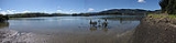
Whangape Harbour
Encyclopedia

New Zealand
New Zealand is an island country in the south-western Pacific Ocean comprising two main landmasses and numerous smaller islands. The country is situated some east of Australia across the Tasman Sea, and roughly south of the Pacific island nations of New Caledonia, Fiji, and Tonga...
. There is a settlement also called Whangape on the northern side of the harbour, and another called Pawarenga on the southern side. The Herekino
Herekino
Herekino is a locality in Northland, New Zealand. It lies 26 km south west of Kaitaia. The Herekino Harbour, also called the Herekino River, is an estuary and inlet from the Tasman Sea to the west...
Harbour and settlement are a few kilometres to the north, and the Hokianga
Hokianga
Hokianga is an area surrounding the Hokianga Harbour, also known as The Hokianga River, a long estuarine drowned valley on the west coast in the north of the North Island of New Zealand....
is to the south and east. Kaitaia
Kaitaia
Kaitaia is a town in the far north region of New Zealand, at the base of the Aupouri Peninsula which is about 160 km northwest of Whangarei. It is the last major settlement on the main road north to the capes and bays on the peninsula...
is 42 km north east.
The harbour is a narrow valley from the confluence of the Awaroa
Awaroa River
The Awaroa River is a short river in the far north of New Zealand. It is located south of Kaitaia, and flows southwest for , reaching the Tasman Sea to the north of the Hokianga Harbour....
and Rotokakahi River
Rotokakahi River
The Rotokakahi River is a river of the Northland Region of New Zealand's North Island. Its winding course is predominantly southwestward from its origins in the Maungataniwha Range. It reaches the Tasman Sea 25 kilometres south of Kaitaia, and its estuary forms one of the two arms of Whangape...
s through hills to the Tasman Sea
Tasman Sea
The Tasman Sea is the large body of water between Australia and New Zealand, approximately across. It extends 2,800 km from north to south. It is a south-western segment of the South Pacific Ocean. The sea was named after the Dutch explorer Abel Janszoon Tasman, the first recorded European...
. The harbour entrance is treacherous.
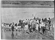
History
According to Māori traditions, the wakaWaka (canoe)
Waka are Māori watercraft, usually canoes ranging in size from small, unornamented canoes used for fishing and river travel, to large decorated war canoes up to long...
Māmari
Mamari
In Māori tradition, Māmari was one of the great ocean-going, voyaging canoes that was used in the migrations that settled New Zealand.Mamari was the 3rd waka to arrive with the tangata Ruanui. The traditions of the Aotea, Horotua and Mamari waka...
, captained by Ruānui, settled the Whangape area after being forced out of the Hokianga during early Māori settlement
Maori migration canoes
Various Māori traditions recount how their ancestors set out from their homeland in great ocean-going canoes . Some of these traditions name a mythical homeland called Hawaiki....
of New Zealand.. They established a large fortified pa
Pa (Maori)
The word pā can refer to any Māori village or settlement, but in traditional use it referred to hillforts fortified with palisades and defensive terraces and also to fortified villages. They first came into being about 1450. They are located mainly in the North Island north of lake Taupo...
at Pawarenga. Here they were attacked by a war party from the south, which greatly outnumbered them. The Ngāti Ruānui stacked brushwood about the pa, and set them alight before fleeing across the harbour on rafts, hidden by the clouds of smoke produced. They settled much of the far north, becoming known as Te Aupōuri
Te Aupouri
Te Aupōuri is the northernmost Māori iwi , located north of Kaitaia, Northland, New Zealand, a region known as the Aupouri Peninsula.-The ancestral legend:...
('au' means current and 'pōuri' smoke) after this event.
Edward Wakefield
Edward Gibbon Wakefield
Edward Gibbon Wakefield was a British politician, the driving force behind much of the early colonisation of South Australia, and later New Zealand....
described the harbour in 1837, and estimated the local Māori population as "not fewer than one thousand souls".
Whangape settlement became an important timber port in the late 19th and early 20th century. There was a large mill on the foreshore and numerous houses on the hills. Ships, initially sailing ships and later steamers, loaded the kauri timber and transported it to markets elsewhere. At least four ships were wrecked at the harbour entrance: the 79-ton schooner Leonidas in 1871, the 15-ton cutter Lionel in 1877 with all five on board lost, the 108 ton schooner Geelong in 1879 with two lives lost, and most recently the River Hunter foundered in 1906 while under tow.
Education
Socio-Economic Decile
Decile, Socio-Economic Decile or Socio-Economic Decile Band is a widely used measure in education in New Zealand used to target funding and support to more needy schools....
of 2 and a roll of 26.
Rotokakahi Native School (also called Rotokakahi Maori School) operated from 1918 to about 1969 on the harbour.