

West Park, Leeds
Encyclopedia
West Park is a suburb of north-west Leeds
, West Yorkshire
, England
, north of Headingley
. It is a mixed area of private suburban housing and suburban council estates. The name derives from its main park (approximately 500 metres north-south by 300 metres east-west) containing playing fields together with a conservation area of grassy meadow ending in woodland. The largest housing estate in West Park is Moor Grange
.
Ward and partly in the Weetwood
Ward of Leeds City Council
. West Park lies in the Leeds North West
parliamentary constituency and is served by Liberal Democrat
MP, Greg Mulholland
. It has the postcode LS16.
. Its boundaries are approximately the A660
Otley Road to the east, the A6120 Leeds Outer Ring Road to the North, the Harrogate Line
railway to the West, and the Queenswood Drive / Spen Lane intersection to the South.
estate around Spen Lane and Butcher Hill, which include: the West Park Centre (an educational facility in the premises of the former West Park High School), Abbey Grange Church of England High School
, St Chad's Church of England Primary School, St Andrew's church which also houses the offices of STEP (Supporting The Elderly People), a doctor's surgery, a post office, a beautician, hair salons, cafés, a Co-op supermarket, newsagents, takeaways, a pet shop, a charity shop, a window and glazing store, a florist, a launderette, and a public house called 'The Dalesman'. Lawnswood School
lies in between West Park and Lawnswood. West Park lies close to Headingley
and Horsforth
which have larger local centres.
and the A65
, with the Leeds Outer Ring Road
running to the north of the area. The Leeds-Harrogate railway line runs through Moor Grange
,but there is no station, the nearest to the south is Headingley
and Horsforth
to the north. Many bus routes run through the area, providing regular services to Leeds city centre
, Headingley
and Horsforth
.
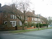 West Park has an area of early 20th century private housing between Otley Road and Spen Lane, mainly large detached and semi detached houses. The streets here are mainly tree-lined and have wide pavements. There are also some older Victorian buildings around Otley Road, some of which have been divided into flats. The houses towards Otley Road are generally older and larger than those towards Spen Lane. The private housing generally lies to the East of West Park, wher it gives way to Far Headingley
to the South and Lawnswood
to the North. Most of the private housing in West Park lie in a Conservation area
.
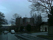 Moor Grange
Estate is a 1950s-built council estate, on reclaimed farm land called 'Old Farm', together with a more affluent estate of predominantly large semi and detached housing between Spen Lane and the A660 Otley Road. The smaller Spen Estate is south of Butcher Hill. The Moor Grange area was used for filming The Beiderbecke Affair
, using the Butcher Hill playing fields and the Clayton Grange flats. The crime rate in and around the Moor Grange and Spen Estates is generally lower than other council estates and house prices are similar to other North Leeds suburbs such as Roundhay
, Oakwood
, Adel
, and Horsforth
.
Leeds
Leeds is a city and metropolitan borough in West Yorkshire, England. In 2001 Leeds' main urban subdivision had a population of 443,247, while the entire city has a population of 798,800 , making it the 30th-most populous city in the European Union.Leeds is the cultural, financial and commercial...
, West Yorkshire
West Yorkshire
West Yorkshire is a metropolitan county within the Yorkshire and the Humber region of England with a population of 2.2 million. West Yorkshire came into existence as a metropolitan county in 1974 after the passage of the Local Government Act 1972....
, England
England
England is a country that is part of the United Kingdom. It shares land borders with Scotland to the north and Wales to the west; the Irish Sea is to the north west, the Celtic Sea to the south west, with the North Sea to the east and the English Channel to the south separating it from continental...
, north of Headingley
Headingley
Headingley is a suburb of Leeds in West Yorkshire, England. It is approximately two miles out of the city centre, to the north west along the A660 road...
. It is a mixed area of private suburban housing and suburban council estates. The name derives from its main park (approximately 500 metres north-south by 300 metres east-west) containing playing fields together with a conservation area of grassy meadow ending in woodland. The largest housing estate in West Park is Moor Grange
Moor Grange
Moor Grange Estate is a housing estate in the West Park area of Leeds, West Yorkshire, England, which was built in the 1950s on reclaimed farmland. Work on the Moor Grange Estate began in 1955. It was originally owned by the local council, and was leased by the council to tenants as a council...
.
Government
West Park lies partly in the KirkstallKirkstall
Kirkstall is a suburb of north-west Leeds, West Yorkshire, England, on the eastern side of the River Aire. To the west is Bramley, to the east is Headingley and to the north is West Park. Kirkstall is around from the city centre and is close to the University of Leeds and Leeds Metropolitan...
Ward and partly in the Weetwood
Weetwood
Weetwood is an area between Headingley and Meanwood in north-west Leeds, West Yorkshire, England. It is bounded on the north by the A6120 , on the west by the A660 , on the east by Meanwood Beck and to the south by Hollin Lane...
Ward of Leeds City Council
Leeds City Council
Leeds City Council is the local authority for the City of Leeds metropolitan district of West Yorkshire, England.-History:The city council was established in 1974, with the first elections being held in advance in 1973...
. West Park lies in the Leeds North West
Leeds North West (UK Parliament constituency)
Leeds North West is a parliamentary constituency in the City of Leeds, West Yorkshire which is represented in the House of Commons of the Parliament of the United Kingdom. It elects one Member of Parliament by the first past the post system of election....
parliamentary constituency and is served by Liberal Democrat
Liberal Democrats
The Liberal Democrats are a social liberal political party in the United Kingdom which supports constitutional and electoral reform, progressive taxation, wealth taxation, human rights laws, cultural liberalism, banking reform and civil liberties .The party was formed in 1988 by a merger of the...
MP, Greg Mulholland
Greg Mulholland
Gregory Thomas Mulholland is a Liberal Democrat politician in the United Kingdom, and is the Member of Parliament for Leeds North West. He was first elected at the 2005 general election, winning the seat from Labour and was re-elected with an increased majority at the 2010 general election. Before...
. It has the postcode LS16.
Geography
The West Park district is approximately four miles north west of Leeds city centreLeeds City Centre
Leeds city centre is the central business district of Leeds, England. It is within the Leeds Central parliamentary constituency, represented by Hilary Benn as MP since a by-election in 1999...
. Its boundaries are approximately the A660
A660 road
The A660 is a major road in West Yorkshire, England that runs from Leeds to Burley-in-Wharfedale where it meets the A65. The A660 is approximately long, and crosses the watershed from Airedale to lower Wharfedale...
Otley Road to the east, the A6120 Leeds Outer Ring Road to the North, the Harrogate Line
Harrogate Line
The Harrogate Line is the name given to a passenger rail service through parts of North Yorkshire and the West Yorkshire Metro area of northern England connecting Leeds to York by way of Harrogate and Knaresborough. The service is operated by Northern Rail, with a few additional workings by East...
railway to the West, and the Queenswood Drive / Spen Lane intersection to the South.
Amenities
The amenities of West Park lie in two main areas, on Otley Road there are several shops, a post office, a laundrette, a specialist runners shop, an estate agency, Indian and Italian restaurants. The main parade of shops on Otley Road has Dutch fronts. There are amenities on the Moor GrangeMoor Grange
Moor Grange Estate is a housing estate in the West Park area of Leeds, West Yorkshire, England, which was built in the 1950s on reclaimed farmland. Work on the Moor Grange Estate began in 1955. It was originally owned by the local council, and was leased by the council to tenants as a council...
estate around Spen Lane and Butcher Hill, which include: the West Park Centre (an educational facility in the premises of the former West Park High School), Abbey Grange Church of England High School
Abbey Grange Church of England High School
Abbey Grange Church of England High School is a secondary school located in West Park, Leeds, West Yorkshire, England. It is the only Church of England aided secondary school in Leeds....
, St Chad's Church of England Primary School, St Andrew's church which also houses the offices of STEP (Supporting The Elderly People), a doctor's surgery, a post office, a beautician, hair salons, cafés, a Co-op supermarket, newsagents, takeaways, a pet shop, a charity shop, a window and glazing store, a florist, a launderette, and a public house called 'The Dalesman'. Lawnswood School
Lawnswood School
Lawnswood School is a state comprehensive school in Leeds, West Yorkshire, England. It has about 1500 male and female pupils, aged 11–18. It is a specialist Maths and Computing College. The sixth form was deemed extremely good in the most recent Ofsted inspection in 2009, however the...
lies in between West Park and Lawnswood. West Park lies close to Headingley
Headingley
Headingley is a suburb of Leeds in West Yorkshire, England. It is approximately two miles out of the city centre, to the north west along the A660 road...
and Horsforth
Horsforth
Horsforth is a town and civil parish within the metropolitan borough of the City of Leeds, in West Yorkshire, England, lying to the north west of Leeds. It has a population of 18,928....
which have larger local centres.
Transport
West Park is between the A660A660 road
The A660 is a major road in West Yorkshire, England that runs from Leeds to Burley-in-Wharfedale where it meets the A65. The A660 is approximately long, and crosses the watershed from Airedale to lower Wharfedale...
and the A65
A65 road
The A65 is a major road in England. It runs north west from Leeds in Yorkshire via Kirkstall, Horsforth, Yeadon, Guiseley, Ilkley and Skipton, passes west of Settle, then continues through Ingleton and Kirkby Lonsdale before terminating at Kendal in Cumbria....
, with the Leeds Outer Ring Road
Leeds Outer Ring Road
The Leeds Outer Ring Road is a main road that runs around most of the perimeter of the city of Leeds, West Yorkshire, England. The ring road is approximately long and consists of single and dual carriageways....
running to the north of the area. The Leeds-Harrogate railway line runs through Moor Grange
Moor Grange
Moor Grange Estate is a housing estate in the West Park area of Leeds, West Yorkshire, England, which was built in the 1950s on reclaimed farmland. Work on the Moor Grange Estate began in 1955. It was originally owned by the local council, and was leased by the council to tenants as a council...
,but there is no station, the nearest to the south is Headingley
Headingley railway station
Headingley railway station is off Kirkstall Lane in Leeds, West Yorkshire, England on the Harrogate Line north west of Leeds...
and Horsforth
Horsforth railway station
Horsforth railway station is a railway station in West Yorkshire, England. It is on the Harrogate Line north west of Leeds station and the final stop in the Metro regulated area towards Harrogate...
to the north. Many bus routes run through the area, providing regular services to Leeds city centre
Leeds City Centre
Leeds city centre is the central business district of Leeds, England. It is within the Leeds Central parliamentary constituency, represented by Hilary Benn as MP since a by-election in 1999...
, Headingley
Headingley
Headingley is a suburb of Leeds in West Yorkshire, England. It is approximately two miles out of the city centre, to the north west along the A660 road...
and Horsforth
Horsforth
Horsforth is a town and civil parish within the metropolitan borough of the City of Leeds, in West Yorkshire, England, lying to the north west of Leeds. It has a population of 18,928....
.
Housing
Far Headingley
Far Headingley is an area of Leeds, West Yorkshire, England approximately 3 miles north of the city centre. The parish of Far Headingley was created in 1868....
to the South and Lawnswood
Lawnswood
Lawnswood is a small suburb in the north west of the city of Leeds in West Yorkshire, England. As such it is north north east of the West Yorkshire Urban Area.- Location :It is bordered by West Park, Adel, Ireland Wood and Holt Park...
to the North. Most of the private housing in West Park lie in a Conservation area
Conservation area
A conservation areas is a tract of land that has been awarded protected status in order to ensure that natural features, cultural heritage or biota are safeguarded...
.
Moor Grange
Moor Grange Estate is a housing estate in the West Park area of Leeds, West Yorkshire, England, which was built in the 1950s on reclaimed farmland. Work on the Moor Grange Estate began in 1955. It was originally owned by the local council, and was leased by the council to tenants as a council...
Estate is a 1950s-built council estate, on reclaimed farm land called 'Old Farm', together with a more affluent estate of predominantly large semi and detached housing between Spen Lane and the A660 Otley Road. The smaller Spen Estate is south of Butcher Hill. The Moor Grange area was used for filming The Beiderbecke Affair
The Beiderbecke Affair
The Beiderbecke Affair is a television series produced in the UK by ITV during 1985, written by the prolific Alan Plater, whose lengthy credits to British Television since the 1960s included the preceding 4 part mini series Get Lost! for ITV in 1981...
, using the Butcher Hill playing fields and the Clayton Grange flats. The crime rate in and around the Moor Grange and Spen Estates is generally lower than other council estates and house prices are similar to other North Leeds suburbs such as Roundhay
Roundhay
Roundhay is a large suburb and City Council ward of north-east Leeds, West Yorkshire, England, largely within the LS8 postcode. The ward boundary is the A6120 ring road on the north and the A58 Wetherby Road on the south and east. The boundary follows Gledhow Valley Road to the west before heading...
, Oakwood
Oakwood
-Places:in Canada*Oakwood, Ontario*Oakwood-Vaughan, Toronto, Ontario, a neighbourhood**Oakwood Collegiate Institute, a public high school in the southern end of the Oakwood-Vaughan neighbourhoodin the United Kingdom...
, Adel
Adel
- Places :* Adel, Leeds, West Yorkshire, England* Adel, Georgia, United States* Adel, Iowa, United States* Adel Township, Dallas County, Iowa, United States* Adel, Oregon, United States* Al-Adel, a district of Baghdad, Iraq- Other uses :...
, and Horsforth
Horsforth
Horsforth is a town and civil parish within the metropolitan borough of the City of Leeds, in West Yorkshire, England, lying to the north west of Leeds. It has a population of 18,928....
.
External links
- West Park Residents' Association
- STEP (Supporting The Elderly People)
- West Park Conservation Area Appraisal and Management Plan, approved by Leeds City Council November 2008