
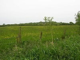
West Moor SSSI, Somerset
Encyclopedia
West Moor is a 213.0 hectare
(526.3 acre) biological Site of Special Scientific Interest on the River Parrett
in Somerset
, notified in 1985.
West Moor lies south of Curry Rivel
, Langport
, and Drayton
, and northwest of Kingsbury Episcopi
and is part of the extensive grazing marsh grasslands and ditch systems of the Somerset Levels
and moors. The site contains some of the most diverse aquatic plant
communities in the country. Rhyne
s often have a rich aquatic flora Frogbit
(Hydrocharis morsus-ranae). A rich invertebrate
fauna
, with many nationally and locally rare species is associated with the botanical diversity of the ditches.
Hectare
The hectare is a metric unit of area defined as 10,000 square metres , and primarily used in the measurement of land. In 1795, when the metric system was introduced, the are was defined as being 100 square metres and the hectare was thus 100 ares or 1/100 km2...
(526.3 acre) biological Site of Special Scientific Interest on the River Parrett
River Parrett
The River Parrett flows through the counties of Dorset and Somerset in South West England, from its source in the Thorney Mills springs in the hills around Chedington in Dorset...
in Somerset
Somerset
The ceremonial and non-metropolitan county of Somerset in South West England borders Bristol and Gloucestershire to the north, Wiltshire to the east, Dorset to the south-east, and Devon to the south-west. It is partly bounded to the north and west by the Bristol Channel and the estuary of the...
, notified in 1985.
West Moor lies south of Curry Rivel
Curry Rivel
Curry Rivel is a village and civil parish in Somerset, England, situated west of Somerton and east of Taunton in the South Somerset district. The parish has a population of 2,093...
, Langport
Langport
Langport is a small town and civil parish in Somerset, England, situated west of Somerton in the South Somerset district. The town has a population of 1,067. The parish includes the hamlets of Bowdens and Combe...
, and Drayton
Drayton, Somerset
Drayton is a village and civil parish in Somerset, England, situated less than a mile from Curry Rivel and five miles southwest of Somerton in the South Somerset district. It is situated on the River Isle, near its confluence with the Parrett, and the former Westport Canal...
, and northwest of Kingsbury Episcopi
Kingsbury Episcopi
Kingsbury Episcopi is a village and civil parish on the River Parrett in Somerset, England, situated north west of Yeovil in the South Somerset district. The village has a population of 1,277. The parish includes the villages of West Lambrook, East Lambrook and Thorney.-History:The "Episcopi"...
and is part of the extensive grazing marsh grasslands and ditch systems of the Somerset Levels
Somerset Levels
The Somerset Levels, or the Somerset Levels and Moors as they are less commonly but more correctly known, is a sparsely populated coastal plain and wetland area of central Somerset, South West England, between the Quantock and Mendip Hills...
and moors. The site contains some of the most diverse aquatic plant
Aquatic plant
Aquatic plants are plants that have adapted to living in aquatic environments. They are also referred to as hydrophytes or aquatic macrophytes. These plants require special adaptations for living submerged in water, or at the water's surface. Aquatic plants can only grow in water or in soil that is...
communities in the country. Rhyne
Rhyne
A rhyne , rhine/rhyne , or reen is a drainage ditch, or canal, used to turn areas of wetland at around sea level into useful pasture....
s often have a rich aquatic flora Frogbit
Hydrocharis morsus-ranae
Hydrocharis morsus-ranae, Frogbit, is a flowering plant belonging to the genus Hydrocharis in the family Hydrocharitaceae. In North America, it is referred to as Common Frogbit or European Frogbit to distinguish it from the related American Frogbit .It is a small floating plant resembling a small...
(Hydrocharis morsus-ranae). A rich invertebrate
Invertebrate
An invertebrate is an animal without a backbone. The group includes 97% of all animal species – all animals except those in the chordate subphylum Vertebrata .Invertebrates form a paraphyletic group...
fauna
Fauna
Fauna or faunæ is all of the animal life of any particular region or time. The corresponding term for plants is flora.Zoologists and paleontologists use fauna to refer to a typical collection of animals found in a specific time or place, e.g. the "Sonoran Desert fauna" or the "Burgess shale fauna"...
, with many nationally and locally rare species is associated with the botanical diversity of the ditches.