
West Los Angeles, Los Angeles, California
Encyclopedia
West Los Angeles is a district in Los Angeles, California
, within a larger region known as the "Westside."
on the west, Brentwood
on the northwest, the unincorporated Sawtelle Veterans Administration grounds on the north, Westwood
on the northeast, Rancho Park
on the east and southeast, and Mar Vista
on the south and southeast. Its generally accepted boundaries are the San Diego Freeway
on the east, the Santa Monica Freeway on the south, the city limits of Santa Monica on the west, and Wilshire Boulevard on the north.
Its major thoroughfares are Olympic
, Santa Monica, Pico
, Wilshire
, and Sawtelle
Boulevards, Barrington and Bundy Drive.
Because the Big Blue Bus
(Santa Monica's municipal bus network) uses UCLA as one of its terminals, it provides good public transit within the region, especially along east-west routes, as does the LACMTA to a lesser extent. However, public transit from West Los Angeles to other, more distant districts within L.A. is poor.
This district contains an area of Japanese-American culture along Sawtelle Boulevard which is sometimes called Sawtelle.
. With the arrival of Anglo settlers after the Mexican-American War, the original Californio
landowners sold out, or were forced from their holdings, and by the beginning of the 20th century the area was mostly bean and wheat fields. Many Japanese immigrants settled in the district, establishing orchards and nurseries in the process. Some of these nurseries are still in business today, along the stretch of Sawtelle Boulevard between Olympic
and Santa Monica Boulevards.
The core of what is now West Los Angeles, including the West Los Angeles government center at Santa Monica and Purdue, was incorporated as the City of Sawtelle. In the 1920s, West L.A. was annexed by the City of Los Angeles. On December 14, 1980, one of the worst crime sprees in the city's history occurred at La Cienga Blvd's Bob's Big Boy restaurant, in which 11 people were forced into a meat locker-freezer at gunpoint by robbers who shot four to death and left four others wounded. The ABC
telefilm The Right of the People (1986) was said to have been based on this event.
s "Mapping L.A." project supplied these "West Los Angeles" neighborhood statistics: population: 12,659; median household income: $86,403.
UPDATE: As of November 2009, the neighborhood designated by the Los Angeles Times Mapping L.A. project as "West Los Angeles" no longer conforms to any of the boundaries described in this article, so the demographic statistics listed above are no longer relevant to this article. The Mapping project uses the name "West Los Angeles" to refer to an entirely different area lying east of the San Diego Freeway that is commonly regarded as the southern part of the Westwood neighborhood. For the area described in this article, the Mapping project uses the name Sawtelle. The Mapping project does not provide an explanation of why it uses "West Los Angeles" in a way that conflicts both with the historical understanding of this name and with its current usage by organizations such as the West Los Angeles Neighborhood Council, which defines "West Los Angeles" with the same boundaries as indicated above in this article.
, one of the most prominent Reform Jewish
congregations in Southern California, occupies the northeast corner of Olympic and Barrington.
Housing in West Los Angeles is a mixture of low-rise apartment buildings, mostly inhabited by young professionals and working-class families, and single-story tract house developments built between late 1920 and 1960. Two of Los Angeles's tallest residential towers are at the neighborhood's northern edge, at the intersection of Wilshire and Barrington. There is a trend toward greater density, as single-family houses get replaced by apartment buildings, or apartment buildings by taller ones, as building sites become available through demolition.
 Schools in the area, such as Wildwood School, are well-respected and of generally high quality. University High School, a secondary school
named for nearby UCLA
, is in the district. "Uni" is one of very few older high schools in Los Angeles that have not had to be completely rebuilt following earthquakes over the years, and still has a traditional look to it featuring weathered brick walls and arched entries. As a result, it is a popular with film producers as a shooting location, even when school is in session, much to the chagrin of the students and faculty. The campus also contains within its bounds an artesian well
(claimed by the Tongva people as their ancestral home) which has never failed, even in the driest years. Junipero Serra's party is said to have camped there in the course of their journey up and down the state.
West Los Angeles is the home of a Consolidated Mail Outpatient Pharmacy (CMOP). It is part of an initiative by the Department of Veterans Affairs to provide mail order prescriptions to veterans using computerization at strategic locations throughout the United States.
The area is also the home of the FBI
's Los Angeles field office, located in the federal building on Wilshire Boulevard next to the 405
Freeway.
West Los Angeles has a large Hispanic community evident by the authentic Mexican restaurants and a few Mexican shops. Among the area's Latino residents are a large number of immigrants from Oaxaca
.
West Los Angeles also is home to the Flynt Building which hosted the Earth Hour
back in 2008 and also holds Historical significance due to the presence of various Consulates in the building.
SPA 5 West Area Health Office serves West Los Angeles.
operates the West Los Angeles Community Police Station at 1663 Butler Avenue, 90025, serving the neighborhood.
. Neighborhood elementary schools are Brockton Avenue, Nora Sterry Elementary School, and Warner Avenue. Middle schools are Emerson and Webster. High schools are University High School
and Indian Springs Continuation, both on the same site.
, West Los Angeles Baptist School and First Lutheran School of Venice are nearby private schools.
List of Undergraduate and graduate school is Pacific States University
in Harvard Heights area.
operates the West Los Angeles Regional Library.
Los Angeles, California
Los Angeles , with a population at the 2010 United States Census of 3,792,621, is the most populous city in California, USA and the second most populous in the United States, after New York City. It has an area of , and is located in Southern California...
, within a larger region known as the "Westside."
Geography and transportation
The district is bordered by Santa MonicaSanta Monica, California
Santa Monica is a beachfront city in western Los Angeles County, California, US. Situated on Santa Monica Bay, it is surrounded on three sides by the city of Los Angeles — Pacific Palisades on the northwest, Brentwood on the north, West Los Angeles on the northeast, Mar Vista on the east, and...
on the west, Brentwood
Brentwood, Los Angeles, California
Brentwood is a district in western Los Angeles, California, United States. The district is located at the base of the Santa Monica Mountains, bounded by the San Diego Freeway on the east, Wilshire Boulevard on the south, the Santa Monica city limits on the southwest, the border of Topanga State...
on the northwest, the unincorporated Sawtelle Veterans Administration grounds on the north, Westwood
Westwood, Los Angeles, California
Westwood is a neighborhood on the Westside of Los Angeles, California, United States. It is the home of the University of California, Los Angeles .-History:...
on the northeast, Rancho Park
Rancho Park, Los Angeles, California
Rancho Park is a small residential neighborhood in West Los Angeles, California with mostly single family homes and tree lined streets. The community is nestled between Westwood and Cheviot Hills. This enclave draws young professionals and families and is home to residents working in a variety of...
on the east and southeast, and Mar Vista
Mar Vista, Los Angeles, California
Mar Vista is a district on the West Side of Los Angeles, California.-Geography and transportation:Mar Vista is near the center of LA's West Side. The city of Santa Monica lies to the northwest, West Los Angeles to the north, Palms to the northeast, Culver City to the east, Del Rey to the southwest,...
on the south and southeast. Its generally accepted boundaries are the San Diego Freeway
Interstate 405 (California)
Interstate 405 is a major north–south Interstate Highway in Southern California. It is a bypass of Interstate 5, running along the western areas of the Greater Los Angeles Area from Irvine in the south to near San Fernando in the north...
on the east, the Santa Monica Freeway on the south, the city limits of Santa Monica on the west, and Wilshire Boulevard on the north.
Its major thoroughfares are Olympic
Olympic Boulevard
Olympic Boulevard is a major arterial road in Los Angeles, California. It stretches from 4th Street on the western end of Santa Monica to East Los Angeles—farther than Wilshire Boulevard and most other streets....
, Santa Monica, Pico
Pico Boulevard
Pico Boulevard is a major Los Angeles street that runs from the Pacific Ocean at Appian Way in Santa Monica to Central Avenue in Downtown Los Angeles, California, USA...
, Wilshire
Wilshire Boulevard
Wilshire Boulevard is one of the principal east-west arterial roads in Los Angeles, California, United States. It was named for Henry Gaylord Wilshire , an Ohio native who made and lost fortunes in real estate, farming, and gold mining. Henry Wilshire initiated what was to become Wilshire...
, and Sawtelle
Sawtelle Boulevard
Sawtelle Boulevard is a north/south street in Los Angeles, California of important cultural significance. Sawtelle Blvd's northern end is at Ohio Avenue adjacent to the Veteran Administration, and its southern end is at Overland Avenue, a few blocks past Sepulveda Boulevard...
Boulevards, Barrington and Bundy Drive.
Because the Big Blue Bus
Big Blue Bus
Santa Monica Municipal Bus Lines, more commonly known as the Big Blue Bus, is a municipal bus operator in the Westside region of Los Angeles, providing both local and bus rapid transit service in Santa Monica and adjacent neighborhoods of Los Angeles...
(Santa Monica's municipal bus network) uses UCLA as one of its terminals, it provides good public transit within the region, especially along east-west routes, as does the LACMTA to a lesser extent. However, public transit from West Los Angeles to other, more distant districts within L.A. is poor.
This district contains an area of Japanese-American culture along Sawtelle Boulevard which is sometimes called Sawtelle.
History
After the area's colonization by the Spanish, most of what is now West Los Angeles became part of the Rancho San Vicente y Santa MonicaRancho San Vicente y Santa Monica
Rancho San Vicente y Santa Monica was a Mexican land grant in present day Los Angeles County, California given by governor Juan Alvarado in 1839 to Francisco Sepulveda soldier and citizen of Los Angeles...
. With the arrival of Anglo settlers after the Mexican-American War, the original Californio
Californio
Californio is a term used to identify a Spanish-speaking Catholic people, regardless of race, born in California before 1848...
landowners sold out, or were forced from their holdings, and by the beginning of the 20th century the area was mostly bean and wheat fields. Many Japanese immigrants settled in the district, establishing orchards and nurseries in the process. Some of these nurseries are still in business today, along the stretch of Sawtelle Boulevard between Olympic
Olympic Boulevard
Olympic Boulevard is a major arterial road in Los Angeles, California. It stretches from 4th Street on the western end of Santa Monica to East Los Angeles—farther than Wilshire Boulevard and most other streets....
and Santa Monica Boulevards.
The core of what is now West Los Angeles, including the West Los Angeles government center at Santa Monica and Purdue, was incorporated as the City of Sawtelle. In the 1920s, West L.A. was annexed by the City of Los Angeles. On December 14, 1980, one of the worst crime sprees in the city's history occurred at La Cienga Blvd's Bob's Big Boy restaurant, in which 11 people were forced into a meat locker-freezer at gunpoint by robbers who shot four to death and left four others wounded. The ABC
American Broadcasting Company
The American Broadcasting Company is an American commercial broadcasting television network. Created in 1943 from the former NBC Blue radio network, ABC is owned by The Walt Disney Company and is part of Disney-ABC Television Group. Its first broadcast on television was in 1948...
telefilm The Right of the People (1986) was said to have been based on this event.
Demographics
In 2009, the Los Angeles TimesLos Angeles Times
The Los Angeles Times is a daily newspaper published in Los Angeles, California, since 1881. It was the second-largest metropolitan newspaper in circulation in the United States in 2008 and the fourth most widely distributed newspaper in the country....
s "Mapping L.A." project supplied these "West Los Angeles" neighborhood statistics: population: 12,659; median household income: $86,403.
UPDATE: As of November 2009, the neighborhood designated by the Los Angeles Times Mapping L.A. project as "West Los Angeles" no longer conforms to any of the boundaries described in this article, so the demographic statistics listed above are no longer relevant to this article. The Mapping project uses the name "West Los Angeles" to refer to an entirely different area lying east of the San Diego Freeway that is commonly regarded as the southern part of the Westwood neighborhood. For the area described in this article, the Mapping project uses the name Sawtelle. The Mapping project does not provide an explanation of why it uses "West Los Angeles" in a way that conflicts both with the historical understanding of this name and with its current usage by organizations such as the West Los Angeles Neighborhood Council, which defines "West Los Angeles" with the same boundaries as indicated above in this article.
The neighborhood today
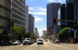
As with most parts of the Westside, West Los Angeles is an affluent neighborhood. Its central location has made it a locus of commercial development, with several high-rise office buildings along Olympic, Santa Monica, and Wilshire Boulevards. It also contains a large number of Japanese-owned businesses. A satellite congregation of the Wilshire Boulevard TempleWilshire Boulevard Temple
Wilshire Boulevard Temple, founded in 1862 as Congregation B'nai B'rith, is the oldest Jewish congregation in Los Angeles, California. One of the country’s most respected Reform congregations, Wilshire Boulevard Temple's magnificent sanctuary, with its iconic dome and Warner Murals, is a City of...
, one of the most prominent Reform Jewish
Reform Judaism
Reform Judaism refers to various beliefs, practices and organizations associated with the Reform Jewish movement in North America, the United Kingdom and elsewhere. In general, it maintains that Judaism and Jewish traditions should be modernized and should be compatible with participation in the...
congregations in Southern California, occupies the northeast corner of Olympic and Barrington.
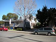
Housing in West Los Angeles is a mixture of low-rise apartment buildings, mostly inhabited by young professionals and working-class families, and single-story tract house developments built between late 1920 and 1960. Two of Los Angeles's tallest residential towers are at the neighborhood's northern edge, at the intersection of Wilshire and Barrington. There is a trend toward greater density, as single-family houses get replaced by apartment buildings, or apartment buildings by taller ones, as building sites become available through demolition.
Secondary school
Secondary school is a term used to describe an educational institution where the final stage of schooling, known as secondary education and usually compulsory up to a specified age, takes place...
named for nearby UCLA
University of California, Los Angeles
The University of California, Los Angeles is a public research university located in the Westwood neighborhood of Los Angeles, California, USA. It was founded in 1919 as the "Southern Branch" of the University of California and is the second oldest of the ten campuses...
, is in the district. "Uni" is one of very few older high schools in Los Angeles that have not had to be completely rebuilt following earthquakes over the years, and still has a traditional look to it featuring weathered brick walls and arched entries. As a result, it is a popular with film producers as a shooting location, even when school is in session, much to the chagrin of the students and faculty. The campus also contains within its bounds an artesian well
Serra Springs (California)
Serra Springs is California State Historical Landmark number 522, and is located on the campus of University High School in Los Angeles County, USA. The springs, called Kuruvungna by the native Gabrieleno Tongva people, were used as natural fresh water source by the Tongva people since the 5th...
(claimed by the Tongva people as their ancestral home) which has never failed, even in the driest years. Junipero Serra's party is said to have camped there in the course of their journey up and down the state.
West Los Angeles is the home of a Consolidated Mail Outpatient Pharmacy (CMOP). It is part of an initiative by the Department of Veterans Affairs to provide mail order prescriptions to veterans using computerization at strategic locations throughout the United States.
The area is also the home of the FBI
Federal Bureau of Investigation
The Federal Bureau of Investigation is an agency of the United States Department of Justice that serves as both a federal criminal investigative body and an internal intelligence agency . The FBI has investigative jurisdiction over violations of more than 200 categories of federal crime...
's Los Angeles field office, located in the federal building on Wilshire Boulevard next to the 405
Interstate 405 (California)
Interstate 405 is a major north–south Interstate Highway in Southern California. It is a bypass of Interstate 5, running along the western areas of the Greater Los Angeles Area from Irvine in the south to near San Fernando in the north...
Freeway.
West Los Angeles has a large Hispanic community evident by the authentic Mexican restaurants and a few Mexican shops. Among the area's Latino residents are a large number of immigrants from Oaxaca
Oaxaca
Oaxaca , , officially Estado Libre y Soberano de Oaxaca is one of the 31 states which, along with the Federal District, comprise the 32 federative entities of Mexico. It is divided into 571 municipalities; of which 418 are governed by the system of customs and traditions...
.
West Los Angeles also is home to the Flynt Building which hosted the Earth Hour
Earth Hour
Earth Hour is a global event organized by WWF and is held on the last Saturday of March annually, asking households and businesses to turn off their non-essential lights and other electrical appliances for one hour to raise awareness towards the need to take action on climate change...
back in 2008 and also holds Historical significance due to the presence of various Consulates in the building.
Government and infrastructure
The Los Angeles County Department of Health ServicesLos Angeles County Department of Health Services
Health services to over 10 million residents in the Los Angeles County are provided by the Los Angeles County Department of Health Services and the Los Angeles County Department of Public Health. Mental health services are provided by the County Department of Mental Health...
SPA 5 West Area Health Office serves West Los Angeles.
Police service
Los Angeles Police DepartmentLos Angeles Police Department
The Los Angeles Police Department is the police department of the city of Los Angeles, California. With just under 10,000 officers and more than 3,000 civilian staff, covering an area of with a population of more than 4.1 million people, it is the third largest local law enforcement agency in...
operates the West Los Angeles Community Police Station at 1663 Butler Avenue, 90025, serving the neighborhood.
Education
Public schools
West Los Angeles is part of the Los Angeles Unified School DistrictLos Angeles Unified School District
Los Angeles Unified School District is the largest public school system in California. It is the 2nd largest public school district in the United States. Only the New York City Department of Education has a larger student population...
. Neighborhood elementary schools are Brockton Avenue, Nora Sterry Elementary School, and Warner Avenue. Middle schools are Emerson and Webster. High schools are University High School
University High School (Los Angeles)
University Senior High School, commonly known as Uni, is a secondary school located in West Los Angeles, a district in Los Angeles, California, United States near the border of Santa Monica. University High is a part of the Los Angeles Unified School District . The campus also holds Indian Springs...
and Indian Springs Continuation, both on the same site.
Private schools
St. Sebastian School, Notre Dame AcademyNotre Dame Academy (Los Angeles, California)
Notre Dame Academy Girls' High School is a private, all-girls Catholic High School located in West Los Angeles, California. Part of the Roman Catholic Archdiocese of Los Angeles, it was founded in 1949 by the Sisters of Notre Dame.-Academics:...
, West Los Angeles Baptist School and First Lutheran School of Venice are nearby private schools.
List of Undergraduate and graduate school is Pacific States University
Pacific States University
Pacific States University is a private university in Harvard Heights , Los Angeles California, U.S. and member of ACICS . Founded in 1928 as an independent private institution, it has provided a comprehensive education in the fields of business, and computer science to more than 10,000 graduates...
in Harvard Heights area.
Public libraries
The Los Angeles Public LibraryLos Angeles Public Library
The Los Angeles Public Library system serves the residents of Los Angeles, California, United States. With over 6 million volumes, LAPL is one of the largest publicly funded library systems in the world. The system is overseen by a Board of Library Commissioners with five members appointed by the...
operates the West Los Angeles Regional Library.
Parks and recreation
The Stoner Recreation Center is located in West Los Angeles. The center includes barbecue pits, a lighted baseball diamond, lighted outdoor basketball courts, a children's play area, a lighted American football field, an indoor gymnasium without weights and a capacity of 300 people, picnic tables, a lighted soccer (football) field, unlighted tennis courts, and lighted volleyball courts. The Annual Cherry Blossom Festival, co-sponsored by the West Los Angeles Japanese American Community Center, is held at the park.See also
- Los Angeles Times suburban sectionsLos Angeles Times suburban sectionsThe Los Angeles Times suburban sections or zone sections were printed between 1952 and 2001 as adjuncts to the main newspaper to cover the news of and sell advertising space in various parts of Southern California that the Times considered to be in the prime part of its circulation area...
External links
- West Los Angeles Neighborhood Council
- Los Angeles Times, Real Estate section, Neighborly Advice column: "
[ West Los Angeles (neighborhood):In the vicinity of everything in West L.A." (19 Jan 2003)] - Sawtelle Blvd.