
Wautharong
Encyclopedia
Wathaurong, also called the Wada wurrung, are an Indigenous Australian tribe living in the area near Melbourne
, Geelong and the Bellarine Peninsula
. They are part of the Kulin
alliance. The Wathaurong language was spoken by 25 clans south of the Werribee River
and the Bellarine Peninsula
to Streatham
. They were sometimes referred to by Europeans as the Barrabool people.
A headman or tribal leader was called an arweet
. Arweet held the same tribal standing as a ngurungaeta
of the Wurundjeri
people.
Coastal clans of the Wada Wurrung may have had contact with Lieutenant John Murray
when he charted Indented Head and named Swan Bay. Matthew Flinders
met several Wada Wurrung when he camped at Indented Head and climbed the You Yangs
in May 1802.
founded the colony at Sullivan Bay, Victoria
in October 1803, he sent Lieutenant J Tuckey to survey and explore Corio Bay
which resulted in several aborigines being shot and wounded. William Buckley
, a convict, escaped from the abortive Sullivan Bay settlement in December 1803, and was adopted by the Wada wurrung balug as they thought he was the resurrected Murrangurk, an important former leader. Buckley lived with this community for 32 years, between 1803 and 1835, before making contact with John Batman
's expedition on 6 July 1835.
The European settlement of Wada wurrung territory began in earnest from 1835 with a rapid arrival of squatters around the Geelong area and westwards. Settlement was marked by resistance to the invasion often by driving off or stealing sheep which then resulted in conflict and sometimes a massacre of aboriginal people.
Very few of these reports were acted upon to bring the settlers to court. On the few occasions when this did happen, such as the killing of Woolmudgin on 7 October 1836 where John Whitehead was sent to Sydney for trial, the case was dropped for lack of evidence. At the time aborigines were denied the right to give evidence in courts of law. The incidents listed below are just the cases that have been reported, it is likely other incidents occurred that were never documented officially. Neil Black, a squatter in Western Victoria writing on 9 December 1839 states the prevailing attitude of many settlers:
Table: reported massacres in Wada wurrung territory to 1859
has written on the Aboriginal presence on the Ballarat goldfields in the 1850s noting that while there is no evidence for any direct involvement of Aboriginal people in the events of the Eureka Rebellion in 1854, aboriginal people may be relevant to the Eureka story in situational, contextual and relational ways.
The events of the Eureka Rebellion took place on Wathaurong aboriginal land. Three Wathaurong clans lived in the vicinity of the Eureka diggings: the Burrumbeet baluk at Lakes Burrumbeet and Learmonth, Keyeet baluk, a sub-group of the Burrumbeet baluk, at Mt Buninyong, and the Tooloora baluk, at Mt Warranheip and Lal Lal Creek. There are numerous accounts of aboriginal presence in tha Ballarat area during the 1850s.
The early policing of the Ballarat Goldfields was done by the Native Police Corps
, who enforced the collection of the gold miners licence fee resulting in confrontations between diggers and the Gold Commissioner, considered by some historians such as M. Cannon and Weston Bate as preludes to the 1854 Eureka Rebellion.
There is oral history that local aboriginal people may have looked after some of the children of the Eureka miners after the military storming of the Eureka Stockade and subsequent massacre of miners. Although not corroborated by any written sources, the account has been deemed plausible by Professor Clark.
 Communities consisted of 25 land-owning groups called clans that spoke a related language and were connected through cultural and mutual interests, totems, trading initiatives and marriage ties. Access to land and resources by other clans, was sometimes restricted depending on the state of the resource in question. For example; if a river or creek had been fished regularly throughout the fishing season and fish supplies were down, fishing was limited or stopped entirely by the clan who owned that resource until fish were given a chance to recover. During this time other resources were utilised for food. This ensured the sustained use of the resources available to them. As with most other Kulin territories, penalties such as spearings were enforced upon trespassers. Today, traditional clan locations, language groups and borders are no longer in use and descendants of Wathaurong people live within modern day society, although still preserving much of their culture.
, or clan headman.
to Port Phillip
, the Bellarine Peninsula
, the Otway forests,and northwest to Mount Emu and Mount Misery. Their territory encompassed the Ballarat goldfields.
Melbourne
Melbourne is the capital and most populous city in the state of Victoria, and the second most populous city in Australia. The Melbourne City Centre is the hub of the greater metropolitan area and the Census statistical division—of which "Melbourne" is the common name. As of June 2009, the greater...
, Geelong and the Bellarine Peninsula
Bellarine Peninsula
The Bellarine Peninsula is a peninsula located south-west of Melbourne in Victoria, Australia, surrounded by Port Phillip, Corio Bay and Bass Strait. The peninsula, together with the Mornington Peninsula separates Port Phillip from Bass Strait...
. They are part of the Kulin
Kulin
The Kulin nation, was an alliance of five Indigenous Australian nations in Central Victoria, Australia, prior to European settlement. Their collective territory extended to around Port Phillip and Western Port, up into the Great Dividing Range and the Loddon and Goulburn River valleys. To their...
alliance. The Wathaurong language was spoken by 25 clans south of the Werribee River
Werribee River
The Werribee River is located on the plain west of Melbourne, Victoria, Australia. The headwaters of a tributary, the Lerderderg River, are north of Ballan near Daylesford and it flows across the basalt plain, through the suburb of Werribee to enter Port Phillip. A linear park follows the Werribee...
and the Bellarine Peninsula
Bellarine Peninsula
The Bellarine Peninsula is a peninsula located south-west of Melbourne in Victoria, Australia, surrounded by Port Phillip, Corio Bay and Bass Strait. The peninsula, together with the Mornington Peninsula separates Port Phillip from Bass Strait...
to Streatham
Streatham, Victoria
Streatham is a town in the Western District of Victoria, Australia, located on the Glenelg Highway, west of Ballarat, in the Rural City of Ararat. At the 2006 census, Streatham had a population of 377....
. They were sometimes referred to by Europeans as the Barrabool people.
A headman or tribal leader was called an arweet
Arweet
Arweet is an important tribal position in the Boon wurrung and Wathaurong tribal peoples of the Indigenous Australian Kulin alliance who live from Western Port, Port Phillip, Geelong to Ballarat.An Arweet is a leader or headman and held a similar tribal standing as a ngurungaeta of the Wurundjeri...
. Arweet held the same tribal standing as a ngurungaeta
Ngurungaeta
Ngurungaeta is a Wurundjeri word meaning 'head man' or 'tribal leader'. Ngurungaeta held the same tribal standing as an Arweet of the Bunurong and Wathaurong people...
of the Wurundjeri
Wurundjeri
The Wurundjeri are a people of the Indigenous Australian nation of the Woiwurrung language group, in the Kulin alliance, who occupy the Birrarung Valley, its tributaries and the present location of Melbourne, Australia...
people.
History
The Wathaurong lived in the area for at least the last 25,000 years with 140 archaeological sites having been found in the region, indicating a significant level of activity of the Wathaurong people.Coastal clans of the Wada Wurrung may have had contact with Lieutenant John Murray
John Murray (Australian explorer)
John Murray was a seaman and explorer of Australia. He was the first European to discover Port Phillip, the bay on which the cities of Melbourne and Geelong are situated....
when he charted Indented Head and named Swan Bay. Matthew Flinders
Matthew Flinders
Captain Matthew Flinders RN was one of the most successful navigators and cartographers of his age. In a career that spanned just over twenty years, he sailed with Captain William Bligh, circumnavigated Australia and encouraged the use of that name for the continent, which had previously been...
met several Wada Wurrung when he camped at Indented Head and climbed the You Yangs
You Yangs
The You Yangs are a series of granite ridges that rise to 364m above the Werribee Plain approximately 55km south west of Melbourne and 22km north east of Geelong, in Victoria, Australia. The main ridge runs roughly N-S for about 9 km, with a lower extension running for about 15 km to the west...
in May 1802.
Massacres
When Lieutenant David CollinsDavid Collins (governor)
Colonel David Collins was the first Lieutenant Governor of the Colony of Van Diemens Land, founded in 1804, which in 1901 became the state of Tasmania in the Commonwealth of Australia.-Early life and military career:...
founded the colony at Sullivan Bay, Victoria
Sullivan Bay, Victoria
Sullivan Bay lies 60 km due south of Melbourne on Port Phillip, one kilometre east of Sorrento, Victoria. It was established as a short-lived convict settlement in 1803 by Lieutenant Colonel David Collins. The site was chosen because of its strategic location near the entrance of the Bay...
in October 1803, he sent Lieutenant J Tuckey to survey and explore Corio Bay
Corio Bay
Corio Bay is one of numerous bays in the southwest corner of Australia's Port Phillip, and is the bay on which abuts the City of Geelong. The nearby suburb of Corio takes its name from Corio Bay.-Name:...
which resulted in several aborigines being shot and wounded. William Buckley
William Buckley (convict)
William Buckley was an English convict who was transported to Australia, escaped, was given up for dead and lived in an Aboriginal community for many years....
, a convict, escaped from the abortive Sullivan Bay settlement in December 1803, and was adopted by the Wada wurrung balug as they thought he was the resurrected Murrangurk, an important former leader. Buckley lived with this community for 32 years, between 1803 and 1835, before making contact with John Batman
John Batman
John Batman was an Australian grazier, businessman and explorer who is best known for his role in the founding of a settlement which became Melbourne and the colony of Victoria.-Life:...
's expedition on 6 July 1835.
The European settlement of Wada wurrung territory began in earnest from 1835 with a rapid arrival of squatters around the Geelong area and westwards. Settlement was marked by resistance to the invasion often by driving off or stealing sheep which then resulted in conflict and sometimes a massacre of aboriginal people.
Very few of these reports were acted upon to bring the settlers to court. On the few occasions when this did happen, such as the killing of Woolmudgin on 7 October 1836 where John Whitehead was sent to Sydney for trial, the case was dropped for lack of evidence. At the time aborigines were denied the right to give evidence in courts of law. The incidents listed below are just the cases that have been reported, it is likely other incidents occurred that were never documented officially. Neil Black, a squatter in Western Victoria writing on 9 December 1839 states the prevailing attitude of many settlers:
- "The best way [to procure a run] is to go outside and take up a new run, provided the conscience of the party is sufficiently seared to enable him without remorse to slaughter natives right and left. It is universally and distinctly understood that the chances are very small indeed of a person taking up a new run being able to maintain possession of his place and property without having recourse to such means -- sometimes by wholesale..."
Table: reported massacres in Wada wurrung territory to 1859
| Date | Location | Aborigines involved | Europeans involved | Aboriginal Deaths reported |
|---|---|---|---|---|
| October 1803 | Corio Bay | Wada wurrung, possibly Yaawangi or Wada wurrung balug | Lieutenant J Tuckey and others | two people |
| 17 October 1836 | Barwon River, Barrabool Hills | Wada wurrung balug clan | John Whitehood, encouraged by Frederick Taylor | Woolmudgin alias Curacoine |
| Summer 1837-1838 | Golf Hill Station, Yarrowee River, north of Inverleigh | Wada wurrung clan unknown | A shepherd and a hut keeper, Clyde company employees | two people |
| June 1839-1840 | unknown | Wada wurrung balug clan | soldiers | three people |
| 25 November 1847 | Anderson and Mills Public House, Buninyong | Wada wurrung clan unknown | unknown | two people |
Aboriginal presence on the Ballarat goldfields
Historian Ian D. ClarkIan D. Clark (historian)
Ian D. Clark is an academic historian and Toponymist whose primary work has focused on Victorian Aboriginal history, aboriginal toponymy and the frontier conflict between Indigenous Australians and immigrant settlers during the European settlement of Victoria, Australia.-Education and...
has written on the Aboriginal presence on the Ballarat goldfields in the 1850s noting that while there is no evidence for any direct involvement of Aboriginal people in the events of the Eureka Rebellion in 1854, aboriginal people may be relevant to the Eureka story in situational, contextual and relational ways.
The events of the Eureka Rebellion took place on Wathaurong aboriginal land. Three Wathaurong clans lived in the vicinity of the Eureka diggings: the Burrumbeet baluk at Lakes Burrumbeet and Learmonth, Keyeet baluk, a sub-group of the Burrumbeet baluk, at Mt Buninyong, and the Tooloora baluk, at Mt Warranheip and Lal Lal Creek. There are numerous accounts of aboriginal presence in tha Ballarat area during the 1850s.
The early policing of the Ballarat Goldfields was done by the Native Police Corps
Native Police Corps
An Australian Native Police Corps was first established in 1842 in the Port Phillip District of the Australian colony of New South Wales...
, who enforced the collection of the gold miners licence fee resulting in confrontations between diggers and the Gold Commissioner, considered by some historians such as M. Cannon and Weston Bate as preludes to the 1854 Eureka Rebellion.
There is oral history that local aboriginal people may have looked after some of the children of the Eureka miners after the military storming of the Eureka Stockade and subsequent massacre of miners. Although not corroborated by any written sources, the account has been deemed plausible by Professor Clark.
Structure, Borders and Land Use
Clans
Prior to European settlement, 25 separate clans existed, each with an arweetArweet
Arweet is an important tribal position in the Boon wurrung and Wathaurong tribal peoples of the Indigenous Australian Kulin alliance who live from Western Port, Port Phillip, Geelong to Ballarat.An Arweet is a leader or headman and held a similar tribal standing as a ngurungaeta of the Wurundjeri...
, or clan headman.
| No | Clan Name | Approximate Location |
|---|---|---|
| 1 | Barere barere balug | 'Colac' and 'Mt Bute' stations |
| 2 | Beerekwart balug | Mount Emu |
| 3 | Bengalat balug | Indented Head |
| 4 | Berrejin balug | Unknown |
| 5 | Boro gundidj | Yarrowee River |
| 6 | Burrumbeet gundidj | Lakes Burumbeet and Learmonth |
| 6a | Keyeet balug | Mount Buninyong |
| 7 | Carringum balug | Carngham |
| 8 | Carininje balug | 'Emu Hill' station, Linton's Creek |
| 9 | Corac balug | 'Commeralghip' station, and Kuruc-a-ruc Creek |
| 10 | Corrin corrinjer balug | Carranballac |
| 11 | Gerarlture balug | West of Lake Modewarre |
| 12 | Marpeang balug | Blackwood, Myrniong, and Bacchus Marsh |
| 13 | Mear balug | Unknown |
| 14 | Moijerre balug | Mount Emu Creek |
| 15 | Moner balug | 'Trawalla' station, Mount Emu Creek |
| 16 | Monmart | Unknown |
| 17 | Neerer balug | Between Geelong and the You Yangs (Hovells Ck?) |
| 18 | Pakeheneek balug | Mount Widderin |
| 19 | Peerickelmoon balug | Near Mount Misery |
| 20 | Tooloora balug | Mount Warrenheip, Lal-lal Creek, west branch of Moorabool River. |
| 21 | Woodealloke gundidj | Wardy Yalloak River, south of Kuruc-a-ruc Creek |
| 22 | Wada wurrung balug | Barrabool Hills |
| 23 | Wongerrer balug | Head of Wardy Yalloak River |
| 24 | Worinyaloke balug | West side of Little River |
| 25 | Yaawangi | You Yang Hills |
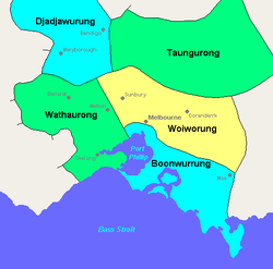
Territory
The Wathaurong territory extended from the southern side of the Werribee RiverWerribee River
The Werribee River is located on the plain west of Melbourne, Victoria, Australia. The headwaters of a tributary, the Lerderderg River, are north of Ballan near Daylesford and it flows across the basalt plain, through the suburb of Werribee to enter Port Phillip. A linear park follows the Werribee...
to Port Phillip
Port Phillip
Port Phillip Port Phillip Port Phillip (also commonly referred to as Port Phillip Bay or (locally) just The Bay, is a large bay in southern Victoria, Australia; it is the location of Melbourne. Geographically, the bay covers and the shore stretches roughly . Although it is extremely shallow for...
, the Bellarine Peninsula
Bellarine Peninsula
The Bellarine Peninsula is a peninsula located south-west of Melbourne in Victoria, Australia, surrounded by Port Phillip, Corio Bay and Bass Strait. The peninsula, together with the Mornington Peninsula separates Port Phillip from Bass Strait...
, the Otway forests,and northwest to Mount Emu and Mount Misery. Their territory encompassed the Ballarat goldfields.