
Watson's Dodd
Encyclopedia
Watson's Dodd is a fell
in the English
Lake District
. It forms part of the Helvellyn range
in the Eastern Fells
. This chain of hills runs north-south and, in the vicinity of Watson's Dodd, forms the watershed between the Thirlmere
and Ullswater
catchments.
while Great Dodd
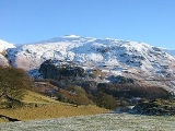
rises to the north. The fell occupies a bend in the ridge, formed by the head of Deepdale on the eastern side. On the western side is a broad grassy flank, difficult to describe as a ridge, falling to the foot of Thirlmere at Legburnthwaite. This is bounded by Stanah Gill to the south and Mill Gill to the north. Rougher ground breaks out as the slope increases at around 1,500 ft, culminating the fell's chief glory, Castle Rock (1,112 ft).
maps is also known as The Castle Rock of Triermain and is an impressive crag overlooking the Vale of St John, north of Thirlmere. It was referred to by Walter Scott
as the setting for his poem The Bridal of Triermain,
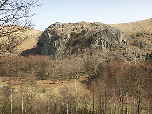 hence the longer romantic name. Jutting out from the hillside it provides faces on three sides, although the top can easily be reached from 'behind'. The castle-like profile is made still more picturesque by a garland of mixed woodland around the lower slopes.
-tuff
of the Thirlmere Member. An outcrop of breccia
lies below this on the western slope. Castle Rock is composed of bedded tuff
s of the Tarn Crags Member.
marks the top, toward the western edge. Fine views of the Lakeland fells are available in all directions, other than where masked by near neighbours. The ridges north and south are marked by clear paths, although the main trod bypasses the summit to the east.
Fell
“Fell” is a word used to refer to mountains, or certain types of mountainous landscape, in Scandinavia, the Isle of Man, and parts of northern England.- Etymology :...
in the English
England
England is a country that is part of the United Kingdom. It shares land borders with Scotland to the north and Wales to the west; the Irish Sea is to the north west, the Celtic Sea to the south west, with the North Sea to the east and the English Channel to the south separating it from continental...
Lake District
Lake District
The Lake District, also commonly known as The Lakes or Lakeland, is a mountainous region in North West England. A popular holiday destination, it is famous not only for its lakes and its mountains but also for its associations with the early 19th century poetry and writings of William Wordsworth...
. It forms part of the Helvellyn range
Helvellyn range
Helvellyn range is the name given to a part of the Eastern Fells in the English Lake District, fell being the local word for hill. The name comes from Helvellyn, the highest point of the group....
in the Eastern Fells
Eastern Fells
The Eastern Fells are a group of hills in the English Lake District. Centred on Helvellyn they primarily comprise a north south ridge running between Ullswater and Lakeland's Central Valley.-Partition of the Lakeland Fells:...
. This chain of hills runs north-south and, in the vicinity of Watson's Dodd, forms the watershed between the Thirlmere
Thirlmere
Thirlmere is a reservoir in the Borough of Allerdale in Cumbria and the English Lake District. It runs roughly south to north, with a dam at the northern end, and is bordered on the eastern side by the A591 road and on the western side by a minor road....
and Ullswater
Ullswater
Ullswater is the second largest lake in the English Lake District, being approximately nine miles long and 0.75 miles wide with a maximum depth of slightly more than ....
catchments.
Topography
Taller neighbours overlook Watson's Dodd from either side. To south east is Stybarrow DoddStybarrow Dodd
Stybarrow Dodd is a fell in the English Lake District. It stands on the main spine of the Helvellyn range in the Eastern Fells, situated between Thirlmere and the Ullswater catchment.-Topography:...
while Great Dodd
Great Dodd
Great Dodd is a fell in the English Lake District. It stands on the main spine of the Helvellyn range in the Eastern Fells, between the Vale of St John and Dockray.-Topography:...
rises to the north. The fell occupies a bend in the ridge, formed by the head of Deepdale on the eastern side. On the western side is a broad grassy flank, difficult to describe as a ridge, falling to the foot of Thirlmere at Legburnthwaite. This is bounded by Stanah Gill to the south and Mill Gill to the north. Rougher ground breaks out as the slope increases at around 1,500 ft, culminating the fell's chief glory, Castle Rock (1,112 ft).
Castle Rock
Castle Rock on Ordnance SurveyOrdnance Survey
Ordnance Survey , an executive agency and non-ministerial government department of the Government of the United Kingdom, is the national mapping agency for Great Britain, producing maps of Great Britain , and one of the world's largest producers of maps.The name reflects its creation together with...
maps is also known as The Castle Rock of Triermain and is an impressive crag overlooking the Vale of St John, north of Thirlmere. It was referred to by Walter Scott
Walter Scott
Sir Walter Scott, 1st Baronet was a Scottish historical novelist, playwright, and poet, popular throughout much of the world during his time....
as the setting for his poem The Bridal of Triermain,
Geology
The summit area is formed by the welded rhyodacitic lapilliLapilli
Lapilli is a size classification term for tephra, which is material that falls out of the air during a volcanic eruption or during some meteorite impacts. Lapilli means "little stones" in Latin. They are in some senses similar to ooids or pisoids in calcareous sediments.By definition lapilli range...
-tuff
Tuff
Tuff is a type of rock consisting of consolidated volcanic ash ejected from vents during a volcanic eruption. Tuff is sometimes called tufa, particularly when used as construction material, although tufa also refers to a quite different rock. Rock that contains greater than 50% tuff is considered...
of the Thirlmere Member. An outcrop of breccia
Breccia
Breccia is a rock composed of broken fragments of minerals or rock cemented together by a fine-grained matrix, that can be either similar to or different from the composition of the fragments....
lies below this on the western slope. Castle Rock is composed of bedded tuff
Tuff
Tuff is a type of rock consisting of consolidated volcanic ash ejected from vents during a volcanic eruption. Tuff is sometimes called tufa, particularly when used as construction material, although tufa also refers to a quite different rock. Rock that contains greater than 50% tuff is considered...
s of the Tarn Crags Member.
Summit and View
The summit of Watsons's Dodd is triangular in plan and clad in grass. A small cairnCairn
Cairn is a term used mainly in the English-speaking world for a man-made pile of stones. It comes from the or . Cairns are found all over the world in uplands, on moorland, on mountaintops, near waterways and on sea cliffs, and also in barren desert and tundra areas...
marks the top, toward the western edge. Fine views of the Lakeland fells are available in all directions, other than where masked by near neighbours. The ridges north and south are marked by clear paths, although the main trod bypasses the summit to the east.