
Washington State Route 116
Encyclopedia
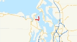
State Route 116 is a 9.38 miles (15.1 km) long state highway
located entirely in Jefferson County
, Washington, United States.
. The highway travels northwesterly through woodland, before crossing onto Indian Island
. The highway turns southeast, paralleling the coastline of the island, before looping northeasterly at the southern edge of the island. After turning north the highway parallels Scow Bay, entering Marrowstone
on Mystery Bay. Exiting the town, the highway moves towards the western edge of the island, entering more woodland before terminating at the access gate to Fort Flagler State Park
.
Every year the Washington State Department of Transportation
(WSDOT) conducts a series of surveys on its highways in the state to measure traffic volume. This is expressed in terms of average annual daily traffic (AADT), which is a measure of traffic volume for any average day of the year. In 2009, WSDOT calculated that as few as 460 cars traveled on the highway near the northern terminus, and as many as 6,700 cars used the highway at the southern terminus.
.
{| class="wikitable"
|-
!scope=col|Location
!scope=col|Mile
!scope=col|Destinations
!scope=col|Notes
|-
|
|0.00
|
|Western terminus
|-
|Fort Flagler State Park
|9.83
| Park gate
|Eastern terminus
|-
State highway
State highway, state road or state route can refer to one of three related concepts, two of them related to a state or provincial government in a country that is divided into states or provinces :#A...
located entirely in Jefferson County
Jefferson County, Washington
Jefferson County is a county located in the U.S. state of Washington, named after Thomas Jefferson. As of 2010, the population was 29,872. The county seat is at Port Townsend, which is also the county's only incorporated city....
, Washington, United States.
Route description
SR 116 begins at a t intersection with SR 19 north of ChimacumChimacum, Washington
Chimacum is an unincorporated community in eastern Jefferson County, Washington, United States. It lies on the Olympic Peninsula. It was named after the Chimakum group of Native Americans that lived there until the late 19th century.Chimacum is the home of Chimacum Schools' main campus, which...
. The highway travels northwesterly through woodland, before crossing onto Indian Island
Indian Island, Washington
Indian Island is an unincorporated community in Jefferson County, Washington, United States. It is located between Port Townsend Bay and Kilisut Harbor. Parts also border on Oak Bay and Scow Bay. Until the construction of the Port Townsend Ship Canal Indian Island was connected to the mainland...
. The highway turns southeast, paralleling the coastline of the island, before looping northeasterly at the southern edge of the island. After turning north the highway parallels Scow Bay, entering Marrowstone
Marrowstone, Washington
Marrowstone is a census-designated place in Jefferson County, Washington, USA. The population was 837 at the 2000 census. All Marrowstone addresses are in Nordland, Washington, and the ZIP code for Marrowstone Island is 98358....
on Mystery Bay. Exiting the town, the highway moves towards the western edge of the island, entering more woodland before terminating at the access gate to Fort Flagler State Park
Fort Flagler State Park
Fort Flagler State Park is a Washington state park on the site of Fort Flagler, a former United States Army fort at the northern end of Marrowstone Island. From Fort Flagler, visitors can see Port Townsend to the northwest, the cranes at the Navy base on Indian Island to the west, and Whidbey...
.
Every year the Washington State Department of Transportation
Washington State Department of Transportation
The Washington State Department of Transportation , was established in 1905. The agency, led by a Secretary and overseen by the Governor, is a Washington governmental agency that constructs, maintains, and regulates the use of the state's transportation infrastructure...
(WSDOT) conducts a series of surveys on its highways in the state to measure traffic volume. This is expressed in terms of average annual daily traffic (AADT), which is a measure of traffic volume for any average day of the year. In 2009, WSDOT calculated that as few as 460 cars traveled on the highway near the northern terminus, and as many as 6,700 cars used the highway at the southern terminus.
Major intersections
The entire route is located in Jefferson CountyJefferson County, Washington
Jefferson County is a county located in the U.S. state of Washington, named after Thomas Jefferson. As of 2010, the population was 29,872. The county seat is at Port Townsend, which is also the county's only incorporated city....
.
{| class="wikitable"
|-
!scope=col|Location
!scope=col|Mile
!scope=col|Destinations
!scope=col|Notes
|-
|
|0.00
|
|Western terminus
|-
|Fort Flagler State Park
Fort Flagler State Park
Fort Flagler State Park is a Washington state park on the site of Fort Flagler, a former United States Army fort at the northern end of Marrowstone Island. From Fort Flagler, visitors can see Port Townsend to the northwest, the cranes at the Navy base on Indian Island to the west, and Whidbey...
|9.83
|
|Eastern terminus
|-