
Warner County No. 5, Alberta
Encyclopedia
The County of Warner No. 5 is a municipal district in southern Alberta
Southern Alberta
Southern Alberta is a region located in the Canadian province of Alberta. As of the year 2004, the region's population was approximately 272,017. The primary cities are Lethbridge and Medicine Hat...
, Canada
Canada
Canada is a North American country consisting of ten provinces and three territories. Located in the northern part of the continent, it extends from the Atlantic Ocean in the east to the Pacific Ocean in the west, and northward into the Arctic Ocean...
.
It is located in Census Division 2
Division No. 2, Alberta
Division No. 2 is a census division in Alberta, Canada. It is located in the south-central portion of southern Alberta and includes the City of Lethbridge.- Census subdivisions :...
, just north of the United States
United States
The United States of America is a federal constitutional republic comprising fifty states and a federal district...
border. Warner was organised as a rural municipality
Rural municipality
A rural municipality, often abbreviated RM, is a form of municipality in the Canadian provinces of Manitoba and Saskatchewan, perhaps best comparable to counties or townships in the western United States...
since 1912, and established in the actual borders since 1954. The seat of the municipality is located in Warner
Warner, Alberta
Warner is a village in southern Alberta, Canada. It is located in County of Warner, approximately 65 km south of the city of Lethbridge. Warner is a farming community. Warner is situated at the intersection of Highway 4 and Highway 36, about 38 km north of the Montana border and...
.
Demographics
In 2006, the County of Warner No. 5 had a population of 3,674 living in 887 dwellingsHouse
A house is a building or structure that has the ability to be occupied for dwelling by human beings or other creatures. The term house includes many kinds of different dwellings ranging from rudimentary huts of nomadic tribes to free standing individual structures...
, a 3.3% decrease from 2001. However, this population has since been revised by Statistics Canada to 3,776. Using the pre-revised Statistics Canada data, the County of Warner No. 5 had a land area of 4519.77 km² (1,745.1 sq mi) and a population density
Population density
Population density is a measurement of population per unit area or unit volume. It is frequently applied to living organisms, and particularly to humans...
of 0.8 /km2.
In 2001, the County of Warner No. 5 had a population of 3,798 in 880 dwellings, a 6.7% increase from 1996. On a surface of 4,516.09 km² it had a density of 0.8 inhabitants/km².
Tourism and attractions
- Stirling Agricultural VillageStirling Agricultural VillageStirling Agricultural Village is a National Historic Site of Canada, and was listed as one of only three communities in Canada designated as a National Historic Site because of the community’s well preserved settlement pattern that follows the Plat of Zion model...
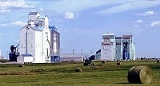
, National Historic Site of Canada - Warner elevator rowWarner elevator rowWarner elevator row is a row of historic wood-cribbed grain elevators with six elevators all standing in a row from south to north, alongside the Canadian Pacific Railway, that travels from Great Falls, Montana to Lethbridge, Alberta, on the east entrance of the village of Warner, Alberta, Canada...
, last surviving "Grain Elevator Row" in Alberta. - Galt Historic Railway ParkGalt Historic Railway ParkThe Galt Historic Railway Park, collects, preserves, restores, exhibits and interprets artifacts which represent the history and social impact of the "steam" era in southern Alberta and the coal era with emphasis on Galt Railway and the 1890 International Train Station Depot North West Territories...
- Michelsen FarmsteadMichelsen FarmsteadThe Andreas Michelsen Farmstead, originally built in 1902 by Andreas himself as a two room house. In 1912 the house was added onto, to make 7 rooms in total, little has changed since...
- William T. Ogden HouseWilliam T. Ogden HouseWilliam T. Ogden House is a historic Neo-Classical Georgian style brick mansion located on in Stirling, Alberta, Canada. Construction of the house began in 1910 and was finished in 1919 by William T. Ogden. The house has been a rooming house, pool hall and a dance studio, and in 1934 it became a...
- Lost Frontier Mini-Railway
- Writing-on-Stone Provincial ParkWriting-on-Stone Provincial ParkWriting-on-Stone Provincial Park is located about 100 kilometres southeast of Lethbridge, Alberta, Canada or 44 kilometres east of the community of Milk River, and straddles the Milk River itself. It is one of the largest areas of protected prairie in the Alberta park system, and serves as both a...
, - Devil's Coulee Dinosaur Heritage MuseumDevil's Coulee Dinosaur Heritage MuseumDevil's Coulee Dinosaur Heritage Museum, located in Warner, Alberta, Canada, is a key historic site in southern Alberta. In 1997, ten fossilized dinosaur eggs, believed to have come from a Hadrosaur, specifically a Hypacrosaurus were found at Devil's Coulee site...
- Centennial Park
- Stirling ElevatorStirling ElevatorStirling elevator is a large concrete grain terminal located three quarters of a mile north east of the town of Stirling, Alberta. The elevator stands 200 feet tall and is surrounded by grain fields that stretch out for hundreds of miles east, north and south.The large elevator was built between...
- Neils Hogenson HouseNeils Hogenson HouseThe Neils Hogenson home is an original catalogue order house purchased through the T. Eaton’s Co. Catalogue and built by Mr. Neils Hogensen. Shipped from Winnipeg by train, the home came to Stirling in crates with instruction, including shingles, lumber, doors, moldings, windows, paint, nails,...
- Andrew Larson HouseAndrew Larson HouseThe Andrew Larson House is a historic home located in Stirling. The house was built in 1906 by Andrew Larson, Sr. and has similarities to the Michelsen home. The house started as a two-room house, Larsen added on to the home in 1910 just before his mission to Denmark.-The Larson Family:Andrew...
- Temple HillTemple Hill (Warner County, Alberta)Temple Hill is an isolated hill located three kilometres north of Raymond, Alberta, Canada in Warner County.Temple Hill was so-named by Mormon settlers of Southern Alberta because some thought that it would be an appropriate site for a temple of The Church of Jesus Christ of Latter-day Saints...
- Raymond Golf Club
- Milk River Golf Club
Events
- Stirling Settler DaysStirling Settler DaysStirling Settler Days is a celebration held every year on July 24 in Stirling, Alberta, Canada.Stirling Settler Days is celebrated to mark the Mormon pioneers' arrival in the Salt Lake Valley on July 24, 1847...
- Victorian Prairie Christmas - Galt Railway Park
- Raymond StampedeRaymond StampedeThe Raymond Stampede is an annual rodeo that is held in the town of Raymond, Alberta, Canada every 1 July. It is notable for being Alberta's oldest and Canada's second oldest rodeo event, having been instituted a full decade before the world-famous Calgary Stampede.The Stampede was first held in...
History
The County of Warner No. 5 comprises approximately 50 townships, and is borderedon the south by the Canadian-United States border, It is composed of the former
Municipal District of Warner No. 36 and a portion of the former Municipal
District of Sugar City No. 37.
The following is the events that lead to the incorporation of the County of Warner No. 5:
- January, 1913 - Municipal District of Warner No. 36 incorporatedMunicipal corporationA municipal corporation is the legal term for a local governing body, including cities, counties, towns, townships, charter townships, villages, and boroughs. Municipal incorporation occurs when such municipalities become self-governing entities under the laws of the state or province in which...
.
- January 23, 1923 - Municipal District of Sugar City No. 37 incorporated.
- 1942 - Sugar City Municipality enlarged to include Local Improvement District
No. 7 and portions of Local Improvement Districts 8, 38 and 67.
- January 6, 1950 - Warner Municipality enlarged to include Milk RiverMilk River, AlbertaMilk River is a town in the province of Alberta, Canada, located on and named after the Milk River, which flows immediately to its south. It is south of Lethbridge, and from the Canada-U.S. border. It is primarily a service centre for the many farms and cattle ranches which surround...
, CouttsCoutts, AlbertaCoutts is a village in Alberta and the location of one of the busiest Canada – US border crossings in western Canada. It connects Highway 4 to Interstate 15, an important trade route between Alberta, American states along I-15, and Mexico.In 2004, a joint border facility opened in Coutts-Sweet...
and MasinasinMasinasin, AlbertaMasinasin is a former community in Alberta, Canada within the County of Warner No. 5. It is located off Highway 501 on Range Road 133, approximately east of the Town of Milk River and north of the United States-Canada border and Writing-on-Stone Provincial Park...
districts.
- December 31, 1953 - Sugar City dissolved and portion added to the Municipal District of Warner.
- January 1, 1954 - County of Warner No. 5 incorporated.
Communities
The following communities are located in this municipal district:Towns
- Milk RiverMilk River, AlbertaMilk River is a town in the province of Alberta, Canada, located on and named after the Milk River, which flows immediately to its south. It is south of Lethbridge, and from the Canada-U.S. border. It is primarily a service centre for the many farms and cattle ranches which surround...
- RaymondRaymond, AlbertaRaymond is a town in Warner County, Alberta, Canada. It is located in southern Alberta south of Lethbridge on Highway 52. Raymond is known for its annual rodeo and its large Mormon population...
Villages
- CouttsCoutts, AlbertaCoutts is a village in Alberta and the location of one of the busiest Canada – US border crossings in western Canada. It connects Highway 4 to Interstate 15, an important trade route between Alberta, American states along I-15, and Mexico.In 2004, a joint border facility opened in Coutts-Sweet...
- StirlingStirling, AlbertaStirling is a village in the County of Warner No. 5, Alberta, Canada. The village is located on Highway 4, approximately southeast of Lethbridge and northwest of the United States-Canada border....
- WarnerWarner, AlbertaWarner is a village in southern Alberta, Canada. It is located in County of Warner, approximately 65 km south of the city of Lethbridge. Warner is a farming community. Warner is situated at the intersection of Highway 4 and Highway 36, about 38 km north of the Montana border and...
Hamlets
- New DaytonNew Dayton, AlbertaNew Dayton is a hamlet in southern Alberta, Canada within the County of Warner No. 5. It is located on Highway 4 between the villages of Stirling and Warner, approximately southeast of Lethbridge.- Services and amenities :...
- WrenthamWrentham, AlbertaWrentham is a hamlet in southern Alberta, Canada within the County of Warner No. 5. It is located southeast of the intersection of the Veteran Memorial Highway and the historic Red Coat Trail , approximately east of the Village of Stirling, south of the Town of Taber and west of the Village of...
Other unincorporated communities
- AllerstonAllerston, AlbertaAllerston, formerly Allersville, is an unincorporated community in Alberta, Canada within the County of Warner No. 5. It is located approximately east of the Town of Milk River and north of the United States-Canada border on Township Road 24, off Highway 501. All that remains of Allerston is a...
(Doran) - Conrad
- ClarindaClarinda, AlbertaClarinda is a former unincorporated community in southern Alberta, Canada within the County of Warner No. 5. It is located south of Highway 501, southeast of the Town of Milk River, and east of the Village of Coutts. It is approximately southeast of the City of Lethbridge.-Education:Clarinda...
- CraddockCraddock, AlbertaCraddock is a former unincorporated community in southern Alberta, Canada within the County of Warner No. 5. It is located between the villages of Stirling and Hamlet of New Dayton, approximately southeast of the City of Lethbridge on Highway 4.- History :...
- JudsonJudson, AlbertaJudson is a former unincorporated community in southern Alberta, Canada within the County of Warner No. 5. It is located on Highway 61 between the villages of Stirling and Wrentham, approximately southeast of the City of Lethbridge.- Regional attractions :...
- Knappen
- Lucky Strike
- MasinasinMasinasin, AlbertaMasinasin is a former community in Alberta, Canada within the County of Warner No. 5. It is located off Highway 501 on Range Road 133, approximately east of the Town of Milk River and north of the United States-Canada border and Writing-on-Stone Provincial Park...
- MaybuttMaybutt, AlbertaMaybutt also known as “New Stirling” or "New Town" is a former locality in Warner County, Alberta, Canada. The unincorporated community is situated 1 km north of the old town of Stirling just off the CANAMEX Corridor between Lethbridge and the United States-Canada border...
- McNabMcNab, AlbertaMcNab is a former unincorporated community in southern Alberta, Canada within the County of Warner No. 5. It is located on Highway 506 between the Hamlet of New Dayton and the Village of Warner, approximately southeast of the City of Lethbridge....
- One-SeventeenOne-Seventeen, AlbertaOne-Seventeen is a former unincorporated community in southern Alberta, Canada within the County of Warner No. 5. It is located south of Highway 501, south of the Town of Milk River, and west of the Village of Coutts. It is approximately southeast of the City of Lethbridge.-Education:Bankview...
- St. KildaSt. Kilda, AlbertaSt. Kilda is a former unincorporated community in southern Alberta, Canada within the County of Warner No. 5. It is located south of Highway 500 on township road 12-1A, southeast of the Town of Milk River, and east of the Village of Coutts. It is approximately southeast of the City of...
- Two-Fifteen
Education
Westwind School Division No. 74Westwind School Division No. 74
Westwind School Division No. 74 is a public school board serving the counties of Warner and Cardston.-Schools:Cardston* Cardston Elementary School * Cardston Jr. High School * Cardston High School Glenwood* Glenwood School...
and Horizon School Division No. 67 provide education within the boundaries of the County of Warner No. 5.
Early school districts
Listed below are the former school districts that once provided education within the County of Warner No. 5.| Name & SD No. | Image | Location Alberta Township System The Alberta Township System is a land surveying system used in the Canadian province of Alberta and other parts of western Canada.-History and background:... | Date Established | Date Closed/ Disbanded | Notes |
|---|---|---|---|---|---|
| Galt/Stirling No. 647 |  |
29 - 6 - 19 - W4 | 19 November 1901 | Originally named Galt, the name was changed to Stirling in 1957. | |
| Raymond No. 700 | 8 - 6 - 20 - W4 | 1 May 1902 | |||
| Mammoth No. 1379 | 24 - 5 - 20 - W4 | 9 August 1905 | |||
| Warner No. 1675 | 10 - 4 - 17 - W4 | 31 July 1907 | |||
| Tyrells Lake No. 2007 | 20-5-17-W4 | 8 July 1909 | 1939 | Demolished 1940s | |
| Milk River Valley/Masinasin No. 2024 | 15 - 2 - 13 - W4 | 24 August 1909 | Originally named Milk River Valley, the name was changed to Masinasin in 1941. | ||
| Milk River No. 2056 | 15 - 2 - 13 - W4 | 8 October 1909 | |||
| Grain No. 2597 | 15-1-11-W4 | 25 November 1911 | |||
| West Butte/St. Kilda No. 2747 | 11-1-12-W4 | 25 May 1912 | Originally named West Butte, the name was changed to St. Kilda in 1920. | ||
| Indian Rock No. 2540 | 18-1-12 -W4 moved? to 11 - 1 - 12 - W4 | 25 August 1911 | |||
| Locke No. 2730 | 31-1-13 -W4 Moved? to 28 - 2 - 13 - W4 | 10 May 1912 | |||
| Clarinda No. 2459 | 8-1-13 -W4 | 10 June 1911 | |||
| Verburg No. 2439 | 33-1-14 -W4 | 10 May 1911 | |||
| Sexton Creek No. 2510 | 9-1-14 -W4 moved? to 33 - 1 - 14 - W4 | 24 July 1911 | |||
| Lind No. 2170 | 34-1-16 -W4 | 25 April 1910 | |||
| John Joes No. 2198 | 24-1-17-W4 | 26 May 1910 | Also spelled John Jo | ||
| Two Fifteen No. 2153 | 20-2-15-W4 | 26 March 1910 March 26 | Moved to Milk River for a class room when the district was joined with Milk River Consolidated District 12, December 1945 | ||
| Sleepy Hollow No. 2634 | 24-2-15-W4 | 25 January 1912 | |||
| Lucky Strike No. 2589 | 17-3-11-W4 | 9 November 1911 | |||
| Prairie Round No. 2152 | 21-3-12-W4 | 26 March 1910 March 26 | |||
| Patience No. 2156 | 23-6-17-W4 | 26 March 1910 | |||
| Maybutt | 32-6-19-W4 | 1912 | |||
| Kippen No. 2080 | 34-2-12-W4 | 9 December 1909 | 1933 | Kippenville Consolidated 7 created in 1915 by Kippen & Green Villa disorganized in 1933 | |
| Bankview No. 3042 | 16-1-17-W4 | 1913 | 1953 | ||
| Craddock/Bluesky No. 3456 | 33 - 81 - 2 - W6 | 15 February 1917 | Originally named Craddock, the name was changed to Bluesky in 1947. | ||
| Coutts No. 3560 | 4 - 1 - 15 - W4 | 30 October 1917 | |||
| North Wrentham No. 3618 | 7 - 16 - W4 | 18 February 1918 | |||
| Wrentham No. 3617 | 36 - 6 - 17 - W4 | 18 February 1918 | |||
| Conrad No. 4077 | 11 - 61 - 12 - W4 | 3 November 1921 |