

Vratsa Peak
Encyclopedia
Breznik Heights
Breznik Heights rises to over 600 m in the southeast part of Greenwich Island. They extend 12 km between Santa Cruz Point in the north east and the base of the moraine spit at the mouth of Yankee Harbour in the southwest...
, Greenwich Island
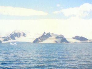
Greenwich Island (South Shetland Islands)
Greenwich Island is an island long and from wide, lying between Robert Island and Livingston Island in the South Shetland Islands. Surface area...
in the South Shetland Islands
South Shetland Islands
The South Shetland Islands are a group of Antarctic islands, lying about north of the Antarctic Peninsula, with a total area of . By the Antarctic Treaty of 1959, the Islands' sovereignty is neither recognized nor disputed by the signatories and they are free for use by any signatory for...
, Antarctica surmounting Musala Glacier
Musala Glacier
Musala Glacier on Greenwich Island in the South Shetland Islands, Antarctica is bounded by St. Kiprian Peak to the south, Vratsa Peak to the southwest, central Breznik Heights to the west, and Ilarion Ridge bordering Hardy Cove to the northeast...
to the northeast and Targovishte Glacier
Targovishte Glacier
Targovishte Glacier is situated in Breznik Heights on Greenwich Island, and is bounded by Viskyar Ridge to the west, Vratsa Peak to the northeast, and Drangov Peak and Ziezi Peak to the east...
to the southwest and south.
The feature is named after the city of Vratsa
Vratsa
Vratsa is a city in northwestern Bulgaria, at the foothills of the Balkan Mountains. It is the administrative centre of the homonymous Vratsa Province. As of February 2011, the town has a population of 60,482 inhabitants....
in northwestern Bulgaria
Bulgaria
Bulgaria , officially the Republic of Bulgaria , is a parliamentary democracy within a unitary constitutional republic in Southeast Europe. The country borders Romania to the north, Serbia and Macedonia to the west, Greece and Turkey to the south, as well as the Black Sea to the east...
.
Location
The peak is located at 62°32′26"S 59°38′09"W which is 1.14 km east of the summit of Viskyar RidgeViskyar Ridge
Viskyar Ridge is a rocky ridge rising to 600 m and extending 2.5 km in north-south direction in Breznik Heights, Greenwich Island in the South Shetland Islands, Antarctica. The ice-free surface area of the ridge is...
, 1.1 km south of Lyutitsa Nunatak
Lyutitsa Nunatak
Lyutitsa Nunatak is a rocky peak of elevation 430 m projecting from the ice cap in Breznik Heights on Greenwich Island, Antarctica. Overlooking Musala Glacier to the north, east, and south...
, 1.54 km west of St. Kiprian Peak
St. Kiprian Peak
St. Kiprian Peak is a rocky peak of elevation 270 m in the southeast extremity of Breznik Heights on Greenwich Island, Antarctica. Situated 1.54 km east of Vratsa Peak, 1.7 km south of Ilarion Ridge, 1.63 km west of Fort Point, and 800 m northeast of Kormesiy Peak. Overlooking...
, 3.13 km west of Fort Point
Fort Point
Fort Point is located at the southern side of the Golden Gate at the entrance to San Francisco Bay. This fort was completed just before the American Civil War, to defend San Francisco Bay against hostile warships...
and 2.38 km northeast of Sartorius Point
Sartorius Point
Sartorius Point is a sharp ice-free tipped point formed by an offshoot of Viskyar Ridge and marking the south extremity of Greenwich Island in the South Shetland Islands, Antarctica. The point separates the termini of Zheravna Glacier to the west and Targovishte Glacier to the east...
(Bulgarian topographic survey Tangra 2004/05
Tangra 2004/05
The Tangra 2004/05 Expedition was commissioned by the Antarctic Place-names Commission at the Ministry of Foreign Affairs of Bulgaria, managed by the Manfred Wörner Foundation, and supported by the Bulgarian Antarctic Institute, the Institute of Mathematics and Informatics at the Bulgarian Academy...
and mapping in 2009).
Maps
- L.L. Ivanov et al. Antarctica: Livingston Island and Greenwich Island, South Shetland Islands. Scale 1:100000 topographic map. Sofia: Antarctic Place-names Commission of Bulgaria, 2005.
- L.L. Ivanov. Antarctica: Livingston Island and Greenwich, Robert, Snow and Smith Islands. Scale 1:120000 topographic map. Troyan: Manfred Wörner Foundation, 2009. ISBN 978-954-92032-6-4