

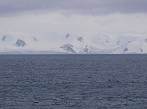
Musala Glacier
Encyclopedia
Greenwich Island (South Shetland Islands)
Greenwich Island is an island long and from wide, lying between Robert Island and Livingston Island in the South Shetland Islands. Surface area...
in the South Shetland Islands
South Shetland Islands
The South Shetland Islands are a group of Antarctic islands, lying about north of the Antarctic Peninsula, with a total area of . By the Antarctic Treaty of 1959, the Islands' sovereignty is neither recognized nor disputed by the signatories and they are free for use by any signatory for...
, Antarctica is bounded by St. Kiprian Peak
St. Kiprian Peak
St. Kiprian Peak is a rocky peak of elevation 270 m in the southeast extremity of Breznik Heights on Greenwich Island, Antarctica. Situated 1.54 km east of Vratsa Peak, 1.7 km south of Ilarion Ridge, 1.63 km west of Fort Point, and 800 m northeast of Kormesiy Peak. Overlooking...
to the south, Vratsa Peak
Vratsa Peak
Vratsa Peak is a sharp rocky peak rising to 470 m in Breznik Heights, Greenwich Island in the South Shetland Islands, Antarctica surmounting Musala Glacier to the northeast and Targovishte Glacier to the southwest and south....
to the southwest, central Breznik Heights
Breznik Heights
Breznik Heights rises to over 600 m in the southeast part of Greenwich Island. They extend 12 km between Santa Cruz Point in the north east and the base of the moraine spit at the mouth of Yankee Harbour in the southwest...
to the west, and Ilarion Ridge
Ilarion Ridge
Ilarion Ridge is a partly ice-free ridge of elevation 240 m situated in Breznik Heights on Greenwich Island, Antarctica. Extending along the south coast of Hardy Cove, 2 km southwest of Parchevich Ridge, 1.9 km east-northeast of Lyutitsa Nunatak, 2.5 km northeast of Vratsa Peak,...
bordering Hardy Cove
Hardy Cove
Hardy Cove is the 950 m wide cove indenting for 1.37 km the east coast of Greenwich Island in the South Shetland Islands, Antarctica and surmounted by Parchevich Ridge to the north and Ilarion Ridge to the south...
to the northeast. It extends 3.7 km in east-west direction and 2.2 km in north-south direction, and drains eastwards into Bransfield Strait
Bransfield Strait
Bransfield Strait is a body of water about wide extending for in a general northeast-southwest direction between the South Shetland Islands and Antarctic Peninsula. It was named in about 1825 by James Weddell, Master, Royal Navy, for Edward Bransfield, Master, RN, who charted the South Shetland...
north of Fort Point
Fort Point
Fort Point is located at the southern side of the Golden Gate at the entrance to San Francisco Bay. This fort was completed just before the American Civil War, to defend San Francisco Bay against hostile warships...
.
The glacier is named after Musala Peak
Musala
Musala is the highest peak in Bulgaria and the entire Balkan Peninsula, standing at 2,925 m . The summit of the Rila mountain in southwestern Bulgaria, Musala is the highest peak between the Alps and the Caucasus and the highest in Eastern Europe bar the Caucasus.Between 1949–1962 the peak was...
in the Rila Mountain
Rila
Rila is a mountain range in southwestern Bulgaria and the highest mountain range of Bulgaria and the Balkans, with its highest peak being Musala at 2,925 m...
, the summit of Bulgaria
Bulgaria
Bulgaria , officially the Republic of Bulgaria , is a parliamentary democracy within a unitary constitutional republic in Southeast Europe. The country borders Romania to the north, Serbia and Macedonia to the west, Greece and Turkey to the south, as well as the Black Sea to the east...
and the Balkan Peninsula.
Maps
- L.L. Ivanov et al. Antarctica: Livingston Island and Greenwich Island, South Shetland Islands. Scale 1:100000 topographic map. Sofia: Antarctic Place-names Commission of Bulgaria, 2005.
- L.L. Ivanov. Antarctica: Livingston Island and Greenwich, Robert, Snow and Smith Islands. Scale 1:120000 topographic map. Troyan: Manfred Wörner Foundation, 2009. ISBN 978-954-92032-6-4