

Viola, New York
Encyclopedia
Viola is a hamlet in the Town of Ramapo
Rockland County
, New York
, United States
located north of Airmont
; east of Montebello
; south of Wesley Hills
and west of Hillcrest. The population was 5,931 at the 2000 census.
. Rockland County had purchased the 47 acres (190,202.4 m²) parsonage farm of the Kakiat (West New Hempstead
) Dutch Reformed Church (also known as the Brick Church) for use as an Alms House. There the county originally built a wooden frame house to serve the poor. The inmates contributed to their upkeep by tending the farm. In 1883, a brick building was constructed. The facility included a school for the children. In 1957, the Alms House was moved to Building “C” at the Pomona Health Center in Summit Park, and the property would become the site of Rockland Community College
. The Alms House was re-named the Rockland County Infirmary and Home. In 1977, it was removed to Building “A”. It has been re-named the Summit Park Nursing Care Center.
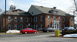 The old brick Alms House building remains as an Administration Building (Daniel T Brucker Hall), used by Rockland Community College. The farm lands are the campus. The Poor Cemetery (Potter’s Field) remains on the RCC campus, along with the original Gary Onderdonk Veteran’s Cemetery.
According to the United States Census Bureau
, the CDP has a total area of 2.7 square miles (7 km²), all land.
of 2000, there were 5,931 people, 1,681 households, and 1,250 families residing in the CDP. The population density
was 2,192.4 per square mile (845.0/km²). There were 1,738 housing units at an average density of 642.4/sq mi (247.6/km²). The racial makeup of the CDP was 97.81% White, 0.32% African American, 0.05% Native American, 0.67% Asian, 0.07% Pacific Islander, 0.46% from other races
, and 0.62% from two or more races. Hispanic or Latino of any race were 2.61% of the population.
There were 1,681 households out of which 40.7% had children under the age of 18 living with them, 68.7% were married couples
living together, 4.1% had a female householder with no husband present, and 25.6% were non-families. 24.4% of all households were made up of individuals and 20.6% had someone living alone who was 65 years of age or older. The average household size was 3.53 and the average family size was 4.34.
In the CDP the population was spread out with 39.9% under the age of 18, 8.3% from 18 to 24, 17.6% from 25 to 44, 18.9% from 45 to 64, and 15.3% who were 65 years of age or older. The median age was 28 years. For every 100 females there were 92.4 males. For every 100 females age 18 and over, there were 87.2 males.
The median income for a household in the CDP was $59,821, and the median income for a family was $87,273. Males had a median income of $68,533 versus $39,375 for females. The per capita income
for the CDP was $27,289. About 4.9% of families and 6.5% of the population were below the poverty line, including 6.3% of those under age 18 and 9.6% of those age 65 or over.
Ramapo, New York
Ramapo , formerly known as New Hempstead and then Hampstead, is a town in Rockland County, New York, United States located north of New Jersey; southeast of Orange County, New York; south of the Town of Haverstraw and west of the Town of Clarkstown and the Town of Orangetown...
Rockland County
Rockland County, New York
Rockland County is a suburban county 15 miles to the northwest of Manhattan and part of the New York City Metropolitan Area, in the U.S. state of New York. It is the southernmost county in New York west of the Hudson River, and the smallest county in New York outside of New York City. The...
, New York
New York
New York is a state in the Northeastern region of the United States. It is the nation's third most populous state. New York is bordered by New Jersey and Pennsylvania to the south, and by Connecticut, Massachusetts and Vermont to the east...
, United States
United States
The United States of America is a federal constitutional republic comprising fifty states and a federal district...
located north of Airmont
Airmont, New York
Airmont is a village in the town of Ramapo, Rockland County, New York, United States located north of the state of New Jersey; east of Suffern; south of Montebello and west of Chestnut Ridge. The population was 7,799 at the 2000 census....
; east of Montebello
Montebello, New York
Montebello is a village in the town of Ramapo Rockland County, New York, United States. It is located north of Suffern, east of Hillburn, south of Wesley Hills and west of Airmont...
; south of Wesley Hills
Wesley Hills, New York
Wesley Hills is a village in the Town of Ramapo, Rockland County, New York, United States located north of Viola; east of Harriman State Park; south of Pomona and west of New Hempstead...
and west of Hillcrest. The population was 5,931 at the 2000 census.
Alms House
The Alms House (or County Poor House) was established in 1837, at Viola, (then known as Mechanicsville) in the Town of Ramapo, for the poor and destitute (debtors). It was 7 miles (11.3 km) West of New CityNew City, New York
New City is a hamlet , in the Town of Clarkstown Rockland County, New York, United States, part of the New York Metropolitan Area. The hamlet is a suburb of New York City, located 18 miles north of the city at the closest point, Riverdale, The Bronx...
. Rockland County had purchased the 47 acres (190,202.4 m²) parsonage farm of the Kakiat (West New Hempstead
New Hempstead, New York
New Hempstead, formally known as Kakiat , is a village in the Town of Ramapo, Rockland County, New York, United States located north of New Square; east of Wesley Hills; south of Pomona and west of New City...
) Dutch Reformed Church (also known as the Brick Church) for use as an Alms House. There the county originally built a wooden frame house to serve the poor. The inmates contributed to their upkeep by tending the farm. In 1883, a brick building was constructed. The facility included a school for the children. In 1957, the Alms House was moved to Building “C” at the Pomona Health Center in Summit Park, and the property would become the site of Rockland Community College
Rockland Community College
Rockland Community College is a two-year college in the State University of New York system, located in hamlet of Viola within the Village of Suffern from the Town of Ramapo in Rockland County, New York. The college began in 1959 in the former county almshouse. The college offers 48 programs and...
. The Alms House was re-named the Rockland County Infirmary and Home. In 1977, it was removed to Building “A”. It has been re-named the Summit Park Nursing Care Center.
Geography
Viola is located at 41°7′35"N 74°5′0"W (41.126295, -74.083285).According to the United States Census Bureau
United States Census Bureau
The United States Census Bureau is the government agency that is responsible for the United States Census. It also gathers other national demographic and economic data...
, the CDP has a total area of 2.7 square miles (7 km²), all land.
Demographics
As of the censusCensus
A census is the procedure of systematically acquiring and recording information about the members of a given population. It is a regularly occurring and official count of a particular population. The term is used mostly in connection with national population and housing censuses; other common...
of 2000, there were 5,931 people, 1,681 households, and 1,250 families residing in the CDP. The population density
Population density
Population density is a measurement of population per unit area or unit volume. It is frequently applied to living organisms, and particularly to humans...
was 2,192.4 per square mile (845.0/km²). There were 1,738 housing units at an average density of 642.4/sq mi (247.6/km²). The racial makeup of the CDP was 97.81% White, 0.32% African American, 0.05% Native American, 0.67% Asian, 0.07% Pacific Islander, 0.46% from other races
Race (United States Census)
Race and ethnicity in the United States Census, as defined by the Federal Office of Management and Budget and the United States Census Bureau, are self-identification data items in which residents choose the race or races with which they most closely identify, and indicate whether or not they are...
, and 0.62% from two or more races. Hispanic or Latino of any race were 2.61% of the population.
There were 1,681 households out of which 40.7% had children under the age of 18 living with them, 68.7% were married couples
Marriage
Marriage is a social union or legal contract between people that creates kinship. It is an institution in which interpersonal relationships, usually intimate and sexual, are acknowledged in a variety of ways, depending on the culture or subculture in which it is found...
living together, 4.1% had a female householder with no husband present, and 25.6% were non-families. 24.4% of all households were made up of individuals and 20.6% had someone living alone who was 65 years of age or older. The average household size was 3.53 and the average family size was 4.34.
In the CDP the population was spread out with 39.9% under the age of 18, 8.3% from 18 to 24, 17.6% from 25 to 44, 18.9% from 45 to 64, and 15.3% who were 65 years of age or older. The median age was 28 years. For every 100 females there were 92.4 males. For every 100 females age 18 and over, there were 87.2 males.
The median income for a household in the CDP was $59,821, and the median income for a family was $87,273. Males had a median income of $68,533 versus $39,375 for females. The per capita income
Per capita income
Per capita income or income per person is a measure of mean income within an economic aggregate, such as a country or city. It is calculated by taking a measure of all sources of income in the aggregate and dividing it by the total population...
for the CDP was $27,289. About 4.9% of families and 6.5% of the population were below the poverty line, including 6.3% of those under age 18 and 9.6% of those age 65 or over.