

Via Blanca (Cuba)
Encyclopedia

Cuba
The Republic of Cuba is an island nation in the Caribbean. The nation of Cuba consists of the main island of Cuba, the Isla de la Juventud, and several archipelagos. Havana is the largest city in Cuba and the country's capital. Santiago de Cuba is the second largest city...
, connecting the capital city of Havana
Havana
Havana is the capital city, province, major port, and leading commercial centre of Cuba. The city proper has a population of 2.1 million inhabitants, and it spans a total of — making it the largest city in the Caribbean region, and the most populous...
and the city of Matanzas
Matanzas
Matanzas is the capital of the Cuban province of Matanzas. It is famed for its poets, culture, and Afro-Cuban folklore.It is located on the northern shore of the island of Cuba, on the Bay of Matanzas , east of the capital Havana and west of the resort town of Varadero.Matanzas is called the...
. A second section extends eastwards from Matanzas to the tourist town of Varadero.
It is mostly a four lane highway
Highway
A highway is any public road. In American English, the term is common and almost always designates major roads. In British English, the term designates any road open to the public. Any interconnected set of highways can be variously referred to as a "highway system", a "highway network", or a...
, with some divided sections. It runs east-west for 85 km between Havana and Matanzas, crossing the town of Santa Cruz del Norte
Santa Cruz del Norte
Santa Cruz del Norte is a municipality in the Mayabeque Province of Cuba. Before 2011 belonged to [La Habana Province]. It is located in the north shore, between the cities of Havana and Matanzas, at the mouth of the Santa Cruz River....
, and an additional 53 km east to Varadero, at the northern tip of Peninsula de Hicacos (the section between Matanzas and Varadero is a toll road
Toll road
A toll road is a privately or publicly built road for which a driver pays a toll for use. Structures for which tolls are charged include toll bridges and toll tunnels. Non-toll roads are financed using other sources of revenue, most typically fuel tax or general tax funds...
). Most of the highway runs along the Straits of Florida
Straits of Florida
The Straits of Florida, Florida Straits, or Florida Strait is a strait located south-southeast of the North American mainland, generally accepted to be between the Gulf of Mexico and the Atlantic Ocean, and between the Florida Keys and Cuba. The strait carries the Florida Current, the beginning of...
shoreline.
This is one of the busiest highways in Cuba, as it joins the two tourist destinations of Havana and Varadero.
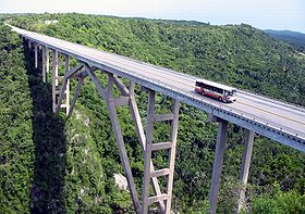
Construction of the highway begun in 1945; the bridge of Bacunayagua, on the La Habana/Matanzas
Matanzas Province
Matanzas is one of the provinces of Cuba. Major towns in the province include Cárdenas, Colón, Jovellanos and the capital of the same name, Matanzas...
province border, was completed in 1960. This is the highest bridge in Cuba.
Route description

From west to east, the Via Blanca then passes:
- the beach resort of Tarara
- the beach of Santa Maria del MarSanta Maria del MarThis article is about the beach in Havana, Cuba. For other uses, see Santa María del Mar Santa María del Mar is a sandy beach located 12 miles east of Havana, Cuba along the Via Blanca highway....
- the resort town of Guanabo
- the oil fields of Boca de Jaruco
- the city of Santa Cruz del NorteSanta Cruz del NorteSanta Cruz del Norte is a municipality in the Mayabeque Province of Cuba. Before 2011 belonged to [La Habana Province]. It is located in the north shore, between the cities of Havana and Matanzas, at the mouth of the Santa Cruz River....
- the beach and resort of Jibacoa
- the Mirador de BacunayaguaBacunayagua, CubaBacunayagua is a placename in northern Cuba. It marks the boundary between the Havana Province and Matanzas Province.The small settlement was established on the side of the Via Blanca , where a deep canyon cuts the coastal hills between the Yumuri Valley and the Straits of Florida coast...
, overlooking the highest bridge in Cuba - the city of Matanzas
- the Caves of Bellamar near Matanzas
- the Canimar River (boatingBoatingBoating is the leisurely activity of travelling by boat, or the recreational use of a boat whether powerboats, sailboats, or man-powered vessels , focused on the travel itself, as well as sports activities, such as fishing or water skiing...
) - the Juan Gualberto Gómez AirportJuan Gualberto Gomez AirportJuan Gualberto Gómez Airport is an international airport serving Varadero, Cuba and the province of Matanzas. The airport is located closer to the town of Matanzas than to Varadero. The closest airport to Varadero is Santa Marta Airport...
- the resort town of VaraderoVaraderoVaradero is a resort town in the province of Matanzas, Cuba, and one of the largest resort areas in the Caribbean. Varadero is also called Playa Azul, which means "blue beach" in Spanish.-Geography:...
(white sand beaches and all-inclusive resorts)
External links
- Via Blanca webpage (with photos)