

Via Balbia
Encyclopedia
Libya
Libya is an African country in the Maghreb region of North Africa bordered by the Mediterranean Sea to the north, Egypt to the east, Sudan to the southeast, Chad and Niger to the south, and Algeria and Tunisia to the west....
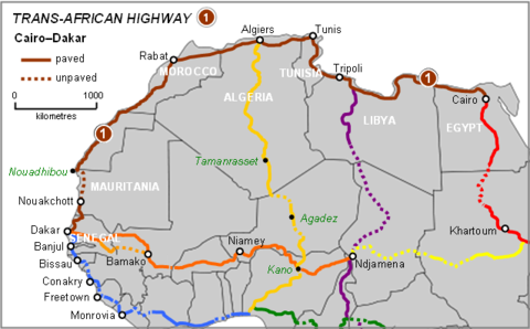
n Mediterranean coastline. It is a section in the Cairo–Dakar Highway #1 in the Trans-African Highway system of the African Union
African Union
The African Union is a union consisting of 54 African states. The only all-African state not in the AU is Morocco. Established on 9 July 2002, the AU was formed as a successor to the Organisation of African Unity...
, Arab Maghreb Union
Arab Maghreb Union
The Arab Maghreb Union is a trade agreement aiming for economic and some sort of future political unity in North Africa between the countries Morocco, Algeria, Tunisia, Libya, and Mauritania...
and others.
Built under the rule of the Italian dictator Benito Mussolini
Benito Mussolini
Benito Amilcare Andrea Mussolini was an Italian politician who led the National Fascist Party and is credited with being one of the key figures in the creation of Fascism....
in colonial Italian Libya
Italian Libya
Italian Libya was a unified colony of Italian North Africa established in 1934 in what represents present-day Libya...
in the 1930s, it was named Via Balbia (or Via Balbo) in honour of governor-general Italo Balbo
Italo Balbo
Italo Balbo was an Italian Blackshirt leader who served as Italy's Marshal of the Air Force , Governor-General of Libya, Commander-in-Chief of Italian North Africa , and the "heir apparent" to Italian dictator Benito Mussolini.After serving in...
, but renamed to Libyan Coastal Highway after independence. In the 2011 Libyan civil war
2011 Libyan civil war
The 2011 Libyan civil war was an armed conflict in the North African state of Libya, fought between forces loyal to Colonel Muammar Gaddafi and those seeking to oust his government. The war was preceded by protests in Benghazi beginning on 15 February 2011, which led to clashes with security...
the highway was a strategic and symbolic element, as the main route through the contested coastal region between Sirte
Sirte
Sirte is a city in LibyaSirte may also refer to:* Sirte Declaration, a 1999 resolution to create the African Union* Sirte Oil Company, a Libyan oil companyIn geography:* Gulf of Sirte, alias for Gulf of Sidra on Libya's coast...
and Benghazi
Benghazi
Benghazi is the second largest city in Libya, the main city of the Cyrenaica region , and the former provisional capital of the National Transitional Council. The wider metropolitan area is also a district of Libya...
.
History
Italian Libya
In March 1937, Italian dictator Benito Mussolini made a state visit to Italian Libya to open this new military and civilian highway, built by governor-general Italo Balbo. When Balbo died in 1940 in a plane crash, the Italian government named the 1822 kilometer road in his honour.Italians constructed also a minor road parallel to the coastal one starting from Marj through Marawa, to Lamluda
Lamluda
Lamluda is a village in the Jebel Akhdar region of Libya. It's located east of Bayda.Lamluda is on the cross-roads of several roads in northern Cyrenaica:...
, and it's 143 km (89 mi) long.
Near the middle of the road, the border of Italian Tripolitania
Italian Tripolitania
Italian Tripolitania was an African colony, in present day western Libya, of the Kingdom of Italy from 1927 to 1934. It was part of the Italian North Africa territory conquered from the Ottoman empire in 1911...
and Italian Cyrenaica
Italian Cyrenaica
Italian Cyrenaica was an African colony, in present day eastern Libya, of the Kingdom of Italy from 1927 to 1934. It was part of the Italian North Africa territory conquered from the Ottoman empire in 1911.-History:...
was marked by a Marble Arch
Marble Arch (Libya)
The Marble Arch , formerly known in Libya as El Gaus , was a monument in Libya built during the days of Italian colonization...
, named Arch of Fileni. It was created by the Italian architect Florestano Di Fausto. There was an inscription at the top of the arch which read: Alme Sol, possis nihil urbe Roma visere maius (Latin for "Oh kind Sun, may you never look upon a city greater than Rome"). The "Arch of Fileni" was demolished in 1970 by the new coup d'état revolutionary regime of Muammar al-Gaddafi
Muammar al-Gaddafi
Muammar Muhammad Abu Minyar Gaddafi or "September 1942" 20 October 2011), commonly known as Muammar Gaddafi or Colonel Gaddafi, was the official ruler of the Libyan Arab Republic from 1969 to 1977 and then the "Brother Leader" of the Libyan Arab Jamahiriya from 1977 to 2011.He seized power in a...
.
World War II
The highway was fully paved. However in World War IIWorld War II
World War II, or the Second World War , was a global conflict lasting from 1939 to 1945, involving most of the world's nations—including all of the great powers—eventually forming two opposing military alliances: the Allies and the Axis...
, during the Western Desert Campaign
Western Desert Campaign
The Western Desert Campaign, also known as the Desert War, was the initial stage of the North African Campaign during the Second World War. The campaign was heavily influenced by the availability of supplies and transport. The ability of the Allied forces, operating from besieged Malta, to...
of the Allies North African Campaign
North African campaign
During the Second World War, the North African Campaign took place in North Africa from 10 June 1940 to 13 May 1943. It included campaigns fought in the Libyan and Egyptian deserts and in Morocco and Algeria and Tunisia .The campaign was fought between the Allies and Axis powers, many of whom had...
, the road was heavily used in fighting the Axis command, and remained partially damaged for decades.
Independent Libya
The road was renamed Libyan Coastal Highway after the country gained independence. It was repaved in 1967. According to Hussein MaziqHussein Maziq
Hussein Yousef Maziq a Libyan politician was Prime Minister of Libya from 20 March 1965 to 2 July 1967. He was one of the most important men in the Kingdom era of Libya.-Family background:...
, prime minister of Libya
Libya
Libya is an African country in the Maghreb region of North Africa bordered by the Mediterranean Sea to the north, Egypt to the east, Sudan to the southeast, Chad and Niger to the south, and Algeria and Tunisia to the west....
(1965–1967) under King Idris, there had been plans to make this road a dual carriageway road. Two parts were built: the Sabratha
Sabratha
Sabratha, Sabratah or Siburata , in the Zawiya District in the northwestern corner of modern Libya, was the westernmost of the "three cities" of Tripolis. From 2001 to 2007 it was the capital of the former Sabratha wa Sorman District. It lies on the Mediterranean coast about west of Tripoli...
—Tripoli
Tripoli
Tripoli is the capital and largest city in Libya. It is also known as Western Tripoli , to distinguish it from Tripoli, Lebanon. It is affectionately called The Mermaid of the Mediterranean , describing its turquoise waters and its whitewashed buildings. Tripoli is a Greek name that means "Three...
—Misrata section; and the Ajdabiya
Ajdabiya
Ajdabiya was one of the districts of Libya. It lay in the northeastern part of the country. Its capital was Ajdabiya. As of 2007 it was subsumed within the enlarged Al Wahat District....
—Benghazi
Benghazi
Benghazi is the second largest city in Libya, the main city of the Cyrenaica region , and the former provisional capital of the National Transitional Council. The wider metropolitan area is also a district of Libya...
—Taucheira
Taucheira
Taucheira, Tukrah or El Agouriya , is a town on the coast of the Marj District in the Cyrenaica region of northeastern Libya, founded by Cyrene. It lay 200 stadia west of Ptolemais. Today it is a coastal town west of Marj.-History:...
section. The entire construction did not occur because of the coup d'état political change by Muammar al-Gaddafi on 1 September 1969.
Before the 2011 Libyan civil war, the General People's Committee of Libya
General People's Committee of Libya
The General People's Committee , often abbreviated as the GPCO, acted as secretaries for various Libyan ministries during the era of the Libyan Arab Jamahiriya...
had issued an order for the Ras Ejder
Ras Ejder
Ras Ajdir, alternatively Ras Jdir or Ras Ejder , is a small coastal town on the border between Tunisia and Libya and Libya's most northerly point.-Transport:...
—Sabratha
Sabratha
Sabratha, Sabratah or Siburata , in the Zawiya District in the northwestern corner of modern Libya, was the westernmost of the "three cities" of Tripolis. From 2001 to 2007 it was the capital of the former Sabratha wa Sorman District. It lies on the Mediterranean coast about west of Tripoli...
section to be a dual carriageway road.
It's to be noted that some other roads in northern Cyrenaica are more Coastal, or closer to the coast, than the coastal highway itself, like Tolmeitha
Tolmeitha
Tolmeitha, Tolometa, or Tolmeita is a tiny village in the northern Cyrenaica region of eastern Libya, some east of Benghazi, near Ad Dirsiyah...
-Tauchira road, and Derna-Susa
Susa, Libya
Susa or Soussa is a town and seaside resort in the District of Jabal al Akhdar in north-eastern Libya. Susa stands by the ruins of Apollonia, Cyrenaica.The town contains the Apollonia Museum. It is located about 30 km northeast of Bayda....
road.
2011 civil war
In the 2011 Libyan civil war2011 Libyan civil war
The 2011 Libyan civil war was an armed conflict in the North African state of Libya, fought between forces loyal to Colonel Muammar Gaddafi and those seeking to oust his government. The war was preceded by protests in Benghazi beginning on 15 February 2011, which led to clashes with security...
the highway is an ongoing active component for combat movement and skirmishes, and when a section's access and transit is under control - a strategic and symbolic element.
Junctions
The highway has become a junction for new southbound roads into the FezzanFezzan
Fezzan is a south western region of modern Libya. It is largely desert but broken by mountains, uplands, and dry river valleys in the north, where oases enable ancient towns and villages to survive deep in the otherwise inhospitable Sahara.-Name:...
region and Sahara
Sahara
The Sahara is the world's second largest desert, after Antarctica. At over , it covers most of Northern Africa, making it almost as large as Europe or the United States. The Sahara stretches from the Red Sea, including parts of the Mediterranean coasts, to the outskirts of the Atlantic Ocean...
, and new east-west shortcut highways in Cyrenaica
Cyrenaica
Cyrenaica is the eastern coastal region of Libya.Also known as Pentapolis in antiquity, it was part of the Creta et Cyrenaica province during the Roman period, later divided in Libia Pentapolis and Libia Sicca...
and Tripolitania
Tripolitania
Tripolitania or Tripolitana is a historic region and former province of Libya.Tripolitania was a separate Italian colony from 1927 to 1934...
. They include:
- Ajdabiya–Kufra Road
- Charruba–Timimi Road
- Fezzan RoadFezzan RoadFezzan Road is an asphalt road in central Libya, running from Abu Qurayn near the coast to Sabha in the Sahara Desert. It is long.-History:Fezzan Road was constructed in the early 1960s. It was the largest road project in Libya since the Italian colonial Libyan Coastal Highway...
- Tobruk–Ajdabiya Road
- Tripoli – Cape Town Highway
- Via della VittoriaVia della VittoriaThe Via della Vittoria was a military road between Bardia in Italian Libya and Sidi Barrani in western Egypt.- Characteristics :The "Via della Vittoria" , was a road built by Italian engineers during World War II, between June and December 1940...