
Veyo, Utah
Encyclopedia
Veyo is a census-designated place
] in western Washington County
, Utah
, United States
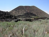
, on the edge of the Dixie National Forest
. It lies along State Route 18
north of the city of St. George
, the county seat
of Washington County. Its elevation is 4485 feet (1,367 m). Although Veyo is unincorporated, it has a post office
, with the ZIP code
of 84782. The population was 483 at the 2010 census. One tradition says the community name is an acronym of virtue, enterprise, youth, and order; another says it combines verdure and youth.
Veyo became a distinct community from Gunlock
in 1918.
Census-designated place
A census-designated place is a concentration of population identified by the United States Census Bureau for statistical purposes. CDPs are delineated for each decennial census as the statistical counterparts of incorporated places such as cities, towns and villages...
] in western Washington County
Washington County, Utah
As of the census of 2000, there were 90,354 people, 29,939 households, and 23,442 families residing in the county. The population density was 37 people per square mile . There were 36,478 housing units at an average density of 15 per square mile...
, Utah
Utah
Utah is a state in the Western United States. It was the 45th state to join the Union, on January 4, 1896. Approximately 80% of Utah's 2,763,885 people live along the Wasatch Front, centering on Salt Lake City. This leaves vast expanses of the state nearly uninhabited, making the population the...
, United States
United States
The United States of America is a federal constitutional republic comprising fifty states and a federal district...
, on the edge of the Dixie National Forest
Dixie National Forest
Dixie National Forest is a United States National Forest in Utah with headquarters in Cedar City. It occupies almost two million acres and stretches for about 170 miles across southern Utah. The largest national forest in Utah, it straddles the divide between the Great Basin and the Colorado River...
. It lies along State Route 18
Utah State Route 18
State Route 18 is a state highway in southern Utah, running for in Washington and Iron Counties from St. George to Beryl Junction. It forms part of the Legacy Loop Highway from St. George to Parowan. The highway closely follows the route of the Old Spanish Trail through Dixie National Forest.-St...
north of the city of St. George
St. George, Utah
St. George is a city located in the southwestern part of the U.S. state of Utah, and the county seat of Washington County, Utah. It is the principal city of and is included in the St. George, Utah, Metropolitan Statistical Area. The city is 119 miles northeast of Las Vegas, Nevada, and 303 miles ...
, the county seat
County seat
A county seat is an administrative center, or seat of government, for a county or civil parish. The term is primarily used in the United States....
of Washington County. Its elevation is 4485 feet (1,367 m). Although Veyo is unincorporated, it has a post office
Post office
A post office is a facility forming part of a postal system for the posting, receipt, sorting, handling, transmission or delivery of mail.Post offices offer mail-related services such as post office boxes, postage and packaging supplies...
, with the ZIP code
ZIP Code
ZIP codes are a system of postal codes used by the United States Postal Service since 1963. The term ZIP, an acronym for Zone Improvement Plan, is properly written in capital letters and was chosen to suggest that the mail travels more efficiently, and therefore more quickly, when senders use the...
of 84782. The population was 483 at the 2010 census. One tradition says the community name is an acronym of virtue, enterprise, youth, and order; another says it combines verdure and youth.
Veyo became a distinct community from Gunlock
Gunlock, Utah
Gunlock is an unincorporated community in western Washington County, Utah, United States, north of Gunlock State Park. It lies along local roads northwest of the city of St. George, the county seat of Washington County. Its elevation is 3,658 feet...
in 1918.