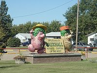
Vauxhall, Alberta
Encyclopedia
Vauxhall is a town in southern Alberta
Southern Alberta
Southern Alberta is a region located in the Canadian province of Alberta. As of the year 2004, the region's population was approximately 272,017. The primary cities are Lethbridge and Medicine Hat...
, Canada
Canada
Canada is a North American country consisting of ten provinces and three territories. Located in the northern part of the continent, it extends from the Atlantic Ocean in the east to the Pacific Ocean in the west, and northward into the Arctic Ocean...
. It is located in the Municipal District of Taber
Taber, Alberta (municipal district)
The Municipal District of Taber is a municipal district in southern Alberta, Canada. It is located in Census Division 2.-Demographics:The population of the Municipal District of Taber according to its 2008 municipal census is 6,714....
, in the prairie land between Bow River
Bow River
The Bow River is a river in the Canadian province of Alberta. It is a tributary of the South Saskatchewan River, and is considered the headwater of the Nelson River....
and Oldman River
Oldman River
The Oldman River is a river in southern Alberta, Canada. It flows roughly west to east from the Rocky Mountains, through the communities of Fort Macleod, Lethbridge, Taber, and on to Grassy Lake, where it joins with the Bow River to form the South Saskatchewan River, which eventually drains into...
.
It is situated 114 km (70.8 mi) west of Medicine Hat
Medicine Hat, Alberta
Medicine Hat, known to locals as "The Hat", is a city of 61,097 people located in the southeastern part of the province of Alberta, Canada. It is enclaved within Cypress County along with the nearby Town of Redcliff, although neither is part of the county....
on Highway 36 (Veteran Memorial Highway), 36 km (22.4 mi) north of Taber and 69 km (42.9 mi) south of Brooks
Brooks, Alberta
Brooks is a city in southeast Alberta, Canada surrounded by the County of Newell. It is located on Highway 1 and the Canadian Pacific Railway, approximately southeast of Calgary, and northwest of Medicine Hat. The city has an elevation of .- History :The area that is now Brooks was originally...
.
The town is served by the Vauxhall Airport
Vauxhall Airport
Vauxhall Airport, , is located south southeast of Vauxhall, Alberta, Canada.-External links:* on COPA's Places to Fly airport directory...
, located 5 kilometres (3.1 mi) south of the town.
Demographics
The town population as of 2001 was 1,112.In 2006, Vauxhall had a population of 1,069 living in 449 dwellings
House
A house is a building or structure that has the ability to be occupied for dwelling by human beings or other creatures. The term house includes many kinds of different dwellings ranging from rudimentary huts of nomadic tribes to free standing individual structures...
, a 3.9% decrease from 2001. The town has a land area of 2.88 km² (1.1 sq mi) and a population density
Population density
Population density is a measurement of population per unit area or unit volume. It is frequently applied to living organisms, and particularly to humans...
of 371.5 /km2.
Mascots