
Vail Pass
Encyclopedia
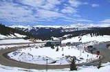
Vail Pass is a 10617 feet (3,236.1 m) high mountain pass
in the Rocky Mountains
of central Colorado
. The pass was named for Charles Vail, a highway engineer.
Vail Pass lies on the boundary between Eagle
and Summit
counties, between Vail
on the west and Copper Mountain
on the east. It provides the route of Interstate 70
(and earlier U.S. Highway 6) between the upper basins of the Eagle River
and the Blue River
, both tributaries of the Colorado River. Black Gore Creek, a tributary of Gore Creek
, in the watershed of the Eagle, descends from the north side of the pass towards the town of Vail. West Tenmile Creek, in the watershed of the Blue, descends from the south side. The pass is significantly steep on either side (7 to 8%), and two runaway truck ramps are available on the west bound side for trucks.
The pass was not a traditional historical route of the Rockies. Prior to 1940, the most common route westward was over nearby Shrine Pass
, just to the south, which leads to the town of the Red Cliff
in the upper Eagle Valley. In 1940, the construction of U.S. Highway 6 bypassed Shrine Pass in favor of the current route to the valley of Gore Creek.
Mountain pass
A mountain pass is a route through a mountain range or over a ridge. If following the lowest possible route, a pass is locally the highest point on that route...
in the Rocky Mountains
Rocky Mountains
The Rocky Mountains are a major mountain range in western North America. The Rocky Mountains stretch more than from the northernmost part of British Columbia, in western Canada, to New Mexico, in the southwestern United States...
of central Colorado
Colorado
Colorado is a U.S. state that encompasses much of the Rocky Mountains as well as the northeastern portion of the Colorado Plateau and the western edge of the Great Plains...
. The pass was named for Charles Vail, a highway engineer.
Vail Pass lies on the boundary between Eagle
Eagle County, Colorado
Eagle County is the thirteenth most populous of the 64 counties of the State of Colorado in the United States. The county is named for the Eagle River. The county population was 41,659 at U.S. Census 2000. The county seat is the Town of Eagle...
and Summit
Summit County, Colorado
Summit County is the 19th most populous of the 64 counties of the state of Colorado of the United States. The county population was 23,538 at U.S. Census 2000. The county seat is Breckenridge...
counties, between Vail
Vail, Colorado
The Town of Vail is a Home Rule Municipality in Eagle County, Colorado, United States. The population of the town was 4,589 in 2005. The town was established and built as the base village to Vail Ski Resort, with which it was originally conceived...
on the west and Copper Mountain
Copper Mountain, Colorado
Copper Mountain is a census-designated place in Summit County, Colorado, United States. Its elevation is 9,695 feet , and it is located at ....
on the east. It provides the route of Interstate 70
Interstate 70
Interstate 70 is an Interstate Highway in the United States that runs from Interstate 15 near Cove Fort, Utah, to a Park and Ride near Baltimore, Maryland. It was the first Interstate Highway project in the United States. I-70 approximately traces the path of U.S. Route 40 east of the Rocky...
(and earlier U.S. Highway 6) between the upper basins of the Eagle River
Eagle River (Colorado)
The Eagle River is a tributary of the Colorado River, approximately long, in west central Colorado in the United States.It rises in southeastern Eagle County, at the continental divide, and flows northwest past Gilman, Minturn, Avon...
and the Blue River
Blue River (Colorado)
The Blue River is a tributary of the Colorado River, approximately long, in the U.S. state of Colorado.It rises in southern Summit County, on the western side of the continental divide in the Ten Mile Range, near Quandary Peak. It flows north past Blue River and Breckenridge, then through the...
, both tributaries of the Colorado River. Black Gore Creek, a tributary of Gore Creek
Gore Creek (Colorado)
Gore Creek is a tributary of the Eagle River, approximately long, in Eagle County in central Colorado in the United States. It drains an area of the Rocky Mountains at the south end of the Gore Range through Vail Valley. It rises on the Eagle County-Summit County border along the high crest of the...
, in the watershed of the Eagle, descends from the north side of the pass towards the town of Vail. West Tenmile Creek, in the watershed of the Blue, descends from the south side. The pass is significantly steep on either side (7 to 8%), and two runaway truck ramps are available on the west bound side for trucks.
The pass was not a traditional historical route of the Rockies. Prior to 1940, the most common route westward was over nearby Shrine Pass
Shrine Pass
Shrine Pass is a high mountain pass in the Rocky Mountains of central Colorado in the United States.The pass is located at the northern end of the Sawatch Range, along the border of Eagle and Summit counties west of Frisco and just northwest of Vail Pass...
, just to the south, which leads to the town of the Red Cliff
Red Cliff, Colorado
Red Cliff is a Statutory Town in Eagle County, Colorado, United States. The population was 289 at the 2000 census. The town is a former mining camp situated in the canyon of the upper Eagle River just off U.S. Highway 24 north of Tennessee Pass...
in the upper Eagle Valley. In 1940, the construction of U.S. Highway 6 bypassed Shrine Pass in favor of the current route to the valley of Gore Creek.