

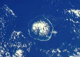
Utupua Island
Encyclopedia
Santa Cruz Islands
The Santa Cruz Islands are a group of islands in the Pacific Ocean, part of Temotu Province of the Solomon Islands. They lie approximately 250 miles to the southeast of the Solomon Islands Chain...
, located 66 km to the Southeast of the main Santa Cruz group, between Vanikoro and Santa Cruz proper. This island belongs administratively to the Temotu Province
Temotu Province
Temotu is the easternmost province of the Solomon Islands. The province was formerly known as Santa Cruz Islands Province. It consists, essentially, of two chains of islands which run parallel to each other from the northwest to the southeast.- Islands :...
of the Solomon Islands
Solomon Islands
Solomon Islands is a sovereign state in Oceania, east of Papua New Guinea, consisting of nearly one thousand islands. It covers a land mass of . The capital, Honiara, is located on the island of Guadalcanal...
.
Utupua is a high island surrounded by a coral reef. Its land surface is 69.0 km² and its highest point 380 m.
Utupua has a population of 848 inhabitants (1999 census) scattered in small villages. The main villages in the island are: Avita, Malombo, Tanimbili, Apakho and Nembao.