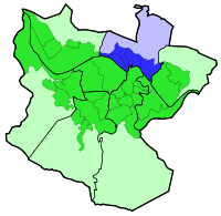
Uribarri
Encyclopedia


Bilbao
Bilbao ) is a Spanish municipality, capital of the province of Biscay, in the autonomous community of the Basque Country. With a population of 353,187 , it is the largest city of its autonomous community and the tenth largest in Spain...
, Basque Country
Basque Country (autonomous community)
The Basque Country is an autonomous community of northern Spain. It includes the Basque provinces of Álava, Biscay and Gipuzkoa, also called Historical Territories....
(Spain
Spain
Spain , officially the Kingdom of Spain languages]] under the European Charter for Regional or Minority Languages. In each of these, Spain's official name is as follows:;;;;;;), is a country and member state of the European Union located in southwestern Europe on the Iberian Peninsula...
). It is divided into the neighbourhoods of Castaños, Matico-Ciudad Jardín, Uríbarri proper and Zurbaran-Arabella.
It has an area of 4.19 square kilometers and a population of 39,369 inhabitants.
History
For many years it was a rural area full of farms, belonging to the former parish of BegoñaBegoña
Begoña or more puristically but also more rarely spelled Begoina, meaning "the lower foot" , is a historical municipality of Biscay that was incorporated to Bilbao in 1925....
, as a result many street names in the district are former names of farms, like Trauko.
This district includes the quarter of La Salve
La Salve
La Salve is a quarter in the 2nd district of the city of Bilbao, Spain. It gains its name from the fact that sailors, returning from sea, would first see the tower of the Basilica of Begoña at this point as ships returned up the river Nervión, which runs through the city...
, of historical importance for Bilbao as it was a traditional point for sailors returning to the city.
The area close to the Estuary of Bilbao
Estuary of Bilbao
The Estuary of Bilbao lies at the common mouth of the rivers Nervion, Ibaizabal and Cadagua, that drain most of Biscay and part of Alava in the Basque Country, Spain. It is a large estuary long that extends from Bilbao to the Bilbao Abra bay, a widening that makes the final transition between...
was urbanized in the late 19th century, when the Paseo del Campo Volantin boulevard was created, lined with mansions of Bilbao's
bourgeoisie. The higher lands away from the estuary were urbanized in the 1960s, with high density buildings for working classes.
Places of interest
- Bilbao City HallBilbao City HallThe City Hall of Bilbao, Spain, is located on the right bank of the Estuary of Bilbao across the Puente del Ayuntamiento bascule bridge that links it to the central Abando district....
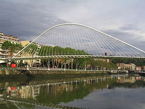
- ZubizuriZubizuriThe Zubizuri , also called the Campo Volantin Bridge or Puente del Campo Volantin, is a tied arch footbridge across the Nervion River in Bilbao, Spain...
bridge - Mount Artxanda
- Artxanda FunicularArtxanda FunicularThe Artxanda Funicular is a funicular railway in the city of Bilbao in Spain's Basque Country. It links downtown Bilbao with the recreational area at the summit of the nearby Artxanda Mountain, which has a park, several restaurants, a hotel, a sports complex, and offers panoramic views of the...

