

Uraga Channel
Encyclopedia
The is a waterway connecting Tokyo Bay
to the Sagami Gulf. It is an important channel for ships headed from Tokyo
, Yokohama
, and Chiba
to the Pacific Ocean
and beyond.
 The Uraga channel is at the southern end of Tokyo Bay (formerly known as Edo Bay, prior to 1868).
Tokyo Bay is surrounded by the Bōsō Peninsula
(Chiba Prefecture
) to the east and the Miura Peninsula
(Kanagawa Prefecture
) to the west. In a narrow sense, Tokyo Bay is the area north of the straight line formed by the on the Miura Peninsula on one end and on the Boso Peninsula on the other end. This area covers about 922 km². Tokyo Bay, in a broader sense, would be understood to include the Uraga Channel as well (its southwestern demarcation being the straight line between the Tsurugisaki Lighthouse
and Sunosaki Lighthouse
); and the total area of the bay would then be 1320 km².
The city of Uraga
is located at the northern end of the channel on the Miura Peninsula. Due to its strategic location at the entrance of Edo Bay, Uraga has often been the first point of contact between visiting foreign ships and Japan.
At its narrowest, between Cape Kannon and Futtsu Point, the channel is 6 km wide. During the late Edo period
, it was defended against foreign ships by twelve artillery batteries on both the Bōsō Peninsula
and Miura Peninsula
.
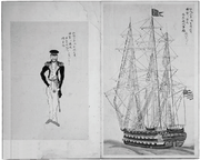 In 1846, Captain James Biddle
of the U.S. Navy anchored two warships, the U.S.S. Columbus and the U.S.S. Vincennes in Uraga Channel at the mouth to Tokyo Bay. This was a step in what turned out to be an unsuccessful effort to open Japan to trade with the United States.
On July 14, 1853, Commodore Perry lowered the anchor of the squadron the Japanese called the Black ships
near Uraga at Kurihama (in present-day Yokosuka
in Kanagawa Prefecture
) at the mouth of the channel. On the return of the Commodore's squadron in 1854, the ships by-passed Uraga to anchor closer to Edo at Kanagawa, which is where the city of Yokohama now stands.
Tokyo Bay
is a bay in the southern Kantō region of Japan. Its old name was .-Geography:Tokyo Bay is surrounded by the Bōsō Peninsula to the east and the Miura Peninsula to the west. In a narrow sense, Tokyo Bay is the area north of the straight line formed by the on the Miura Peninsula on one end and on...
to the Sagami Gulf. It is an important channel for ships headed from Tokyo
Tokyo
, ; officially , is one of the 47 prefectures of Japan. Tokyo is the capital of Japan, the center of the Greater Tokyo Area, and the largest metropolitan area of Japan. It is the seat of the Japanese government and the Imperial Palace, and the home of the Japanese Imperial Family...
, Yokohama
Yokohama
is the capital city of Kanagawa Prefecture and the second largest city in Japan by population after Tokyo and most populous municipality of Japan. It lies on Tokyo Bay, south of Tokyo, in the Kantō region of the main island of Honshu...
, and Chiba
Chiba, Chiba
is the capital city of Chiba Prefecture, Japan. It is located approximately 40 km east of the center of Tokyo on Tokyo Bay. Chiba City became a government designated city in 1992. Its population as of 2008 is approximately 960,000....
to the Pacific Ocean
Pacific Ocean
The Pacific Ocean is the largest of the Earth's oceanic divisions. It extends from the Arctic in the north to the Southern Ocean in the south, bounded by Asia and Australia in the west, and the Americas in the east.At 165.2 million square kilometres in area, this largest division of the World...
and beyond.
Geography
Tokyo Bay is surrounded by the Bōsō Peninsula
Boso Peninsula
thumb|Locationthumb|Landsat image with high-resolution data from Space Shuttle is a peninsula in Chiba prefecture on Honshū, the largest island of Japan. It forms the eastern edge of Tokyo Bay, separating it from the Pacific Ocean....
(Chiba Prefecture
Chiba Prefecture
is a prefecture of Japan located in the Kantō region and the Greater Tokyo Area. Its capital is Chiba City.- History :Chiba Prefecture was established on June 15, 1873 with the merger of Kisarazu Prefecture and Inba Prefecture...
) to the east and the Miura Peninsula
Miura Peninsula
is a peninsula located in Kanagawa, Japan. It lies south of Yokohama and Tokyo and divides Tokyo Bay, to the east, from Sagami Bay, to the west. Cities and towns on the Miura Peninsula include Yokosuka, Miura, Hayama, Zushi, and Kamakura....
(Kanagawa Prefecture
Kanagawa Prefecture
is a prefecture located in the southern Kantō region of Japan. The capital is Yokohama. Kanagawa is part of the Greater Tokyo Area.-History:The prefecture has some archaeological sites going back to the Jōmon period...
) to the west. In a narrow sense, Tokyo Bay is the area north of the straight line formed by the on the Miura Peninsula on one end and on the Boso Peninsula on the other end. This area covers about 922 km². Tokyo Bay, in a broader sense, would be understood to include the Uraga Channel as well (its southwestern demarcation being the straight line between the Tsurugisaki Lighthouse
Tsurugisaki Lighthouse
is a lighthouse located on Cape Tsurugi on the southeastern extremity of the city of Miura, Kanagawa Prefecture, Japan on the southernmost and eastern tip of Miura Peninsula...
and Sunosaki Lighthouse
Sunosaki Lighthouse
) is a lighthouse located in the city of Tateyama, Chiba Prefecture, Japan at the southern tip of the Bōsō Peninsula.Sunosaki Lighthouse was first lit on December 15, 1919, and completes the navigational aid systems for all vessels entering the Uraga Channel and Tokyo Bay, with the Kannonzaki...
); and the total area of the bay would then be 1320 km².
The city of Uraga
Uraga
is a subdivision of the city of Yokosuka, Kanagawa Prefecture, Japan. It is located on the south eastern side of the Miura Peninsula, at the northern end of the Uraga Channel, at the entrance of Tokyo Bay.-History:...
is located at the northern end of the channel on the Miura Peninsula. Due to its strategic location at the entrance of Edo Bay, Uraga has often been the first point of contact between visiting foreign ships and Japan.
At its narrowest, between Cape Kannon and Futtsu Point, the channel is 6 km wide. During the late Edo period
Edo period
The , or , is a division of Japanese history which was ruled by the shoguns of the Tokugawa family, running from 1603 to 1868. The political entity of this period was the Tokugawa shogunate....
, it was defended against foreign ships by twelve artillery batteries on both the Bōsō Peninsula
Boso Peninsula
thumb|Locationthumb|Landsat image with high-resolution data from Space Shuttle is a peninsula in Chiba prefecture on Honshū, the largest island of Japan. It forms the eastern edge of Tokyo Bay, separating it from the Pacific Ocean....
and Miura Peninsula
Miura Peninsula
is a peninsula located in Kanagawa, Japan. It lies south of Yokohama and Tokyo and divides Tokyo Bay, to the east, from Sagami Bay, to the west. Cities and towns on the Miura Peninsula include Yokosuka, Miura, Hayama, Zushi, and Kamakura....
.
History
James Biddle
James Biddle , of the Biddle family, brother of financier Nicholas Biddle and nephew of Captain Nicholas Biddle, was an American commodore. His flagship was USS Columbus.-Education and early career:...
of the U.S. Navy anchored two warships, the U.S.S. Columbus and the U.S.S. Vincennes in Uraga Channel at the mouth to Tokyo Bay. This was a step in what turned out to be an unsuccessful effort to open Japan to trade with the United States.
On July 14, 1853, Commodore Perry lowered the anchor of the squadron the Japanese called the Black ships
Black Ships
The Black Ships was the name given to Western vessels arriving in Japan in the 16th and 19th centuries.In 1543 Portuguese initiated the first contacts, establishing a trade route linking Goa to Nagasaki...
near Uraga at Kurihama (in present-day Yokosuka
Yokosuka, Kanagawa
is a city located in Kanagawa, Japan. As of 2010, the city had an estimated population of 419,067 and a population density of 4,160 people per km². It covered an area of 100.62 km²...
in Kanagawa Prefecture
Kanagawa Prefecture
is a prefecture located in the southern Kantō region of Japan. The capital is Yokohama. Kanagawa is part of the Greater Tokyo Area.-History:The prefecture has some archaeological sites going back to the Jōmon period...
) at the mouth of the channel. On the return of the Commodore's squadron in 1854, the ships by-passed Uraga to anchor closer to Edo at Kanagawa, which is where the city of Yokohama now stands.
External links
- Maritime Traffic, 3rd Regional Coast Guard Headquarters: Uraga Suido Traffic Route
- National Archives of JapanNational Archives of JapanThe preserve Japanese government documents and historical records and make them available to the public. Although Japan's reverence for its unique history and art is well documented and illustrated by collections of art and documents, there is almost no archivist tradition...
, Digital Gallery: Marine survey chart: Tokyo bay, Kuwanonsaki to Koshiba, published 1876