

University Heights, San Diego, California
Encyclopedia
University Heights is a neighborhood in Central San Diego, California
centered around Park Boulevard and Adams Avenue. The area is filled with a number of restaurants, coffee shops, boutiques, and artist's studios primarily on Park Boulevard and Adams Avenue. Live entertainment can be found most nights. Adjacent to Hillcrest
and Normal Heights
, additional restaurants, bars, coffee shops, and night clubs are within easy reach.
The neighborhood sits in a central San Diego location with a broad spectrum of housing options, from cottages, apartments and condominiums, to million-dollar homes. Downtown, Balboa Park, San Diego Airport
, Mission Valley
, San Diego State University
, are only a few minutes away.
On the far northern edge of this mesa, at the scenic rim of Mission Valley, an ostrich farm and public garden spot was constructed near what is now the corner of Adams Avenue and Park Boulevard. The little neighborhood of homes subsequently built on the site is still called Mission Cliff Gardens and still sports the original garden boundary wall of rounded stones. The gardens were a popular tourist site.
In the 1910s, University Heights became one of the many San Diego neighborhoods connected by the Class 1 streetcars
and an extensive San Diego public transit system that was spurred by the Panama-California Exposition of 1915 and built by John D. Spreckels
. Built in part to exclusively serve Mission Cliff Gardens, these streetcars became a fixture of this neighborhood until their retirement in 1939.
between Madison Ave. and Monroe Ave., has been designated a historic district by the City of San Diego for its 1920s Spanish Colonial Revival bungalows.
In 1996 the City of San Diego awarded the construction project to Young Electric Sign Company
(YESCO). On April 3, 2007 the sign was unveiled and illuminated for the first time during a community celebration. The ribbon was cut by then Mayor Susan Golding and several dignitaries were on hand. The sign serves to day as a local landmark and identity for the University Heights community.
San Diego, California
San Diego is the eighth-largest city in the United States and second-largest city in California. The city is located on the coast of the Pacific Ocean in Southern California, immediately adjacent to the Mexican border. The birthplace of California, San Diego is known for its mild year-round...
centered around Park Boulevard and Adams Avenue. The area is filled with a number of restaurants, coffee shops, boutiques, and artist's studios primarily on Park Boulevard and Adams Avenue. Live entertainment can be found most nights. Adjacent to Hillcrest
Hillcrest, San Diego, California
Hillcrest is a neighborhood in San Diego, California northwest of Balboa Park and south of Mission Valley.Hillcrest is known for its tolerance, diversity, and locally-owned businesses, including restaurants, cafés, bars, clubs, trendy thrift-stores, and other independent specialty stores...
and Normal Heights
Normal Heights, San Diego, California
Normal Heights is a neighborhood of the mid-city region of San Diego, California. It is known for its affordable pubs, restaurants, coffee houses, antique shops, book shops, and burgeoning arts community.-History:...
, additional restaurants, bars, coffee shops, and night clubs are within easy reach.
The neighborhood sits in a central San Diego location with a broad spectrum of housing options, from cottages, apartments and condominiums, to million-dollar homes. Downtown, Balboa Park, San Diego Airport
San Diego International Airport
San Diego International Airport , sometimes referred to as Lindbergh Field, is a public airport located northwest of the central business district of San Diego, California and from the Mexico – United States border at Tijuana, Mexico...
, Mission Valley
Mission Valley, California
Mission Valley is a wide river valley trending east-west in San Diego, California, through which the San Diego River flows to the Pacific Ocean...
, San Diego State University
San Diego State University
San Diego State University , founded in 1897 as San Diego Normal School, is the largest and oldest higher education facility in the greater San Diego area , and is part of the California State University system...
, are only a few minutes away.
History
The name "University" (both for the neighborhood and nearby University Avenue) derives from a plan, originally boosted during the land boom of the 1880s, to build a university in the area, to be located on a tract of land later used for the State Normal School (predecessor to San Diego State College). The headquarters of San Diego Unified School district currently occupies the site near the corner of El Cajon and Park Boulevards.On the far northern edge of this mesa, at the scenic rim of Mission Valley, an ostrich farm and public garden spot was constructed near what is now the corner of Adams Avenue and Park Boulevard. The little neighborhood of homes subsequently built on the site is still called Mission Cliff Gardens and still sports the original garden boundary wall of rounded stones. The gardens were a popular tourist site.
In the 1910s, University Heights became one of the many San Diego neighborhoods connected by the Class 1 streetcars
San Diego Class 1 Streetcars
The San Diego Class 1 Streetcars were a fleet of twenty-four unique streetcars that were originally built to provide transportation for the Panama-California Exposition in Balboa Park. The cars were designed by the San Diego Electric Railway Company under the leadership of John D. Spreckels and...
and an extensive San Diego public transit system that was spurred by the Panama-California Exposition of 1915 and built by John D. Spreckels
John D. Spreckels
John Diedrich Spreckels , the son of German-American industrialist Claus Spreckels, founded a transportation and real estate empire in San Diego, California in the late 19th and early 20th centuries...
. Built in part to exclusively serve Mission Cliff Gardens, these streetcars became a fixture of this neighborhood until their retirement in 1939.
Architecture and Historic Districts
Shirley Ann PlaceShirley Ann Place
The Shirley Ann Place Historic District is located in the University Heights neighborhood of San Diego, California. The block between Madison Ave. and Monroe Ave...
between Madison Ave. and Monroe Ave., has been designated a historic district by the City of San Diego for its 1920s Spanish Colonial Revival bungalows.
Parks
Trolley Barn Park on Adams Avenue, just east of Park Boulevard, is popular with young families and hosts free concerts on Friday evenings during the summer. This park, as noted by its name, was the site of the "trolley barn" where trolley cars went for repairs and down time until the system was replaced by busses in the 1950s. Sidewalks around the playground in the park are laid out in a pattern mimicking the local street plan, a design also echoed on the carved stone plaque. The majority of the streets in the area are named after states and past Presidents.Street Sign
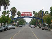
In 1994 community development funds were allocated to construct a street overhead sign. In 1995 a contest was held calling for entries from local artists for the street sign design. Kevin Whaley's winning concept design was unveiled at the University Heights Community Association meeting. The design incorpoarted historical elemnts from the past and present within the community.In 1996 the City of San Diego awarded the construction project to Young Electric Sign Company
Young Electric Sign Company
Young Electric Sign Company is a privately owned manufacturer of electric signs based in Salt Lake City. The company was founded by Thomas Young in 1920 and today has divisions and branches in 10 western states, as well as in Louisiana, Mississippi and Texas...
(YESCO). On April 3, 2007 the sign was unveiled and illuminated for the first time during a community celebration. The ribbon was cut by then Mayor Susan Golding and several dignitaries were on hand. The sign serves to day as a local landmark and identity for the University Heights community.
External links
- University Heights Community Association
- University Heights Community Development Corporation
- University Heights Arts Association
- GayCities San Diego: University Heights Guide to Gay Bars & Clubs in University Heights
- Between Heights Community
- New To San Diego University Heights Map