

Umtanum Ridge Water Gap
Encyclopedia
United States
The United States of America is a federal constitutional republic comprising fifty states and a federal district...
.
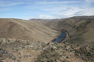
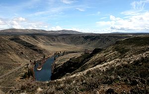
The Umtanum Ridge Water is a water gap
Water gap
A water gap is an opening or notch which flowing water has carved through a mountain range. Water gaps often offer a practical route for road and rail transport to cross mountain ridges.- Geology :...
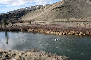
cut by the Yakima River
Yakima River
The Yakima River is a tributary of the Columbia River in south central and eastern Washington State, named for the indigenous Yakama people. The length of the river from headwaters to mouth is , with an average drop of .-Course:...
through Manastash
Manastash Ridge
Manastash Ridge is a long anticline mountain ridge located in central Washington state in the United States. Manastash Ridge runs mostly west-to-east in Kittitas and Yakima counties, for approximately 50 miles...
and Umtanum Ridge
Umtanum Ridge
Umtanum Ridge is a long anticline mountain ridge in Yakima County and Kittitas County in the U.S. state of Washington. It runs for approximately 55 miles east-southeast from the Cascade Range, through the Yakima Training Center to the edge of the Columbia River at Priest Rapids Dam and Hanford Reach...
anticline
Anticline
In structural geology, an anticline is a fold that is convex up and has its oldest beds at its core. The term is not to be confused with antiform, which is a purely descriptive term for any fold that is convex up. Therefore if age relationships In structural geology, an anticline is a fold that is...
s, which are part of the Yakima Fold Belt near the western edge of the Columbia River Plateau
Columbia River Plateau
The Columbia Plateau is a geologic and geographic region that lies across parts of the U.S. states of Washington, Oregon, and Idaho. It is a wide flood basalt plateau between the Cascade Range and the Rocky Mountains, cut through by the Columbia River...
located in central Washington. This National Natural Landmark
National Natural Landmark
The National Natural Landmark program recognizes and encourages the conservation of outstanding examples of the natural history of the United States. It is the only natural areas program of national scope that identifies and recognizes the best examples of biological and geological features in...
is characterized by a series of steep-sided ridges in the Columbia River basalt
Columbia River Basalt Group
The Columbia River Basalt Group is a large igneous province that lies across parts of the Western United States. It is found in the U.S. states of Washington, Oregon, Idaho, Nevada, and California...
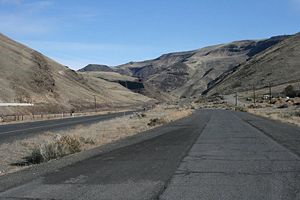
which are cut through axially by the Yakima River. It is also referred to as the Yakima River Canyon, and is located between the cities of Ellensburg
Ellensburg, Washington
Ellensburg is a city in, and the county seat of, Kittitas County, Washington, United States. The population was 18,174 at the 2010 census. The population was 18,250 at 2011 Estimate from Office of Financial Management. Ellensburg is located just east of the Cascade Range on I-90 and is known as the...
and Yakima
Yakima, Washington
Yakima is an American city southeast of Mount Rainier National Park and the county seat of Yakima County, Washington, United States, and the eighth largest city by population in the state itself. As of the 2010 census, the city had a total population of 91,196 and a metropolitan population of...
. Washington State Route 821
Washington State Route 821
State Route 821, also known as Canyon Road, is a state highway in Washington. It runs from an intersection with Interstate 82 north of Selah to another junction with I-82 south of Ellensburg. The total length of SR 821 is .-Route description:...
, originally the main route between Ellensburg and Yakima, parallels the river through the canyon.
Geologic history
Fold (geology)
The term fold is used in geology when one or a stack of originally flat and planar surfaces, such as sedimentary strata, are bent or curved as a result of permanent deformation. Synsedimentary folds are those due to slumping of sedimentary material before it is lithified. Folds in rocks vary in...
into ridges (anticline
Anticline
In structural geology, an anticline is a fold that is convex up and has its oldest beds at its core. The term is not to be confused with antiform, which is a purely descriptive term for any fold that is convex up. Therefore if age relationships In structural geology, an anticline is a fold that is...
s) and valleys (syncline
Syncline
In structural geology, a syncline is a fold, with younger layers closer to the center of the structure. A synclinorium is a large syncline with superimposed smaller folds. Synclines are typically a downward fold, termed a synformal syncline In structural geology, a syncline is a fold, with younger...
s) running roughly east-west as a result of north-south compression. On its way to join the Columbia River, the Yakima River cuts from the Kittitas Valley southward through four major ridges formed by this compression: the Manastash Ridge, the Umtanum Ridge, the Yakima Ridge
Yakima Ridge
Yakima Ridge is a long anticline mountain ridge in Yakima County and Benton County in the U.S. state of Washington. From its western end just north of the city of Yakima, the ridge runs east-southeast through the Yakima Training Center to its eastern end at Hanford Reach National Monument and the...
, and the Ahtanum Ridge
Ahtanum Ridge
Ahtanum Ridge is a long anticline mountain ridge in Yakima County in the U.S. state of Washington. It is located just south of the city of Yakima....
to reach the Yakima Valley.
Meander
A meander in general is a bend in a sinuous watercourse. A meander is formed when the moving water in a stream erodes the outer banks and widens its valley. A stream of any volume may assume a meandering course, alternately eroding sediments from the outside of a bend and depositing them on the...
s, they tend to be preserved in rock as the river eats into a rising anticline.
Locations
| Location | Coordinates |
|---|---|
| Manastash Ridge | 46°51′27"N 120°23′00"W |
| Umtanum Ridge at the point where it bifurcates into north & south ridges | 46°51′00"N 120°32′40"W |
| Umtanum Water Gap of the Yakima Canyon | 46°48′38"N 120°26′40"W |