
Uley Long Barrow
Encyclopedia
Neolithic
The Neolithic Age, Era, or Period, or New Stone Age, was a period in the development of human technology, beginning about 9500 BC in some parts of the Middle East, and later in other parts of the world. It is traditionally considered as the last part of the Stone Age...
burial mound, near the village of Uley
Uley
Uley is a village in the county of Gloucestershire, England. It is situated in a wooded valley in the Cotswold escarpment, on the road between Dursley and Stroud. The population is around 1,100, but was much greater during the early years of the industrial revolution, when the village was...
, Gloucestershire
Gloucestershire
Gloucestershire is a county in South West England. The county comprises part of the Cotswold Hills, part of the flat fertile valley of the River Severn, and the entire Forest of Dean....
, England
England
England is a country that is part of the United Kingdom. It shares land borders with Scotland to the north and Wales to the west; the Irish Sea is to the north west, the Celtic Sea to the south west, with the North Sea to the east and the English Channel to the south separating it from continental...
. Although typically described as a long barrow
Long barrow
A long barrow is a prehistoric monument dating to the early Neolithic period. They are rectangular or trapezoidal tumuli or earth mounds traditionally interpreted as collective tombs...
, the mound is actually a transected gallery grave
Gallery grave
A Gallery grave is a form of Megalithic tomb where there is no size difference between the burial chamber itself and the entrance passage. Two parallel walls of stone slabs were erected to form a corridor and covered with a line of capstones. The rectangular tomb was covered with a barrow or a cairn...
. It was probably built before 3000 BC.
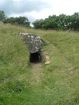
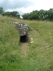
It is about 180 feet (54.9 m) in length and contains a stone built central passage with two chambers on either side and another at the end. The earthen mound is surrounded by a dry-stone revetting wall
Revetment
Revetments, or revêtements , have a variety of meanings in architecture, engineering and art history. In stream restoration, river engineering or coastal management, they are sloping structures placed on banks or cliffs in such a way as to absorb the energy of incoming water...
. To the east of the mound is a deep forecourt.
The barrow was archaeologically excavated in 1821, revealing the remains of 15 skeletons and a later, intrusive Roman age
Roman Britain
Roman Britain was the part of the island of Great Britain controlled by the Roman Empire from AD 43 until ca. AD 410.The Romans referred to the imperial province as Britannia, which eventually comprised all of the island of Great Britain south of the fluid frontier with Caledonia...
burial above the northeast chamber. It was excavated again in 1854.
The mound is named after Hester, wife of the 17th century landowner Henry Pegler. Hester died in 1694, and Henry in 1695. It is clearly sign-posted from the side of the nearby Crawley Hill (B4066 road) between Uley and Nympsfield
Nympsfield
Nympsfield is a village and civil parish in the English county of Gloucestershire. It is located around six miles south-west of the town of Stroud. As well as Nympsfield village, the parish also contains the hamlet of Cockadilly....
. Access is by means of a grass track towards the wood and then a small footpath through a gap in the hedge. The barrow lies in the corner of the adjoining field next to the wood.
The entrance is currently blocked off, internal chambers cannot currently be accessed and will not be opened until essential health and safety work is carried out.