

U.S. Route 29 in the District of Columbia
Encyclopedia
U.S. Route 29
passes through the District of Columbia
between Arlington, Virginia
, and Silver Spring, Maryland
, predominantly along surface streets.
 From Virginia
, U.S. Route 29 enters the District of Columbia on the Key Bridge
. It then bypasses Georgetown
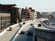
on the Whitehurst Freeway, an elevated highway
over K Street and Water Street in the Georgetown neighborhood. Route 29 then travels along K Street through downtown Washington
. From K Street, Route 29 turns left at 11th then right at Rhode Island Avenue, NW
. U.S. 29 northbound turns left at 7th Street NW, where it becomes Georgia Avenue NW. Route 29 follows Georgia Avenue out of the District and into Maryland
.
 Various alignments of Route 29 used to exist, including segments along New Hampshire Avenue
, Dupont Circle
, 16th Street
, and Alaska Avenue, N.W.
Prior to construction of the Whitehurst Freeway, the Georgetown waterfront experienced periods of prosperity and decline. The structure was built by engineer Archibald Alexander
. It was named after Herbert C. Whitehurst, an early director of the D.C. highway department.
has proposed replacing the present ramp from the northbound Key Bridge to the eastbound Whitehurst Freeway with a spiral ramp that would loop under the Key Bridge before connecting to eastbound K Street.
In 2007, Mayor Adrian Fenty
halted plans for an environmental impact study for the proposed demolition, stating that his administration is "not going to be spending money on this particular issue. You do not have to worry." The study would have cost nearly $1,000,000; the DC Department of Transportation spent more than $500,000 on a previous study that examined proposed alternatives to the highway.
.
U.S. Route 29
U.S. Route 29 is a north–south United States highway that runs for from the western suburbs of Baltimore, Maryland, to Pensacola, Florida. This highway's northern terminus is at Maryland Route 99 in Ellicott City, Maryland...
passes through the District of Columbia
Washington, D.C.
Washington, D.C., formally the District of Columbia and commonly referred to as Washington, "the District", or simply D.C., is the capital of the United States. On July 16, 1790, the United States Congress approved the creation of a permanent national capital as permitted by the U.S. Constitution....
between Arlington, Virginia
Arlington County, Virginia
Arlington County is a county in the Commonwealth of Virginia. The land that became Arlington was originally donated by Virginia to the United States government to form part of the new federal capital district. On February 27, 1801, the United States Congress organized the area as a subdivision of...
, and Silver Spring, Maryland
Silver Spring, Maryland
Silver Spring is an unincorporated area and census-designated place in Montgomery County, Maryland, United States. It had a population of 71,452 at the 2010 census, making it the fourth most populous place in Maryland, after Baltimore, Columbia, and Germantown.The urbanized, oldest, and...
, predominantly along surface streets.
Route description
Virginia
The Commonwealth of Virginia , is a U.S. state on the Atlantic Coast of the Southern United States. Virginia is nicknamed the "Old Dominion" and sometimes the "Mother of Presidents" after the eight U.S. presidents born there...
, U.S. Route 29 enters the District of Columbia on the Key Bridge
Francis Scott Key Bridge (Washington)
The Francis Scott Key Bridge, more commonly known as the Key Bridge, is a six-lane reinforced concrete arch bridge conveying U.S. Route 29 traffic across the Potomac River between the Rosslyn neighborhood of Arlington County, Virginia and the Georgetown neighborhood of Washington, D.C...
. It then bypasses Georgetown
Georgetown, Washington, D.C.
Georgetown is a neighborhood located in northwest Washington, D.C., situated along the Potomac River. Founded in 1751, the port of Georgetown predated the establishment of the federal district and the City of Washington by 40 years...
on the Whitehurst Freeway, an elevated highway
Highway
A highway is any public road. In American English, the term is common and almost always designates major roads. In British English, the term designates any road open to the public. Any interconnected set of highways can be variously referred to as a "highway system", a "highway network", or a...
over K Street and Water Street in the Georgetown neighborhood. Route 29 then travels along K Street through downtown Washington
Downtown Washington, D.C.
Downtown is a neighborhood of Washington, D.C., as well as a colloquial name for the central business district in the northwest quadrant of the city. Geographically, the area extends roughly five to six blocks west, northwest, north, northeast, and east of the White House...
. From K Street, Route 29 turns left at 11th then right at Rhode Island Avenue, NW
Rhode Island Avenue (Washington, D.C.)
Rhode Island Avenue is a diagonal avenue in the Northwest and Northeast quadrants of Washington, D.C. and the capital's inner suburbs in Prince George's County, Maryland. Paralleling New York Avenue, Rhode Island Avenue was one of the original streets in Pierre L'Enfant's plan for the capital. ...
. U.S. 29 northbound turns left at 7th Street NW, where it becomes Georgia Avenue NW. Route 29 follows Georgia Avenue out of the District and into Maryland
Maryland
Maryland is a U.S. state located in the Mid Atlantic region of the United States, bordering Virginia, West Virginia, and the District of Columbia to its south and west; Pennsylvania to its north; and Delaware to its east...
.
History
New Hampshire Avenue
New Hampshire Avenue is a diagonal street in Washington, D.C., beginning at the Kennedy Center and extending northeast for about 5 miles and then continuing into Maryland where it is designated Maryland Route 650. New Hampshire Avenue, however, is not contiguous...
, Dupont Circle
Dupont Circle
Dupont Circle is a traffic circle, park, neighborhood, and historic district in Northwest Washington, D.C. The traffic circle is located at the intersection of Massachusetts Avenue NW, Connecticut Avenue NW, New Hampshire Avenue NW, P Street NW, and 19th Street NW...
, 16th Street
16th Street Northwest (Washington, D.C.)
16th Street Northwest is a prominent north-south thoroughfare in the northwest quadrant of Washington, D.C.Part of Pierre L'Enfant's design for the city, 16th Street begins just north of the White House across Lafayette Park at H Street and continues due north in a straight line passing K Street,...
, and Alaska Avenue, N.W.
Prior to construction of the Whitehurst Freeway, the Georgetown waterfront experienced periods of prosperity and decline. The structure was built by engineer Archibald Alexander
Archie Alexander
Archie Alphonso Alexander was an African-American mathematician and engineer and an early African-American graduate of the University of Iowa. He was also a governor of the U.S. Virgin Islands....
. It was named after Herbert C. Whitehurst, an early director of the D.C. highway department.
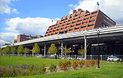
Proposed demolition
Redevelopment of the Georgetown waterfront began in 2008. Though the freeway was last rebuilt in a project ending in 1998, the Government of the District of Columbia has proposed demolishing the Whitehurst Freeway and upgrading K Street to a 4- or 6-lane through street. One engineering difficulty in doing so is to connect K Street to Canal Road, which is about 60 feet (18.3 m) above the waterfront. Another engineering difficulty is to connect K Street to the Key Bridge. To address the latter difficulty, architect Arthur Cotton MooreArthur Cotton Moore
Arthur Cotton Moore is an architect in Washington, D.C.. Born in 1935, he grew up in the Kalomara district of Washington, and after attending St. Albans School studied architecture at Princeton University. He received an Honor Award from the American Institute of Architects in 1977 and became a...
has proposed replacing the present ramp from the northbound Key Bridge to the eastbound Whitehurst Freeway with a spiral ramp that would loop under the Key Bridge before connecting to eastbound K Street.
In 2007, Mayor Adrian Fenty
Adrian Fenty
Adrian Malik Fenty was the sixth, and at age 36, the youngest, mayor of the District of Columbia. He served one term—from 2007 to 2011—losing his bid for reelection at the primary level to Democrat Vincent C. Gray...
halted plans for an environmental impact study for the proposed demolition, stating that his administration is "not going to be spending money on this particular issue. You do not have to worry." The study would have cost nearly $1,000,000; the DC Department of Transportation spent more than $500,000 on a previous study that examined proposed alternatives to the highway.
Proposed route
Interstate 266, if built, would have had either a junction or a concurrency with Route 29.Junctions
At the eastern terminus of the Whitehurst Freeway, Route 29 meets the eastern terminus of Interstate 66Interstate 66
Interstate 66 is an Interstate Highway in the eastern United States. As indicated by its even route number, it runs in an east–west direction. Its western terminus is at Middletown, Virginia, at an intersection with Interstate 81; its eastern terminus is in Washington, D.C., at an...
.
External links
- District Department of Transportation - Whitehurst Freeway Deconstruction Feasibility Study
- District Department of Transportation Historical Photo Archives - Whitehurst Freeway
- Lewis, Roger K. "Remove Whitehurst, and Behold the Potential -- and Pitfalls", The Washington Post, April 14, 2007
- District of Columbia Highway(s), from Yurasko.net