

U.S. Route 10 in Michigan
Encyclopedia
US Highway 10 is a part of the United States Numbered Highway System that runs from West Fargo, North Dakota
, to the Lower Peninsula
of the US state of Michigan
. The highway enters the state on the SS Badger crossing Lake Michigan
at Ludington
and ends at Bay City
.
US 10 was created as part of the original US Highway System in 1926. It replaced three state trunkline highways of the day: M-20
, M-24
and M-10
, running between Ludington on Lake Michigan
and downtown Detroit. It also ran concurrently
with US 23
between Saginaw
and Flint
. The highway has been realigned several times during the construction of Interstate 75
in southeast Michigan, even being temporarily designated "TO I-75" to connect segments of the I-75 freeway. The Michigan Department of Transportation
(MDOT) truncated the highway to Bay City in 1986.
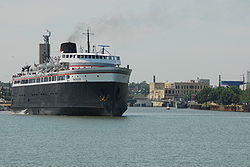 US 10 enters Michigan
after it crosses Lake Michigan
from Manitowoc, Wisconsin
to Ludington. Traffic is carried across the lake during the summer months on the SS Badger, a privately owned carferry. Heading eastward from the ferry, US 10 is concurrent with US 31
from Ludington
to Scottville
before US 31 heads north. The road then heads east through Baldwin
and Reed City
before it becomes a freeway west of US 127
near the junction with M-115. US 127 and US 10 overlap for a short distance near Clare
. US 10 bypasses Midland
and terminates at I-75
in Bay City
.
, M-24
and M-10
in use as far back as 1919. When the US Highway System was announced on November 11, 1926, US 10 replaced these designations. The highway started in Ludington and ran east replacing M-20 to Midland, M-24 to Saginaw
and M-10 to Detroit
. Between Saginaw and Flint, US 10 and US 23
were routed concurrently.
Two changes were made in the routing of US 10 by 1929. As shown on the maps of the time, US 10 was rerouted to bypass Flint
. The former routing through the city is redesigned M-10. A second change moved the highway to its present routing west of Baldwin to the Lake
–Mason
county line. A bypass of downtown Midland was opening in 1934. The previous routing through town was initially renumbered US 10A. A rerouting project in Osceola County
started in 1936. By the end of the year, a new roadway was opened between Sears and M-66
. Until the second segment of the project was completed two years later, US 10 was routed concurrently with M-66. When the new routing between M-66 and Lake in Clare County
was opened, that concurrency was eliminated and all the previous routings were transferred to local control.
By 1942, the M-10 designation in Flint was renumbered BUS US 10, eliminating the second M-10 designation from the maps. The last segments of US 10 that were gravel-surfaced were paved by 1948. The last section paved was between Chase and Reed City
.
A bypass of Saginaw was completed by 1953. This new roadway was designated as US 23 alone. The highway through downtown Saginaw was numbered US 10/BUS US 23. The Fenton–Clio Expressway was completed in 1957 from Birch Run
past Flint. The new expressway was numbered US 23, leaving the former highway through Flint as just US 10. A bypass of Reed City opened by 1960; the former routing was renumbered BUS US 10.
Many changes were made in 1960 to the routing of US 10. A new freeway opened for I-75/US 10/US 23 between M-13
northeast of Saginaw and the M-20 freeway in Bay City. US 10 replaced the M-20 designation on the freeway between Midland and Bay City. M-47
replaced US 10 between Midland and Saginaw, and M-81
replaced US 10 in the city of Saginaw. An addition segment of US 10 between Saginaw and Bridgeport
was renumbered BL I-75. The US 10A designation previously in use in Midland was changed to BUS US 10 at this time as well.
Additional freeway was built in 1961, relocating US 10/US 23 between Birch Run and M-13 to the new I-75. The freeway between Midland and the US 27 freeway at Clare was completed in the same year. US 10 was signed as "TO I-75" to route traffic between the completed freeways at Bay City and Grayling
by way of Clare. Changes made in the Pontiac
area moved US 10 to the former routing of M-58
. The former highway through town was redesignated as BUS US 10. More I-75 freeway was completed in 1962 between Flint and Pontiac. US 10 was transferred to the new freeway while the old routing was renumbered M-54
. The former BUS US 10 became BUS M-54. These changes make all of US 10 from Clare east to Clarkston
freeway.
Until 1970, US 10 followed Woodward Avenue between Detroit and Pontiac. That year, Woodward Avenue was redesignated M-1
and US 10 was moved to the Lodge Freeway and Telegraph Road. The TO I-75 designation was removed in 1973 when the last segments of I-75 were completed between West Branch
and Roscommon
. Farwell and Clare were bypassed on their northern side in 1975 by a new freeway section of US 10/M-115
. The previous routing was partially numbered BUS US 10 while the remainder was unsigned.
The Michigan Department of Transportation
(MDOT) truncated the US 10 designation from Detroit to Bay City in 1986. The US 10 designation was removed from its concurrencies with I-75 and US 23. The section along Dixie Highway and Telegraph Road between Pontiac and Southfield
is redesignated as an extension of US 24. The Lodge Freeway was given the M-10 designation. BUS US 10 in Pontiac is renumbered as BUS US 24. M-115 was transferred off the US 10 freeway in the Clare area in 1989 back to its previous routing before the 1975 changes. The last change made to the routing of the highway came in 1998 in Ludington. Reconfiguration of the carferry docks and parking lot moved US 10 along James Street instead of William Street. The three blocks of Ludington Avenue affected by the change were given the M-116
designation.
West Fargo, North Dakota
As of the census of 2000, there were 14,940 people, 5,771 households, and 4,091 families residing in the city, however the current population of West Fargo is estimated at over 26,000 residents. The population density was 2,049.2 per square mile . There were 5,968 housing units at an average...
, to the Lower Peninsula
Lower Peninsula of Michigan
The Lower Peninsula of Michigan is the southern of the two major landmasses of the U.S. state of Michigan. It is surrounded by water on all sides except its southern border, which it shares with Ohio and Indiana. Geographically, the Lower Peninsula has a recognizable shape that many people...
of the US state of Michigan
Michigan
Michigan is a U.S. state located in the Great Lakes Region of the United States of America. The name Michigan is the French form of the Ojibwa word mishigamaa, meaning "large water" or "large lake"....
. The highway enters the state on the SS Badger crossing Lake Michigan
Lake Michigan
Lake Michigan is one of the five Great Lakes of North America and the only one located entirely within the United States. It is the second largest of the Great Lakes by volume and the third largest by surface area, after Lake Superior and Lake Huron...
at Ludington
Ludington, Michigan
Ludington is a city in the U.S. state of Michigan. As of the 2000 census, the city population was 8,357. It is the county seat of Mason County.Ludington is a harbor town located on Lake Michigan at the mouth of the Pere Marquette River...
and ends at Bay City
Bay City, Michigan
Bay City is a city in the U.S. state of Michigan located near the base of the Saginaw Bay on Lake Huron. As of the 2010 census, the city's population was 34,932, and is the principal city of the Bay City Metropolitan Statistical Area, which is included in the Saginaw-Bay City-Saginaw Township North...
.
US 10 was created as part of the original US Highway System in 1926. It replaced three state trunkline highways of the day: M-20
M-20 (Michigan highway)
M-20 is a state trunkline highway in the US state of Michigan that runs from New Era to Midland. It crosses through rural Lower Peninsula forest land between the two ends. The highway serves the college towns of Big Rapids and Mt...
, M-24
M-24 (Michigan highway)
M-24 is a state trunkline highway in the U.S. state of Michigan that extends through Southeast Michigan, from northeast Auburn Hills to Unionville. It starts at an interchange with Interstate 75 and ends where it merges with M-25...
and M-10
M-10 (Michigan highway)
M-10, is a state trunkline route in the US state of Michigan. The southernmost portion follows Jefferson Avenue in downtown Detroit, and the southern terminus is at the intersection of Jefferson and Randolph Street leading to the entrance to the Detroit–Windsor Tunnel...
, running between Ludington on Lake Michigan
Lake Michigan
Lake Michigan is one of the five Great Lakes of North America and the only one located entirely within the United States. It is the second largest of the Great Lakes by volume and the third largest by surface area, after Lake Superior and Lake Huron...
and downtown Detroit. It also ran concurrently
Concurrency (road)
A concurrency, overlap, or coincidence in a road network is an instance of one physical road bearing two or more different highway, motorway, or other route numbers...
with US 23
U.S. Route 23 in Michigan
US Highway 23 is a United States Numbered Highway that runs from Jacksonville, Florida to Mackinaw City, Michigan. In the US state of Michigan, it is a major north–south state trunkline highway that runs through the Lower Peninsula...
between Saginaw
Saginaw, Michigan
Saginaw is a city in the U.S. state of Michigan and the seat of Saginaw County. The city of Saginaw was once a thriving lumber town and manufacturing center. Saginaw and Saginaw County lie in the Flint/Tri-Cities region of Michigan...
and Flint
Flint, Michigan
Flint is a city in the U.S. state of Michigan and is located along the Flint River, northwest of Detroit. The U.S. Census Bureau reports the 2010 population to be placed at 102,434, making Flint the seventh largest city in Michigan. It is the county seat of Genesee County which lies in the...
. The highway has been realigned several times during the construction of Interstate 75
Interstate 75 in Michigan
Interstate 75 is a part of the Interstate Highway System and runs from Miami, Florida to Sault Ste. Marie in the Upper Peninsula of Michigan. I-75 enters the state from Ohio in the south, just to the north of Toledo. It runs generally north through Detroit, Pontiac and Bay City, crossing the...
in southeast Michigan, even being temporarily designated "TO I-75" to connect segments of the I-75 freeway. The Michigan Department of Transportation
Michigan Department of Transportation
The Michigan Department of Transportation is a constitutional government agency in the US state of Michigan. The primary purpose of MDOT is to maintain the Michigan State Trunkline Highway System which includes all Interstate, US and state highways in Michigan with the exception of the Mackinac...
(MDOT) truncated the highway to Bay City in 1986.
Route description
Michigan
Michigan is a U.S. state located in the Great Lakes Region of the United States of America. The name Michigan is the French form of the Ojibwa word mishigamaa, meaning "large water" or "large lake"....
after it crosses Lake Michigan
Lake Michigan
Lake Michigan is one of the five Great Lakes of North America and the only one located entirely within the United States. It is the second largest of the Great Lakes by volume and the third largest by surface area, after Lake Superior and Lake Huron...
from Manitowoc, Wisconsin
Manitowoc, Wisconsin
Manitowoc is a city in and the county seat of Manitowoc County, Wisconsin, United States. The city is located on Lake Michigan at the mouth of the Manitowoc River. According to the 2000 census, Manitowoc had a population of 34,053, with over 50,000 residents in the surrounding communities...
to Ludington. Traffic is carried across the lake during the summer months on the SS Badger, a privately owned carferry. Heading eastward from the ferry, US 10 is concurrent with US 31
U.S. Route 31
U.S. Route 31 is a long north–south highway connecting northern Michigan to southern Alabama, with its northern terminus at Interstate 75 near Mackinaw City, Michigan, and southern terminus at the combined U.S. Route 90 & U.S. Route 98 at Spanish Fort, Alabama...
from Ludington
Ludington, Michigan
Ludington is a city in the U.S. state of Michigan. As of the 2000 census, the city population was 8,357. It is the county seat of Mason County.Ludington is a harbor town located on Lake Michigan at the mouth of the Pere Marquette River...
to Scottville
Scottville, Michigan
Scottville is a city located in the north west of the U.S. state of Michigan in rural Mason County.On July 23, 2007 Governor Jennifer Granholm announced Scottville as the community chosen by the Michigan State Housing Development Authority to take part in the Cool Cities Michigan Main Street program...
before US 31 heads north. The road then heads east through Baldwin
Baldwin, Michigan
Baldwin is a village in the U.S. state of Michigan. As of the 2000 census, the village population was 1,107. It is the county seat of Lake County...
and Reed City
Reed City, Michigan
Reed City is a city in the U.S. state of Michigan. As of the 2000 census, the city population was 2,430. It is the county seat of Osceola County.It is the home town of author Timothy James Bazzett.-Geography:...
before it becomes a freeway west of US 127
U.S. Route 127
U.S. Route 127 is a long north–south United States highway in the eastern half of the United States. The southern terminus of the route is at U.S. Route 27 in Chattanooga, Tennessee. The northern terminus is at Interstate 75 near Grayling, Michigan...
near the junction with M-115. US 127 and US 10 overlap for a short distance near Clare
Clare, Michigan
Clare is a city in Clare and Isabella counties in the U.S. state of Michigan. Located primarily in Clare County, the city had a population of 3,173 at the 2000 census....
. US 10 bypasses Midland
Midland, Michigan
Midland is a city in the U.S. state of Michigan in the Tri-Cities region of the state. It is the county seat of Midland County. The city's population was 41,863 as of the 2010 census. It is the principal city of the Midland Micropolitan Statistical Area....
and terminates at I-75
Interstate 75 in Michigan
Interstate 75 is a part of the Interstate Highway System and runs from Miami, Florida to Sault Ste. Marie in the Upper Peninsula of Michigan. I-75 enters the state from Ohio in the south, just to the north of Toledo. It runs generally north through Detroit, Pontiac and Bay City, crossing the...
in Bay City
Bay City, Michigan
Bay City is a city in the U.S. state of Michigan located near the base of the Saginaw Bay on Lake Huron. As of the 2010 census, the city's population was 34,932, and is the principal city of the Bay City Metropolitan Statistical Area, which is included in the Saginaw-Bay City-Saginaw Township North...
.
History
The first state trunkline highways designated along the path of the modern US 10 were M-20M-20 (Michigan highway)
M-20 is a state trunkline highway in the US state of Michigan that runs from New Era to Midland. It crosses through rural Lower Peninsula forest land between the two ends. The highway serves the college towns of Big Rapids and Mt...
, M-24
M-24 (Michigan highway)
M-24 is a state trunkline highway in the U.S. state of Michigan that extends through Southeast Michigan, from northeast Auburn Hills to Unionville. It starts at an interchange with Interstate 75 and ends where it merges with M-25...
and M-10
M-10 (Michigan highway)
M-10, is a state trunkline route in the US state of Michigan. The southernmost portion follows Jefferson Avenue in downtown Detroit, and the southern terminus is at the intersection of Jefferson and Randolph Street leading to the entrance to the Detroit–Windsor Tunnel...
in use as far back as 1919. When the US Highway System was announced on November 11, 1926, US 10 replaced these designations. The highway started in Ludington and ran east replacing M-20 to Midland, M-24 to Saginaw
Saginaw, Michigan
Saginaw is a city in the U.S. state of Michigan and the seat of Saginaw County. The city of Saginaw was once a thriving lumber town and manufacturing center. Saginaw and Saginaw County lie in the Flint/Tri-Cities region of Michigan...
and M-10 to Detroit
Detroit, Michigan
Detroit is the major city among the primary cultural, financial, and transportation centers in the Metro Detroit area, a region of 5.2 million people. As the seat of Wayne County, the city of Detroit is the largest city in the U.S. state of Michigan and serves as a major port on the Detroit River...
. Between Saginaw and Flint, US 10 and US 23
U.S. Route 23 in Michigan
US Highway 23 is a United States Numbered Highway that runs from Jacksonville, Florida to Mackinaw City, Michigan. In the US state of Michigan, it is a major north–south state trunkline highway that runs through the Lower Peninsula...
were routed concurrently.
Two changes were made in the routing of US 10 by 1929. As shown on the maps of the time, US 10 was rerouted to bypass Flint
Flint, Michigan
Flint is a city in the U.S. state of Michigan and is located along the Flint River, northwest of Detroit. The U.S. Census Bureau reports the 2010 population to be placed at 102,434, making Flint the seventh largest city in Michigan. It is the county seat of Genesee County which lies in the...
. The former routing through the city is redesigned M-10. A second change moved the highway to its present routing west of Baldwin to the Lake
Lake County, Michigan
-Highways:* US 10* M-37-Demographics:As of the census of 2000, there were 11,333 people, 4,704 households, and 3,052 families residing in the county. The population density was 20 people per square mile . There were 13,498 housing units at an average density of 24 per square mile...
–Mason
Mason County, Michigan
Mason County is a county in the U.S. state of Michigan. As of the 2010 census, the population was 28,705. The county seat is Ludington.-History:...
county line. A bypass of downtown Midland was opening in 1934. The previous routing through town was initially renumbered US 10A. A rerouting project in Osceola County
Osceola County, Michigan
-Demographics:As of the census of 2000, there were 23,197 people, 8,861 households, and 6,415 families residing in the county. The population density was 41 people per square mile . There were 12,853 housing units at an average density of 23 per square mile...
started in 1936. By the end of the year, a new roadway was opened between Sears and M-66
M-66 (Michigan highway)
M-66 is a north–south state trunkline highway on the Lower Peninsula of the US state of Michigan. It runs from the Indiana state line in the south to Charlevoix in the north. M-66 is the only state highway to traverse almost the entire north–south distance of the LP. It starts as a...
. Until the second segment of the project was completed two years later, US 10 was routed concurrently with M-66. When the new routing between M-66 and Lake in Clare County
Clare County, Michigan
- Demographics :As of the census of 2000, there were 31,252 people, 12,686 households, and 8,753 families residing in the county. The population density was 55 people per square mile . There were 22,229 housing units at an average density of 39 per square mile...
was opened, that concurrency was eliminated and all the previous routings were transferred to local control.
By 1942, the M-10 designation in Flint was renumbered BUS US 10, eliminating the second M-10 designation from the maps. The last segments of US 10 that were gravel-surfaced were paved by 1948. The last section paved was between Chase and Reed City
Reed City, Michigan
Reed City is a city in the U.S. state of Michigan. As of the 2000 census, the city population was 2,430. It is the county seat of Osceola County.It is the home town of author Timothy James Bazzett.-Geography:...
.
A bypass of Saginaw was completed by 1953. This new roadway was designated as US 23 alone. The highway through downtown Saginaw was numbered US 10/BUS US 23. The Fenton–Clio Expressway was completed in 1957 from Birch Run
Birch Run, Michigan
Birch Run is a village in Saginaw County in the U.S. state of Michigan. The population was 1,653 at the 2000 census. The 2009 Census Bureau estimate places the population at 1,642. The village is located within Birch Run Township....
past Flint. The new expressway was numbered US 23, leaving the former highway through Flint as just US 10. A bypass of Reed City opened by 1960; the former routing was renumbered BUS US 10.
Many changes were made in 1960 to the routing of US 10. A new freeway opened for I-75/US 10/US 23 between M-13
M-13 (Michigan highway)
M-13 is a north–south state trunkline highway that runs through the Saginaw Bay region of the US state of Michigan. It runs from Interstate 69 south of Lennon to US Highway 23 near Standish. The southern section of the trunkline runs long a pair of county lines in a rural area dominated by farm...
northeast of Saginaw and the M-20 freeway in Bay City. US 10 replaced the M-20 designation on the freeway between Midland and Bay City. M-47
M-47 (Michigan highway)
M-47 is a north–south state trunkline highway in the US state of Michigan. It runs near Saginaw and Midland in the Tri-Cities area of the Lower Peninsula. The highway runs through suburban and agricultural areas to connect the two cities with the airport in the area. The northernmost section of...
replaced US 10 between Midland and Saginaw, and M-81
M-81 (Michigan highway)
M-81 is a state trunkline in the Lower Peninsula of the US state of Michigan that travels from the city of Saginaw at the junction with M-13 and ends at the junction with M-53 east of Cass City over the county line in Greenleaf Township in northwestern Sanilac County.-Route description:M-81 starts...
replaced US 10 in the city of Saginaw. An addition segment of US 10 between Saginaw and Bridgeport
Bridgeport, Michigan
Bridgeport is an unincorporated community in Bridgeport Charter Township, Saginaw County in the U.S. state of Michigan. It is also a census-designated place for statistical purposes. The population was 7,849 at the 2000 census. Bridgeport is also the name of a post office with ZIP code 48722...
was renumbered BL I-75. The US 10A designation previously in use in Midland was changed to BUS US 10 at this time as well.
Additional freeway was built in 1961, relocating US 10/US 23 between Birch Run and M-13 to the new I-75. The freeway between Midland and the US 27 freeway at Clare was completed in the same year. US 10 was signed as "TO I-75" to route traffic between the completed freeways at Bay City and Grayling
Grayling, Michigan
Grayling is a city in the U.S. state of Michigan and the county seat of Crawford County. The population was 1,952 at the 2000 census. Grayling takes its name from the Grayling fish that was once prevalent in its lakes and streams....
by way of Clare. Changes made in the Pontiac
Pontiac, Michigan
Pontiac is a city in the U.S. state of Michigan named after the Ottawa Chief Pontiac, located within the Detroit metropolitan area. As of the 2010 census, the city had a total population of 59,515. It is the county seat of Oakland County...
area moved US 10 to the former routing of M-58
M-58 (Michigan highway)
M-58 is a east–west state trunkline highway in the US state of Michigan that runs from M-47 in Saginaw Township east to exit 3 of I-675 near the north part of downtown Saginaw. The trunkline follows State Street through the Saginaw area, and east of Lathrop Avenue, M-58 is split along two...
. The former highway through town was redesignated as BUS US 10. More I-75 freeway was completed in 1962 between Flint and Pontiac. US 10 was transferred to the new freeway while the old routing was renumbered M-54
M-54 (Michigan highway)
M-54 is a state trunkline highway approximately long in the US state of Michigan that bypasses the city of Flint. It is named "Dort Highway" in much of its length, in honor of Flint carriage and automobile pioneer Josiah Dallas Dort, the business partner of General Motors founder William C. Durant...
. The former BUS US 10 became BUS M-54. These changes make all of US 10 from Clare east to Clarkston
Clarkston, Michigan
Clarkston, known officially by the name City of the Village of Clarkston, is a small city located within Independence Charter Township in Oakland County in the U.S. state of Michigan. The population was 882 at the 2010 census.-Overview:...
freeway.
Until 1970, US 10 followed Woodward Avenue between Detroit and Pontiac. That year, Woodward Avenue was redesignated M-1
M-1 (Michigan highway)
M-1, commonly known as Woodward Avenue, named for Augustus B. Woodward, is a north–south state trunkline in the US state of Michigan. Until a few years ago, the northern terminus of M-1 was at BL I-75 and BUS US 24 in Bloomfield Township between the city limits of Bloomfield Hills and...
and US 10 was moved to the Lodge Freeway and Telegraph Road. The TO I-75 designation was removed in 1973 when the last segments of I-75 were completed between West Branch
West Branch, Michigan
West Branch is a city in the U.S. state of Michigan. As of the 2000 census, the city population was 1,926. It is the county seat of Ogemaw County. The city is located within West Branch Township, but is politically independent.-History:...
and Roscommon
Roscommon, Michigan
Roscommon is a village in the U.S. state of Michigan. As of the 2000 census, the village population was 1,133. It is the county seat of Roscommon County....
. Farwell and Clare were bypassed on their northern side in 1975 by a new freeway section of US 10/M-115
M-115 (Michigan highway)
M-115 is a state trunkline highway in the northwestern part of the Lower Peninsula of the US state of Michigan. The highway takes a generally southeast-to-northwest direction between Clare and Frankfort on Lake Michigan...
. The previous routing was partially numbered BUS US 10 while the remainder was unsigned.
The Michigan Department of Transportation
Michigan Department of Transportation
The Michigan Department of Transportation is a constitutional government agency in the US state of Michigan. The primary purpose of MDOT is to maintain the Michigan State Trunkline Highway System which includes all Interstate, US and state highways in Michigan with the exception of the Mackinac...
(MDOT) truncated the US 10 designation from Detroit to Bay City in 1986. The US 10 designation was removed from its concurrencies with I-75 and US 23. The section along Dixie Highway and Telegraph Road between Pontiac and Southfield
Southfield, Michigan
According to the United States Census Bureau, the city has a total area of , of which 0.04% is water. The main branch of the River Rouge runs through Southfield. The city is bounded to the south by Eight Mile Road, its western border is Inkster Road, and to the east it is bounded by Greenfield Road...
is redesignated as an extension of US 24. The Lodge Freeway was given the M-10 designation. BUS US 10 in Pontiac is renumbered as BUS US 24. M-115 was transferred off the US 10 freeway in the Clare area in 1989 back to its previous routing before the 1975 changes. The last change made to the routing of the highway came in 1998 in Ludington. Reconfiguration of the carferry docks and parking lot moved US 10 along James Street instead of William Street. The three blocks of Ludington Avenue affected by the change were given the M-116
M-116 (Michigan highway)
M-116 is a long state trunkline highway in the US state of Michigan that begins in Ludington at an intersection with US Highway 10 at James Street and Ludington Avenue. The road travels northward, much of it along the shore of Lake Michigan before reaching its terminus at the entrance to...
designation.
Exit list
Business loops
There are currently three business loops of US 10 in the state of Michigan, and two previously designated.Current loops
- Reed City
- Clare
- Midland
Previous loops
- Flint
- Pontiac