
.gif)
Typhoon Isa (1997)
Encyclopedia
Typhoon Isa was the first of eleven super-typhoons
to occur during the 1997 Pacific typhoon season
. The second tropical cyclone
of the season, Isa developed from a disturbance in the monsoon trough
near the Caroline Islands
on April 12. It moved erratically at first, though after attaining tropical storm status it curved westward due to the subtropical ridge
to its north. Isa very gradually intensified, and on April 20 the typhoon reached peak 1-min winds of 270 km/h (165 mph), as reported by the Joint Typhoon Warning Center
; Japan Meteorological Agency
reported maximum 10-min winds of 155 km/h (100 mph). After turning northward, it accelerated to the northeast, and merged with a larger extratropical cyclone
on April 24.
Early in its duration, Isa caused light rainfall and moderate winds on Pohnpei
. Later, a stationary rainband from the typhoon dropped heavy precipitation on Guam
during its dry season. Damage in the Guam
National Weather Service
area of responsibility totaled $1 million (1997 USD, $1.3 million 2006 USD), the majority of it from crop damage. No deaths were reported.
established itself across Micronesia
near the equator
. An area of convection within the trough developed in the Caroline Islands
on April 9, and resembled the characteristics of a monsoon depression. Shortly thereafter, a large, yet weak low-level circulation formed within the system. The system drifted erratically for several days as it slowly organized; the system underwent several cycles of developing and losing convection
. On April 11, the system maintained a persistent area of well-organized deep convection, and subsequent to an increase in upper-level outflow, the Joint Typhoon Warning Center
(JTWC) classified the system as Tropical Depression 02W at 1800 UTC on April 11. Strong influence from the monsoonal westerlies
left the depression drifting and slowly executing a loop to the northwest. Based on sufficient satellite classifications, JTWC upgraded the depression to Tropical Storm Isa early on April 12 while it was located 105 km (65 mi) of Pohnpei
. The Japan Meteorological Agency
(JMA) simultaneously classified the system as a tropical depression, and upgraded it to a tropical storm early on April 13.
With the subtropical ridge
to its north, Isa tracked to the north and gradually curved to the west. It slowly intensified, due to it being a large tropical cyclone, and late on April 13 JTWC upgraded the storm to typhoon status; at the same time, JMA continued to assess Isa as a minimal tropical storm, and did not upgrade it to a typhoon until April 16. Isa maintained a nearly due-westward movement, although tropical cyclone prediction model
s anticipated a quick turn to the north. The JTWC recognized the northward model bias, which was described as under-analyzing the strength of the subtropical ridge. By April 16, the typhoon attained the equivalence of a Category 3 tropical cyclone on the Saffir-Simpson Hurricane Scale
, and despite a potential threat to Guam
the typhoon remained 260 km (160 mi) south of the island. It gradually curved to the north, and on April 20 JTWC classified Super Typhoon Isa as reaching peak 1-min winds of 270 km/h (165 mph) while moving nearly due northward through a weakness in the subtropical ridge. Simultaneously, JMA assessed the typhoon as attaining peak 10-min winds of 155 km/h (100 mph).
Shortly after peaking in intensity, Isa began to weaken, and by April 21 it dropped below "super typhoon" status. It accelerated to the northeast under the flow of the mid-latitudes, and the typhoon weakened more rapidly; JMA downgraded Isa to a tropical storm on April 22, which was followed suit by the JTWC the next day as upper-level wind shear
increased. At 0600 UTC on April 23, the JTWC issued the last advisory on the system, and the next day JMA classified Isa dissipated as it became absorbed by a cloud band from a large extratropical cyclone
to the east of Japan.
 Isa first affected Pohnpei
as a tropical storm on April 12. While passing near the island, the storm produced moderate winds across the island, peaking at 95 km/h (60 mph). The winds downed several trees and tree limbs which destroyed 40% of the island's power lines. A few buildings reported roof damage. About 15% of the crops on Pohnpei were damaged, including losses to the banana and breadfruit crops. After the passage of the typhoon, President of the Federated States of Micronesia
Jacob Nena
declared Pohnpei as a major disaster area due to the damage from Typhoon Isa and subsequent flooding; on April 20 heavy rainfall caused widespread mudslides and 19 fatalities on the island, though they were not related to Isa.
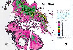
In Guam
, the threat of Typhoon Isa postponed a flight from Guam to Honolulu, Hawaii
for 48 hours. The flight was the last in Operation Pacific Haven, which was a multi-million dollar humanitarian effort to transport more than 6,600 Kurds
in a political asylum to the mainland of the United States. The threat of the typhoon also canceled the first round of the Omega Tour golf event, which was the second professional golf tournament in the island's history. Though Typhoon Isa passed well to the south of Guam, one of its outer rainbands stalled across the island, which dropped heavy rainfall of 15–25 cm (6–10 in) across the island. The rainfall was welcome as it occurred during the dry season, and largely contributed to rainfall at the Guam International Airport being 45% above normal from the period between January through April. The rainband also produced wind gusts that reached 86 km/h (53 mph) at the island's Naval Air Station
; the winds resulted in sporadic power outages across the island. The typhoon caused some light damage to buildings, particularly on the south side of the island. The combination of winds and sea salt caused damage to the island's tomato, okra, cucumber, and soy bean crops.
Typhoon Isa later dropped light rainfall on the island of Rota
. Across its path, damage from the storm totaled over $1 million (1997 USD, $1.3 million 2006 USD). No deaths or injuries were reported.
Tropical cyclone scales
Tropical systems are officially ranked on one of several tropical cyclone scales according to their maximum sustained winds and in what oceanic basin they are located...
to occur during the 1997 Pacific typhoon season
1997 Pacific typhoon season
The 1997 Pacific typhoon season has no official bounds; it ran year-round in 1997, but most tropical cyclones tend to form in the northwestern Pacific Ocean between May and November. These dates conventionally delimit the period of each year when most tropical cyclones form in the northwestern...
. The second tropical cyclone
Tropical cyclone
A tropical cyclone is a storm system characterized by a large low-pressure center and numerous thunderstorms that produce strong winds and heavy rain. Tropical cyclones strengthen when water evaporated from the ocean is released as the saturated air rises, resulting in condensation of water vapor...
of the season, Isa developed from a disturbance in the monsoon trough
Monsoon trough
The monsoon trough is that portion of the Intertropical Convergence Zone which extends into or through a monsoon circulation, as depicted by a line on a weather map showing the locations of minimum sea level pressure, and as such, is a convergence zone between the wind patterns of the southern and...
near the Caroline Islands
Caroline Islands
The Caroline Islands are a widely scattered archipelago of tiny islands in the western Pacific Ocean, to the north of New Guinea. Politically they are divided between the Federated States of Micronesia in the eastern part of the group, and Palau at the extreme western end...
on April 12. It moved erratically at first, though after attaining tropical storm status it curved westward due to the subtropical ridge
Subtropical ridge
The subtropical ridge is a significant belt of high pressure situated around the latitudes of 30°N in the Northern Hemisphere and 30°S in the Southern Hemisphere. It is characterized by mostly calm winds, which acts to reduce air quality under its axis by causing fog overnight, and haze during...
to its north. Isa very gradually intensified, and on April 20 the typhoon reached peak 1-min winds of 270 km/h (165 mph), as reported by the Joint Typhoon Warning Center
Joint Typhoon Warning Center
The Joint Typhoon Warning Center is a joint United States Navy – United States Air Force task force located at the Naval Maritime Forecast Center in Pearl Harbor, Hawaii...
; Japan Meteorological Agency
Japan Meteorological Agency
The or JMA, is the Japanese government's weather service. Charged with gathering and reporting weather data and forecasts in Japan, it is a semi-autonomous part of the Ministry of Land, Infrastructure and Transport...
reported maximum 10-min winds of 155 km/h (100 mph). After turning northward, it accelerated to the northeast, and merged with a larger extratropical cyclone
Extratropical cyclone
Extratropical cyclones, sometimes called mid-latitude cyclones or wave cyclones, are a group of cyclones defined as synoptic scale low pressure weather systems that occur in the middle latitudes of the Earth having neither tropical nor polar characteristics, and are connected with fronts and...
on April 24.
Early in its duration, Isa caused light rainfall and moderate winds on Pohnpei
Pohnpei
Not to be confused with Pompeii, the ancient city destroyed by Vesuvius in AD 79.Pohnpei "upon a stone altar " is the name of one of the four states in the Federated States of Micronesia , situated among the Senyavin Islands which are part of the larger Caroline Islands group...
. Later, a stationary rainband from the typhoon dropped heavy precipitation on Guam
Guam
Guam is an organized, unincorporated territory of the United States located in the western Pacific Ocean. It is one of five U.S. territories with an established civilian government. Guam is listed as one of 16 Non-Self-Governing Territories by the Special Committee on Decolonization of the United...
during its dry season. Damage in the Guam
Guam
Guam is an organized, unincorporated territory of the United States located in the western Pacific Ocean. It is one of five U.S. territories with an established civilian government. Guam is listed as one of 16 Non-Self-Governing Territories by the Special Committee on Decolonization of the United...
National Weather Service
National Weather Service
The National Weather Service , once known as the Weather Bureau, is one of the six scientific agencies that make up the National Oceanic and Atmospheric Administration of the United States government...
area of responsibility totaled $1 million (1997 USD, $1.3 million 2006 USD), the majority of it from crop damage. No deaths were reported.
Meteorological history
In early April, the monsoon troughMonsoon trough
The monsoon trough is that portion of the Intertropical Convergence Zone which extends into or through a monsoon circulation, as depicted by a line on a weather map showing the locations of minimum sea level pressure, and as such, is a convergence zone between the wind patterns of the southern and...
established itself across Micronesia
Micronesia
Micronesia is a subregion of Oceania, comprising thousands of small islands in the western Pacific Ocean. It is distinct from Melanesia to the south, and Polynesia to the east. The Philippines lie to the west, and Indonesia to the southwest....
near the equator
Equator
An equator is the intersection of a sphere's surface with the plane perpendicular to the sphere's axis of rotation and containing the sphere's center of mass....
. An area of convection within the trough developed in the Caroline Islands
Caroline Islands
The Caroline Islands are a widely scattered archipelago of tiny islands in the western Pacific Ocean, to the north of New Guinea. Politically they are divided between the Federated States of Micronesia in the eastern part of the group, and Palau at the extreme western end...
on April 9, and resembled the characteristics of a monsoon depression. Shortly thereafter, a large, yet weak low-level circulation formed within the system. The system drifted erratically for several days as it slowly organized; the system underwent several cycles of developing and losing convection
Convection
Convection is the movement of molecules within fluids and rheids. It cannot take place in solids, since neither bulk current flows nor significant diffusion can take place in solids....
. On April 11, the system maintained a persistent area of well-organized deep convection, and subsequent to an increase in upper-level outflow, the Joint Typhoon Warning Center
Joint Typhoon Warning Center
The Joint Typhoon Warning Center is a joint United States Navy – United States Air Force task force located at the Naval Maritime Forecast Center in Pearl Harbor, Hawaii...
(JTWC) classified the system as Tropical Depression 02W at 1800 UTC on April 11. Strong influence from the monsoonal westerlies
Westerlies
The Westerlies, anti-trades, or Prevailing Westerlies, are the prevailing winds in the middle latitudes between 30 and 60 degrees latitude, blowing from the high pressure area in the horse latitudes towards the poles. These prevailing winds blow from the west to the east, and steer extratropical...
left the depression drifting and slowly executing a loop to the northwest. Based on sufficient satellite classifications, JTWC upgraded the depression to Tropical Storm Isa early on April 12 while it was located 105 km (65 mi) of Pohnpei
Pohnpei
Not to be confused with Pompeii, the ancient city destroyed by Vesuvius in AD 79.Pohnpei "upon a stone altar " is the name of one of the four states in the Federated States of Micronesia , situated among the Senyavin Islands which are part of the larger Caroline Islands group...
. The Japan Meteorological Agency
Japan Meteorological Agency
The or JMA, is the Japanese government's weather service. Charged with gathering and reporting weather data and forecasts in Japan, it is a semi-autonomous part of the Ministry of Land, Infrastructure and Transport...
(JMA) simultaneously classified the system as a tropical depression, and upgraded it to a tropical storm early on April 13.
With the subtropical ridge
Ridge (meteorology)
A ridge is an elongated region of relatively high atmospheric pressure, the opposite of a trough....
to its north, Isa tracked to the north and gradually curved to the west. It slowly intensified, due to it being a large tropical cyclone, and late on April 13 JTWC upgraded the storm to typhoon status; at the same time, JMA continued to assess Isa as a minimal tropical storm, and did not upgrade it to a typhoon until April 16. Isa maintained a nearly due-westward movement, although tropical cyclone prediction model
Tropical cyclone prediction model
A tropical cyclone forecast model is a computer program that uses meteorological data to forecast aspects of the future state of tropical cyclones. There are three types of models: statistical, dynamical, or combined statistical-dynamic...
s anticipated a quick turn to the north. The JTWC recognized the northward model bias, which was described as under-analyzing the strength of the subtropical ridge. By April 16, the typhoon attained the equivalence of a Category 3 tropical cyclone on the Saffir-Simpson Hurricane Scale
Saffir-Simpson Hurricane Scale
The Saffir–Simpson Hurricane Scale , or the Saffir–Simpson Hurricane Wind Scale , classifies hurricanes — Western Hemisphere tropical cyclones that exceed the intensities of tropical depressions and tropical storms — into five categories distinguished by the intensities of their sustained winds...
, and despite a potential threat to Guam
Guam
Guam is an organized, unincorporated territory of the United States located in the western Pacific Ocean. It is one of five U.S. territories with an established civilian government. Guam is listed as one of 16 Non-Self-Governing Territories by the Special Committee on Decolonization of the United...
the typhoon remained 260 km (160 mi) south of the island. It gradually curved to the north, and on April 20 JTWC classified Super Typhoon Isa as reaching peak 1-min winds of 270 km/h (165 mph) while moving nearly due northward through a weakness in the subtropical ridge. Simultaneously, JMA assessed the typhoon as attaining peak 10-min winds of 155 km/h (100 mph).
Shortly after peaking in intensity, Isa began to weaken, and by April 21 it dropped below "super typhoon" status. It accelerated to the northeast under the flow of the mid-latitudes, and the typhoon weakened more rapidly; JMA downgraded Isa to a tropical storm on April 22, which was followed suit by the JTWC the next day as upper-level wind shear
Wind shear
Wind shear, sometimes referred to as windshear or wind gradient, is a difference in wind speed and direction over a relatively short distance in the atmosphere...
increased. At 0600 UTC on April 23, the JTWC issued the last advisory on the system, and the next day JMA classified Isa dissipated as it became absorbed by a cloud band from a large extratropical cyclone
Extratropical cyclone
Extratropical cyclones, sometimes called mid-latitude cyclones or wave cyclones, are a group of cyclones defined as synoptic scale low pressure weather systems that occur in the middle latitudes of the Earth having neither tropical nor polar characteristics, and are connected with fronts and...
to the east of Japan.
Impact
Pohnpei
Not to be confused with Pompeii, the ancient city destroyed by Vesuvius in AD 79.Pohnpei "upon a stone altar " is the name of one of the four states in the Federated States of Micronesia , situated among the Senyavin Islands which are part of the larger Caroline Islands group...
as a tropical storm on April 12. While passing near the island, the storm produced moderate winds across the island, peaking at 95 km/h (60 mph). The winds downed several trees and tree limbs which destroyed 40% of the island's power lines. A few buildings reported roof damage. About 15% of the crops on Pohnpei were damaged, including losses to the banana and breadfruit crops. After the passage of the typhoon, President of the Federated States of Micronesia
President of the Federated States of Micronesia
The following is a list of the Presidents of the Federated States of Micronesia:-See also:*High Commissioner of the Trust Territory of the Pacific Islands...
Jacob Nena
Jacob Nena
Jacob Nena is a Micronesian political figure who served as the fourth President of the Federated States of Micronesia from 1996 to 1999...
declared Pohnpei as a major disaster area due to the damage from Typhoon Isa and subsequent flooding; on April 20 heavy rainfall caused widespread mudslides and 19 fatalities on the island, though they were not related to Isa.
In Guam
Guam
Guam is an organized, unincorporated territory of the United States located in the western Pacific Ocean. It is one of five U.S. territories with an established civilian government. Guam is listed as one of 16 Non-Self-Governing Territories by the Special Committee on Decolonization of the United...
, the threat of Typhoon Isa postponed a flight from Guam to Honolulu, Hawaii
Honolulu, Hawaii
Honolulu is the capital and the most populous city of the U.S. state of Hawaii. Honolulu is the southernmost major U.S. city. Although the name "Honolulu" refers to the urban area on the southeastern shore of the island of Oahu, the city and county government are consolidated as the City and...
for 48 hours. The flight was the last in Operation Pacific Haven, which was a multi-million dollar humanitarian effort to transport more than 6,600 Kurds
Kurdish people
The Kurdish people, or Kurds , are an Iranian people native to the Middle East, mostly inhabiting a region known as Kurdistan, which includes adjacent parts of Iran, Iraq, Syria, and Turkey...
in a political asylum to the mainland of the United States. The threat of the typhoon also canceled the first round of the Omega Tour golf event, which was the second professional golf tournament in the island's history. Though Typhoon Isa passed well to the south of Guam, one of its outer rainbands stalled across the island, which dropped heavy rainfall of 15–25 cm (6–10 in) across the island. The rainfall was welcome as it occurred during the dry season, and largely contributed to rainfall at the Guam International Airport being 45% above normal from the period between January through April. The rainband also produced wind gusts that reached 86 km/h (53 mph) at the island's Naval Air Station
Naval Air Station
A Naval Air Station is a military airbase, and consists of a permanent land-based operations locations for the military aviation division of the relevant branch of their Navy...
; the winds resulted in sporadic power outages across the island. The typhoon caused some light damage to buildings, particularly on the south side of the island. The combination of winds and sea salt caused damage to the island's tomato, okra, cucumber, and soy bean crops.
Typhoon Isa later dropped light rainfall on the island of Rota
Rota (island)
Rota also known as the "peaceful island", is the southernmost island of the United States Commonwealth of the Northern Mariana Islands and the second southernmost of the Marianas Archipelago. It lies approximately 40 miles north-northeast of the United States territory of Guam...
. Across its path, damage from the storm totaled over $1 million (1997 USD, $1.3 million 2006 USD). No deaths or injuries were reported.