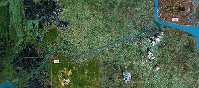
Twante Canal
Encyclopedia

Canal
Canals are man-made channels for water. There are two types of canal:#Waterways: navigable transportation canals used for carrying ships and boats shipping goods and conveying people, further subdivided into two kinds:...
that connects the Irrawaddy River and the Yangon river
Yangon River
The Yangon River is formed by the confluence of the Pegu and Myitmaka rivers and is a marine estuary that runs from Yangon emptying into the Gulf of Martaban of the Andaman Sea...
in Myanmar
Myanmar
Burma , officially the Republic of the Union of Myanmar , is a country in Southeast Asia. Burma is bordered by China on the northeast, Laos on the east, Thailand on the southeast, Bangladesh on the west, India on the northwest, the Bay of Bengal to the southwest, and the Andaman Sea on the south....
. The 35 km (21.7 mi) canal is a heavily used short cut between the city of Yangon
Yangon
Yangon is a former capital of Burma and the capital of Yangon Region . Although the military government has officially relocated the capital to Naypyidaw since March 2006, Yangon, with a population of over four million, continues to be the country's largest city and the most important commercial...
and the Irrawaddy Division. The canal is named after the town of Twante, located near the canal's mid-way point. The canal was the quickest route from Yangon to the Irrawaddy Delta
Irrawaddy Delta
The Irrawaddy Delta or Ayeyarwady Delta lies in the Ayeyarwady Region , the lowest expanse of land in Burma that fans out from the limit of tidal influence at Myan Aung to the Bay of Bengal and Andaman Sea, 290 km to the south at the mouth of the Ayeyarwady River...
until the 1990s when roads between Yangon and the Irrawaddy Division became usable year round. The canal is still heavily used.
Due to the lack of regular maintenance, the canal has become silted and narrower over the years. In 2010, the mouth of the canal was widened by 600 feet. However, plans to put in concrete embankments were yet to be carried out, and the navigation problems still remain.

