

Turner, Kansas
Encyclopedia
Community
The term community has two distinct meanings:*a group of interacting people, possibly living in close proximity, and often refers to a group that shares some common values, and is attributed with social cohesion within a shared geographical location, generally in social units larger than a household...
in the southwestern corner of Wyandotte County
Wyandotte County, Kansas
Wyandotte County is a county located in northeast Kansas, in the Central United States. The county's population was 157,505 for the 2010 census. Its county seat and most populous city is Kansas City with which it shares a unified government...
, Kansas
Kansas
Kansas is a US state located in the Midwestern United States. It is named after the Kansas River which flows through it, which in turn was named after the Kansa Native American tribe, which inhabited the area. The tribe's name is often said to mean "people of the wind" or "people of the south...
, United States
United States
The United States of America is a federal constitutional republic comprising fifty states and a federal district...
. It is the youngest community in the County.
History
The ProphetTenskwatawa
Tenskwatawa, was a Native American religious and political leader of the Shawnee tribe, known as The Prophet or the Shawnee Prophet. He was the brother of Tecumseh, leader of the Shawnee...
(Tenskwatawa; literally, "the door opener"), brother of Tecumseh
Tecumseh
Tecumseh was a Native American leader of the Shawnee and a large tribal confederacy which opposed the United States during Tecumseh's War and the War of 1812...
, created Shawneetown in the area (near what today is Woodend and Shawnee Drive at 35th street). He made his final home near Turner in Argentine, Kansas
Argentine, Kansas
Argentine is a community of Kansas City, Kansas, located in the southern part of Wyandotte County. It is bordered on the west by the Turner community, on the east by the Rosedale community, on the south by Johnson County, and on the north by Armourdale community and by the Kansas River. Argentine...
(the property is today owned by Jack Beemont). Blue Jacket
Blue Jacket
Blue Jacket or Weyapiersenwah was a war chief of the Shawnee people, known for his militant defense of Shawnee lands in the Ohio Country...
(Weyapiersenwah), who was Tecumseh's adoptive brother, was known to the early European settlers in this area. According to legend, one of the Shawnee chiefs, Fish, died and was buried in the Shawnee Township Cemetery (which is located in the heart of modern day Turner).
19th century
In 1828, Cyprian Chouteau established the first trading post in this locale. It was the American Fur Company trading house (located near 55th and Speaker Road). The original Shawnee Methodist MissionShawnee Methodist Mission
Shawnee Methodist Mission was a camp established by missionaries in 1830 to minister to the Shawnee tribe of Native Americans, relocated to its present location in 1839. It was also the second capital of the Kansas Territory, holding that designation from July 16, 1855, to the spring of 1856...
was built in 1830 near Chouteau's old trading post (near the heart of the Turner community). Reverend Thomas Johnson
Thomas Johnson (Kansas)
Thomas Johnson was a Methodist missionary and a member of the Kansas territorial legislature. He was robbed and murdered in 1865. Johnson County, Kansas is named for him...
built the mission for the Shawnee. It was located at what would be 5100 block of Edgehill Drive. This mission was open till until 1839, when the Mission School was built at the current location in Johnson County. Around 1837, Charles Lovelace established a saw mill (today it would be located at 55th and Speaker Road, but has been long ago torn down). There was also a grist mill in close proximity. In 1838, the mighty steamboat, "The Antelope
The Antelope
In 1825 The Antelope, a Spanish slave ship, was captured by a privateer and other Africans bound for the slave trade were put on board the ship...
" docked in the area. It had several scientist and pioneers heading west. They stayed over in the area on their journey to Fort Pierre in South Dakota
South Dakota
South Dakota is a state located in the Midwestern region of the United States. It is named after the Lakota and Dakota Sioux American Indian tribes. Once a part of Dakota Territory, South Dakota became a state on November 2, 1889. The state has an area of and an estimated population of just over...
.
The Delaware Crossing
Grinter Place
Grinter Place is a house on the National Register of Historic Places above the Kansas River in the Muncie neighborhood of Kansas City, Kansas.The house was constructed by Moses Grinter where he and his half-Lenape wife lived until he died in 1878 and she in 1905...
(or "Military Crossing"; sometimes "the Secondine") was where the old Indian trail
Indian Trail
Indian Trail can refer to:*A part of or the whole of the Great Trail created by Native Americans*Indian Trail, North Carolina*A junior high in Olathe, Kansas -- Indian Trail Junior High...
met the water's of the Kaw River. Around 1831, Moses Grinter (one of the earliest permanent white settler in the area) set up the Grinter Ferry on the Kansas River
Kansas River
The Kansas River is a river in northeastern Kansas in the United States. It is the southwestern-most part of the Missouri River drainage, which is in turn the northwestern-most portion of the extensive Mississippi River drainage. Its name come from the Kanza people who once inhabited the area...
here. His house, the Grinter Place
Grinter Place
Grinter Place is a house on the National Register of Historic Places above the Kansas River in the Muncie neighborhood of Kansas City, Kansas.The house was constructed by Moses Grinter where he and his half-Lenape wife lived until he died in 1878 and she in 1905...
, still stands at 1420 South 78th Street. The ferry was used by individuals (such as traders, freighters, and soldiers) traveling between Fort Leavenworth
Fort Leavenworth
Fort Leavenworth is a United States Army facility located in Leavenworth County, Kansas, immediately north of the city of Leavenworth in the upper northeast portion of the state. It is the oldest active United States Army post west of Washington, D.C. and has been in operation for over 180 years...
and Fort Scott
Fort Scott, Kansas
Fort Scott is a city in and the county seat of Bourbon County, Kansas, United States, south of Kansas City, on the Marmaton River. As of the 2010 census, the city population was 8,087. It is the home of the Fort Scott National Historic Site and the Fort Scott National...
on the military road. Other would cross this area on their way to Santa Fe.
Various farmers took up residence around Turner by the fall of 1854. Turner as a community was known as early as 1856 (and no later than 1859). The community, then named "Farmer, Kansas", tried to incorporate itself on October 8, 1859. The attempt failed because the community never had enough population to achieve the statute requirements.
Members of the old Quantrill's Raiders
Quantrill's Raiders
Quantrill's Raiders were a loosely organized force of pro-Confederate Partisan rangers, "bushwhackers", who fought in the American Civil War under the leadership of William Clarke Quantrill...
sacked a few homes and killed some of the inhabitants of the area around July 1863. Various families (living in the area that today is between Swartz Road from 51st to 53rd Street) suffered in the attacks. They were fended off from but a few homes.
In 1859, the community had been referred to as the "Farmer" community (when the first post office was established). Twenty years later, the community took the name "Turner". Farmer post office name was switched to the "Turner" post office on September 23, 1879; by Robert M. Hester. Jeanie Turner, states that her father was an engineer who laid out the roads of the newly formed town and it was named in his honor. Article in the Wyandot Herald, May 22, 1879 says Turner is the youngest town in the County. [Annotation: Farmer was a post office until September 23, 1879, when Robert M. Hester changed the name to Turner.]
20th century
The Flood of 1903 hit Turner. The 1910 population was around 200 people. In 1912, Turner had a few general stores, a school, money order post office, telegraph and express facilities.Historically, the Atchison, Topeka and Santa Fe Railway
Atchison, Topeka and Santa Fe Railway
The Atchison, Topeka and Santa Fe Railway , often abbreviated as Santa Fe, was one of the larger railroads in the United States. The company was first chartered in February 1859...
went through Argentine, Turner, and Kaw Valley. From the railroad yard in the Argentine, the railroad cars would be turned around at the Farmer train platform. The Farmer train station's circular platform stood at 55th street (which is Turner’s main downtown area).
Parts of Turner were hit in the Great Flood of 1951
Great Flood of 1951
In mid-July 1951, heavy rains led to a great rise of water in the Kansas River and other surrounding areas. Flooding resulted in the Kansas, Neosho, Marais Des Cygnes, and Verdigris river basins. The damage in June and July 1951 exceeded $935 million dollars in an area covering eastern Kansas and...
and the flood resulted in the "Highland" community being built (for displaced individuals from Argentine and Armourdale). Between late 1965 and early 1966, Kansas City, Kansas annexed the community of Turner. Although now a part of Kansas City, Kansas,the community still retains its own distinct flavor and personality.
Primary and secondary education
Golden Bear
According to legend, the Golden Bear was a large golden Ursus arctos. Members of the Ursus arctos species can reach masses of . The Grizzly Bear and the Kodiak Bear are North American subspecies of the Brown Bear....
mascot
Mascot
The term mascot – defined as a term for any person, animal, or object thought to bring luck – colloquially includes anything used to represent a group with a common public identity, such as a school, professional sports team, society, military unit, or brand name...
was adopted for the school and community in 1886. Two members of the community, Warren Hewitt and Jule Gaignet, submitted the icon and it won the majority of support in a contest. Reportedly, the two youths had heard of the bear from stories told by their grandparents. This icon is based on legends of a golden bear that live in the area.
According to John Gardiner in 1831, the great golden bear that lived in the area was feared and admired by the local native population. The bear lived south of the river in the hills west of the Methodist Mission. According to legend, it was the largest bear that any of the natives had ever seen. It would raid the settlements of the area folks and feasted on the animals owned by the local population (the Shawnee tribe). Many of the Indians wanted to kill the bear for the pride of such a feat and the capture of its hide (the fur was most sought after). The golden bear was seen several times by the ferry crew on the Old Grinter Ferry during the 1830s and 1840s. Both the Shawnee and the Wyandot gathered a hunting party, but were unsuccessful in tracking the bear down.
Turner USD 202 consists of:
Street names
The road overseers were Peter Partonnar, John Gibbs, and H. L. Swinggley. Peter Partonnar (sometimes misspelled as Parturner) has been rumored to be the origin of the name for Turner (but this is doubtful as the Partonnar family lived in Shawnee for many years and did not come to live in Turner till the name was already acquired).New and old
External links
- Turner, Kansas. placeopedia.com.
- Grinter Place: Kansas State Historical Society Properties
- Wyandotte County, Kansas Cemeteries; Includes the Shawnee Township / Turner burial grounds (Located at South 55th & Edgehill Street almost across from the old Turner High School; It contains about 30 gravesites)
- The History of the Public Schools of Wyandotte County, Kansas
- River @ Turner bridge, crh.noaa.gov.
- Turner, Kansas maps.google.com
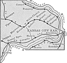
- Old Wyandotte map. skyways.lib.ks.us
- "Centennial History of Argentine", Kansas City, Kansas 1880-1980. Information on John Gibbs, Jr.
- The History of Kansas City, Kansas in pamphlet series; Series 1: "OLD WYANDOTTE"
- Charles Lovelace, skyways.lib.ks.us.