
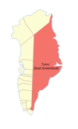
Tunu
Encyclopedia

Greenland
Greenland is an autonomous country within the Kingdom of Denmark, located between the Arctic and Atlantic Oceans, east of the Canadian Arctic Archipelago. Though physiographically a part of the continent of North America, Greenland has been politically and culturally associated with Europe for...
, until 31 December 2008. The county seat
County seat
A county seat is an administrative center, or seat of government, for a county or civil parish. The term is primarily used in the United States....
was at the main settlement, Tasiilaq
Tasiilaq
Tasiilaq is a town in the Sermersooq municipality in southeastern Greenland. With 1,930 inhabitants as of 2010, it is the most populous community on the eastern coast, and the seventh-largest town in Greenland...
. Population in 2005 was around 3,800.
The county was made up of two former municipalities, Ammassalik Municipality and Illoqqortoormiut, while part of the Northeast Greenland National Park
Northeast Greenland National Park
Northeast Greenland National Park is the largest national park in the world, with an area of , making the park larger than 163 countries. It is the only national park in Greenland, and the most northerly national park in the world, its most northerly point reaching slightly further than the most...
covered the northern half of the county.
It was bordered in the east by the Greenland Sea
Greenland Sea
The Greenland Sea is a body of water that borders Greenland to the west, the Svalbard archipelago to the east, Fram Strait and the Arctic Ocean to the north, and the Norwegian Sea and Iceland to the south. The Greenland Sea is often defined as part of the Arctic Ocean, sometimes as part of the...
, Norwegian Sea
Norwegian Sea
The Norwegian Sea is a marginal sea in the North Atlantic Ocean, northwest of Norway. It is located between the North Sea and the Greenland Sea and adjoins the North Atlantic Ocean to the west and the Barents Sea to the northeast. In the southwest, it is separated from the Atlantic Ocean by a...
, Denmark Strait
Denmark Strait
The Denmark Strait or Greenland Strait |Sound]]) is an oceanic strait between Greenland and Iceland...
and the North Atlantic Ocean. To the west lies Kitaa
Kitaa
Kitaa/Vestgrønland was the most populous of the three counties of Greenland, being home to almost 90% of the total population. The county seat was the Greenlandic capital, Nuuk....
.
See also
- Subdivisions of Norden
- Administrative divisions of Greenland
- Erik the Red's LandErik the Red's LandErik the Red's Land was the name given by Norwegians to an area on the coast of eastern Greenland occupied by Norway in the early 1930s. It was named after Erik the Red, the founder of the first Norse settlements in Greenland in the 10th century...
- East Greenland CurrentEast Greenland CurrentThe East Greenland Current is a cold, low salinity current that extends from Fram Strait to Cape Farewell . The current is located off the eastern coast of Greenland along the Greenland continental margin. The current cuts through the Nordic Seas and through the Denmark Strait...
- Eastern SettlementEastern SettlementThe Eastern Settlement was the largest and first of the three areas of Greenland, settled in approximately 985 AD by Norse farmers from Iceland . At its peak it contained approximately 4,000 inhabitants...