

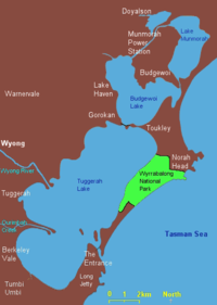
Tuggerah Lake
Encyclopedia
New South Wales
New South Wales is a state of :Australia, located in the east of the country. It is bordered by Queensland, Victoria and South Australia to the north, south and west respectively. To the east, the state is bordered by the Tasman Sea, which forms part of the Pacific Ocean. New South Wales...
about 90 kilometres (55.9 mi) north of Sydney
Sydney
Sydney is the most populous city in Australia and the state capital of New South Wales. Sydney is located on Australia's south-east coast of the Tasman Sea. As of June 2010, the greater metropolitan area had an approximate population of 4.6 million people...
. It is connected with the sea through a tidal channel at its southern end known as The Entrance
The Entrance, New South Wales
The Entrance is a district centre and town of the Central Coast region of New South Wales, Australia. It is part of the Wyong Shire local government area. At the 2006 census, The Entrance had a population of 2,632 people....
. It is also connected with two smaller lakes, Budgewoi Lake and through that to Lake Munmorah
Lake Munmorah
Lake Munmorah may refer to:*Lake Munmorah, New South Wales - A suburb on the Central Coast of New South Wales, Australia*Lake Munmorah - The northern most lake of the body of water collectively known as The Tuggerah Lakes...
. It adjoins extensive areas of suburban development.
Description
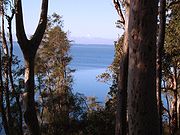
Tuggerah Lake is generally quite shallow with an average depth around 2.5 metres. The Wyong River, Ourimbah Creek and Tumbi Creek empty into the southern half of Tuggerah Lake and because of this after heavy rains in June 2007 the lake flooded affecting areas of Long Jetty, Killarney Vale and Chittaway Point. On the sea side of the peninsula is Norah HeadNorah Head, New South Wales
Norah Head, originally known as Bungaree Noragh Point, is a headland on the Central Coast, New South Wales, Australia, south of Newcastle and north of Sydney. The nearest town is Toukley. The place is home to a lighthouse with scenic views, which is also considered a venue for weddings...
and its historic lighthouse
Lighthouse
A lighthouse is a tower, building, or other type of structure designed to emit light from a system of lamps and lenses or, in older times, from a fire, and used as an aid to navigation for maritime pilots at sea or on inland waterways....
.
Urban areas
Many towns surround the lake including, but not limited to, Lake Munmorah
Lake Munmorah, New South Wales
Lake Munmorah is a suburb of the Central Coast region of New South Wales, Australia. It is part of the Wyong Shire local government area. Steve Bisley from the Australian police drama, Water Rats, grew up in Lake Munmorah....
The Entrance
The Entrance, New South Wales
The Entrance is a district centre and town of the Central Coast region of New South Wales, Australia. It is part of the Wyong Shire local government area. At the 2006 census, The Entrance had a population of 2,632 people....
, Killarney Vale
Killarney Vale, New South Wales
Killarney Vale is a suburb of the Central Coast region of New South Wales, Australia, located northwest of Bateau Bay. It is part of the Wyong Shire local government area....
, Berkeley Vale
Berkeley Vale, New South Wales
Berkeley Vale is a suburb of the Central Coast region of New South Wales, Australia. It is part of the Wyong Shire local government area.Wyong Road is the main road that runs through Berkeley Vale...
, Tumbi Umbi
Tumbi Umbi, New South Wales
Tumbi Umbi is a mostly semi-rural suburb of the Central Coast region of New South Wales, Australia, located northwest of Bateau Bay. It is part of the Wyong Shire local government area....
, Wyong
Wyong, New South Wales
Wyong was proclaimed a town in 1888 and is currently a major northern suburb of the Central Coast region of New South Wales, located approximately 89 km NNE of Sydney. It is the administrative centre for the Wyong Shire local government area.- History :...
, Kanwal
Kanwal, New South Wales
Kanwal is a suburb of the Central Coast region of New South Wales, Australia. It is part of the Wyong Shire local government area.It is approximately 90 km north of Sydney, 55km south of Newcastle and 6 km west of the Pacific Ocean.-History:...
, Gorokan
Gorokan, New South Wales
Gorokan is a suburb of the Central Coast region of New South Wales, Australia. It is part of the Wyong Shire local government area. There are two schools in the area, Gorokan Public and Gorokan High. In 1985, Gorokan Public had a champion cricket team which made the quarter-finals of the Statewide...
and Toukley
Toukley, New South Wales
Toukley is a town in the Central Coast region of the Australian state of New South Wales. It lies approximately 107 km north of Sydney via the F3 freeway. It is located between Tuggerah Lake, Budgewoi Lake, and the Pacific Ocean. The town is within the area of the Wyong Shire...
.
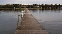
South of The Entrance is Long Jetty
Long Jetty, New South Wales
Long Jetty is a suburb of the Central Coast region of New South Wales, Australia, located on a peninsula between Tuggerah Lake and the Pacific Ocean south of The Entrance. It is part of the Wyong Shire local government area.- Transportation :...
, so named for the jetty built to service the first sub-division of land at The Entrance. The original jetty was washed away in a flood at Easter 1927; the present structure replaced it, built in 1927–28 to a length of 1152 feet (351 m). Parts of the jetty have fallen into disrepair and it requires frequent periodic repairs and replacement of its structure and decking.
Fishing and boating
Tuggerah Lake is well known for its recreational fishing with species such as luderick, bream, flathead and whitingWhiting
Whiting is the name of several species of fish:*Merlangius merlangus, the original species to receive the name; a common food fish of the cod family found in the northeastern Atlantic Ocean around Europe and the Mediterranean regions...
caught from the shoreline and boats. Prawns can be plentiful over the summer months during the dark of the new moon. Fishing in Tuggerah Lake is generally poor during late winter and early spring, particularly when westerly winds are prevalent.
Special purpose markers (coloured yellow) around Terilbah Island and Pelican Island denote areas where net and trap fishing are restricted. Other parts of the lake may have permanent or temporary fishing restrictions in force and the exact details are specified here: NSW DPI Tuggerah Lakes Restrictions
Due to its large size and shallow depth strong winds can whip up a steep choppy surface that can be hazardous to small boats, however Tuggerah Lake is considered quite safe for most forms of small recreational watercraft if common sense and general safe boating practices are followed. It should be noted many parts of Tuggerah Lake are quite shallow with sand or weed flats exposed at low water. Marked channels should be navigated with care and at reduced speed. Mobile phone coverage is available across the entire lake.
Environment
Substantial residential and commercial development, involving excavation and alteration of native vegetation and natural watercourses in the lake catchment and hinterland, has given rise to siltation and changes in the make up of the lakebed and foreshore. During 2004 and 2005 the Tuggerah Lakes Restoration project has been attempting to restore and revive the lake system. Urbanisation and development have caused increased nutrients to build up in the lake stimulating weed growth. Restoration work has focussed on inshore removal of weed and ooze; foreshore reclamation and reinstatement; pollutant traps; and channel dredging to increase the tidal exchange of water with the sea.Wyrrabalong National Park
Wyrrabalong National Park
Wyrrabalong National Park is located on the Central Coast of New South Wales, Australia. It was added in 1991. The park consists of two main sections. The northern section consists of approximately 480 hectares and covers a substantial area of the peninsula between The Entrance and Norah Head as...
borders the lake and the sea separating the residential areas of Toukley
Toukley, New South Wales
Toukley is a town in the Central Coast region of the Australian state of New South Wales. It lies approximately 107 km north of Sydney via the F3 freeway. It is located between Tuggerah Lake, Budgewoi Lake, and the Pacific Ocean. The town is within the area of the Wyong Shire...
and The Entrance, and preserves the last significant littoral rainforest on the Central Coast. The lake is part of the Tuggerah Important Bird Area
Important Bird Area
An Important Bird Area is an area recognized as being globally important habitat for the conservation of bird populations. Currently there are about 10,000 IBAs worldwide. The program was developed and sites are identified by BirdLife International...
, identified as such by BirdLife International
BirdLife International
BirdLife International is a global Partnership of conservation organisations that strives to conserve birds, their habitats and global biodiversity, working with people towards sustainability in the use of natural resources...
because of its importance for a variety of water and woodland
Woodland
Ecologically, a woodland is a low-density forest forming open habitats with plenty of sunlight and limited shade. Woodlands may support an understory of shrubs and herbaceous plants including grasses. Woodland may form a transition to shrubland under drier conditions or during early stages of...
birds.