

Tsauchab
Encyclopedia
Namibia
Namibia, officially the Republic of Namibia , is a country in southern Africa whose western border is the Atlantic Ocean. It shares land borders with Angola and Zambia to the north, Botswana to the east and South Africa to the south and east. It gained independence from South Africa on 21 March...
, in the southern Naukluft Mountains
Naukluft Mountains
thumb|222 px|Naukluft, seen from Sesriem The Naukluft Mountains are a massif in central Namibia, forming the easternmost part of the Namib-Naukluft National Park. They are known for their wildlife, including mountain zebras and leopards...
. It is approximately 100 km (62.1 mi) long, and known especially for the portion in which it flows through the Sesriem Canyon.
Since it is in the Namib Desert
Namib Desert
The Namib Desert is a desert in Namibia and southwest Angola that forms part of the Namib-Naukluft National Park, the largest game reserve in Africa. The name "Namib" is of Nama origin and means "vast place"...
, the Tsauchab carries water only during the rare times when rain falls in the Naukluft Mountains
Naukluft Mountains
thumb|222 px|Naukluft, seen from Sesriem The Naukluft Mountains are a massif in central Namibia, forming the easternmost part of the Namib-Naukluft National Park. They are known for their wildlife, including mountain zebras and leopards...
and runs off, since it cannot seep into the soil fast enough (see flash flood
Flash flood
A flash flood is a rapid flooding of geomorphic low-lying areas—washes, rivers, dry lakes and basins. It may be caused by heavy rain associated with a storm, hurricane, or tropical storm or meltwater from ice or snow flowing over ice sheets or snowfields...
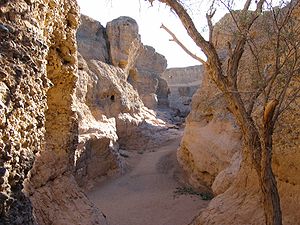
). During these rains, the Tsauchab becomes a rapid-running, strong river within a matter of hours. As a result of the occasional rains, it has over the past two million years carved the Sesriem Canyon, a kilometer (0.6 mile) long and up to 30-meter (100-foot) deep canyon
Canyon
A canyon or gorge is a deep ravine between cliffs often carved from the landscape by a river. Rivers have a natural tendency to reach a baseline elevation, which is the same elevation as the body of water it will eventually drain into. This forms a canyon. Most canyons were formed by a process of...
in sedimentary rock
Sedimentary rock
Sedimentary rock are types of rock that are formed by the deposition of material at the Earth's surface and within bodies of water. Sedimentation is the collective name for processes that cause mineral and/or organic particles to settle and accumulate or minerals to precipitate from a solution....
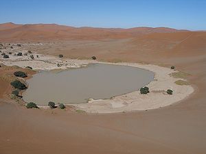
. Past the canyon, the Tsauchab flattens and grows broader, and is surrounded by a riparian forest
Riparian forest
A riparian forest is a forested area of land adjacent to a body of water such as a river, stream, pond, lake, marshland, estuary, canal, sink or reservoir. -Etymology:...
as it slopes towards the Sossusvlei
Sossusvlei
Sossusvlei is a salt and clay pan surrounded by high red dunes, located in the southern part of the Namib Desert, in the Namib-Naukluft National Park of Namibia...
salt pan
Salt pan (geology)
Natural salt pans are flat expanses of ground covered with salt and other minerals, usually shining white under the sun. They are found in deserts, and should not be confused with salt evaporation ponds.A salt pan is formed where water pools...
.
External links
- Tsauchab River and Sossus Vlei Lakebed, Namibia at the NASA Earth ObservatoryNASA Earth ObservatoryNASA Earth Observatory is an online publishing outlet for NASA which was created in 1999. It is the principal source of satellite imagery and other scientific information pertaining to the climate and the environment which are being provided by NASA for consumption by the general public...
website