

Tröllaskagi
Encyclopedia
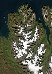
Peninsula
A peninsula is a piece of land that is bordered by water on three sides but connected to mainland. In many Germanic and Celtic languages and also in Baltic, Slavic and Hungarian, peninsulas are called "half-islands"....
in northern Iceland
Iceland
Iceland , described as the Republic of Iceland, is a Nordic and European island country in the North Atlantic Ocean, on the Mid-Atlantic Ridge. Iceland also refers to the main island of the country, which contains almost all the population and almost all the land area. The country has a population...
between the fjord
Fjord
Geologically, a fjord is a long, narrow inlet with steep sides or cliffs, created in a valley carved by glacial activity.-Formation:A fjord is formed when a glacier cuts a U-shaped valley by abrasion of the surrounding bedrock. Glacial melting is accompanied by rebound of Earth's crust as the ice...
s of Eyjafjörður
Eyjafjörður
Eyjafjörður is the longest fjord in central northern Iceland. It is located in the second most populous region of Iceland.-Physical geography:...
and Skagafjörður
Skagafjörður
Skagafjörður is a deep bay in northern Iceland.-Location:Skagafjörður is about 40 km long and 15 km wide, situated between Tröllaskagi to the west and the Tjornes Peninsula to the east. There are two municipalities in the area, Skagafjörður Municipality and Akrahreppur Municipality Skagafjörður...
. The peninsula is mountain
Mountain
Image:Himalaya_annotated.jpg|thumb|right|The Himalayan mountain range with Mount Everestrect 58 14 160 49 Chomo Lonzorect 200 28 335 52 Makalurect 378 24 566 45 Mount Everestrect 188 581 920 656 Tibetan Plateaurect 250 406 340 427 Rong River...
ous with several peaks reaching over 1000 meters above sea level, the tallest is Kerling
Kerling (Iceland)
Mt Kerling is the highest mountain in the District of Eyjafjarðarsveit, in the northern part of Iceland.Its structure is mainly basaltic rock, but the uppermost part is rhyolite, which extends to Mts Súlur nearby and all the way to the lower slopes of Mt...
(1538 m). It is the part of Iceland with the highest elevation outside the central highlands
Highlands of Iceland
The Highlands of Iceland cover most of the interior of Iceland. They are situated above 400–500 metres and are mostly an uninhabitable volcanic desert, because the water precipitating as rain or snow infiltrates so quickly into the ground that it is unavailable for plant growth, which results...
.
The peninsula is cut by several deep valley
Valley
In geology, a valley or dale is a depression with predominant extent in one direction. A very deep river valley may be called a canyon or gorge.The terms U-shaped and V-shaped are descriptive terms of geography to characterize the form of valleys...
s that were carved by glaciers during the glacial period
Glacial period
A glacial period is an interval of time within an ice age that is marked by colder temperatures and glacier advances. Interglacials, on the other hand, are periods of warmer climate within an ice age...
s of the last Ice age
Ice age
An ice age or, more precisely, glacial age, is a generic geological period of long-term reduction in the temperature of the Earth's surface and atmosphere, resulting in the presence or expansion of continental ice sheets, polar ice sheets and alpine glaciers...
and later by the river
River
A river is a natural watercourse, usually freshwater, flowing towards an ocean, a lake, a sea, or another river. In a few cases, a river simply flows into the ground or dries up completely before reaching another body of water. Small rivers may also be called by several other names, including...
s that now flow down those valleys. A few permanent glacier ice caps still exist in central Tröllaskagi but they are all rather small.
Human settlement is only extant in the relatively flat lowlands along the coast and in the valleys but these lowlands are densely populated by Icelandic standards with important agricultural
Agriculture
Agriculture is the cultivation of animals, plants, fungi and other life forms for food, fiber, and other products used to sustain life. Agriculture was the key implement in the rise of sedentary human civilization, whereby farming of domesticated species created food surpluses that nurtured the...
regions and a few towns and villages that mostly base their livelihood on fisheries. Those settlements are (clockwise around the peninsula beginning in Skagafjörður): Hofsós
Hofsós
Hofsós is one of the oldest trading ports in northern Iceland dating back to the 16th century.Hofsós, with a population of about 200 individuals, is located 37 km east from Sauðárkrókur....
, Hólar
Hólar
Hólar is a small community located in the Skagafjörður district and situated in northern Iceland.-Location:Hólar is located in the Hjaltadalur valley, some from the national capital at Reykjavík. Hólar has a population of around 100...
, Siglufjörður
Siglufjörður
Siglufjörður is a small fishing town in a narrow fjord with the same name on the northern coast of Iceland.Population in January 2011 was 1,206 but the town has been shrinking in size since the 1950s when the town reached its peak with 3,000 inhabitants....
, Ólafsfjörður
Ólafsfjörður
Ólafsfjörður is a town in the northeast of Iceland located at the mouth of the fjord Eyjafjörður.The town is connected to Eyjafjordur via a 3.5 km one-lane tunnel...
, Dalvík
Dalvík
Dalvíkurbyggð is a municipality in the north of Iceland.The population of the municipality is about 2,000- History :The municipality of Dalvíkurbyggð was formed in 1998 by the merger of three districts of outer Eyjafjörður: the town of Dalvík and the rural districts of Svarfaðardalur and Árskógur...
, Árskógssandur, Hauganes
Hauganes
Hauganes is a small village in Iceland located 30 km north of Akureyri.Hauganes is located in Eyjafjörður, the longest fjord in central northern Iceland. Hauganes has about 137 inhabitants....
, Hjalteyri
Hjalteyri
Hjalteyri is a town in northern Iceland in the Norðurland eystra region.Hjalteyri has 43 inhabitants and was the largest settlement in the former municipality of Arnarneshreppur before it merged to become part of Hörgársveit. Hjalteyri is on the west bank of the Eyjafjörður fjord and is one of the...
, Hrafnagil and the largest being Akureyri
Akureyri
Akureyri is a town in northern Iceland. It is Iceland's second largest urban area and fourth largest municipality ....
.
Öxnadalsheiði
The Ring RoadRoute 1 (Iceland)
Route 1 or the Ring Road is a main road in Iceland that runs around the island and connects all habitable parts of the country . The total length of the road is ....
runs through Tröllaskagi between Siglufjörður and Eyjafjörður through a mountain pass called Öxnadalsheiði where the road reaches a maximum elevation of 540 meters above sea level which can sometimes pose a problem during wintertime. Several different tunnel
Tunnel
A tunnel is an underground passageway, completely enclosed except for openings for egress, commonly at each end.A tunnel may be for foot or vehicular road traffic, for rail traffic, or for a canal. Some tunnels are aqueducts to supply water for consumption or for hydroelectric stations or are sewers...
ing projects have been suggested as a way to bypass Öxnadalsheiði.