
.gif)
Tropical Storm Arthur (1996)
Encyclopedia
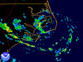
Tropical Storm Arthur caused minimal flooding in the Carolinas
in mid-June 1996. The first tropical cyclone and named storm of the annual Atlantic hurricane season, Arthur originated from an area of increased convection
east of the Bahamas on June 16. Gradually, the system increased in organization, and was designated as a tropical depression on June 17. The depression tracked north-northwest and became Tropical Storm Arthur while just offshore the Southeastern United States
on June 19. Later that day, Arthur peaked with maximum sustained wind
s of 45 mph (75 km/h), but weakened slightly before making landfall
in North Carolina
early the following day. After striking North Carolina, Arthur tracked out to sea and weakened further to a tropical depression. By June 21, Arthur transitioned into an extratropical cyclone
. Overall, impact from Arthur was minimal, limited to light rainfall and moderate surf in North and South Carolina
, as well as a tornado in Florida. Total damage amounted to $1 million (1996 USD), but no fatalities were reported.
east of the Bahamas, which was believed to have been associated with a tropical wave
. On June 17, the convection increased in organization at the lower levels of the atmosphere. By 1800 UTC, the system had organized sufficiently to be designated as a tropical depression, making it the first of the season. Initially, the depression tracked north-northwest under the steering currents of the low-level flow around the western periphery of the Atlantic subtropical ridge
. Strong wind shear
due to fast upper-level winds associated with a cold-core low
over the eastern Gulf of Mexico hindered further intensification for a time, but on June 18, an area of deep convection developed north of the center of circulation. Based on analysis of reconnaissance data, the tropical depression was upgraded to Tropical Storm Arthur at 1900 UTC on June 19.
Further strengthening occurred, as the storm attained peak winds of 45 mph (75 km/h). With time, Arthur gradually turned northeast and made landfall near Cape Lookout, North Carolina early on June 20. The center moved over the Pamlico Sound
and the Cape Hatteras National Seashore and exited into the Atlantic. Although the storm contained minimal deep convection, satellite imagery indicated that Arthur had a well-defined low-level center. The tropical storm weakened to a tropical depression about 100 mi (160.9 km) northeast of Cape Hatteras, and accelerated towards the northeast when westerly steering currents increased. Deep convection increased once again on June 21, although the lack of symmetry indicated that the remnants of Arthur were losing tropical characteristics. Forward speed increased to 40 mph (64.4 km/h) and the storm subsequently lost all tropical characteristics at 1200 UTC on June 21, while centered about 350 mi (563.3 km) north-northeast of Bermuda. The extratropical
remnants tracked northeastward for 36 hours, and were last identified about midway between Newfoundland and the Azores
, where it was absorbed by a much larger extratropical cyclone over the North Atlantic.
 On June 18, a tropical storm warning was issued for coastal locations from Edisto Beach, South Carolina
to Cape Lookout, North Carolina. Shortly thereafter, a tropical storm watch was issued north of Cape Lookout to the North Carolina
/Virginia
border, including Pamlico and Albemarle Sound
s. The tropical storm watch was later extended from the North Carolina/Virginia border to Cape Charles, Virginia
, including Virginia Beach. By late on June 19, all advisories were discontinued.
One tornado touched down in Florida, causing no known fatalities or injuries. As the center of Arthur passed 75 mi (120.7 km) east of Cape Romain, South Carolina, minor increases in surf were reported. In North Carolina, swells ranged as high as 7 ft (2.1 m). Rainfall peaked at 5.85 inches (148.6 mm) in Georgetown, South Carolina
, though because it fell gradually, no significant flooding was reported, other than minor ponding of water on roads. In addition, Arthur also brought precipitation to Georgia and Virginia
, though the amounts of rainfall recorded rarely exceeded 3 inches (76.2 mm). Sustained winds of 46 mph (74 km/h) were reported, and offshore, the Atlantic Huron reported a sustained wind of 48 mph (77.2 km/h) at 1500 UTC on June 19, while located 35 mi (56.3 km) southeast of Arthur's center. In addition, a C-Man station located about 34.5 mi (55.5 km) southeast of Cape Fear, North Carolina reported sustained winds of 39 mph (64 km/h) and gusts up to 45 mph (75 km/h). Overall, damage caused by Arthur was minimal, totaling only $1 million (1996 USD).
The Carolinas
The Carolinas is a term used in the United States to refer collectively to the states of North and South Carolina. Together, the two states + have a population of 13,942,126. "Carolina" would be the fifth most populous state behind California, Texas, New York, and Florida...
in mid-June 1996. The first tropical cyclone and named storm of the annual Atlantic hurricane season, Arthur originated from an area of increased convection
Atmospheric convection
Atmospheric convection is the result of a parcel-environment instability, or temperature difference, layer in the atmosphere. Different lapse rates within dry and moist air lead to instability. Mixing of air during the day which expands the height of the planetary boundary layer leads to...
east of the Bahamas on June 16. Gradually, the system increased in organization, and was designated as a tropical depression on June 17. The depression tracked north-northwest and became Tropical Storm Arthur while just offshore the Southeastern United States
Southeastern United States
The Southeastern United States, colloquially referred to as the Southeast, is the eastern portion of the Southern United States. It is one of the most populous regions in the United States of America....
on June 19. Later that day, Arthur peaked with maximum sustained wind
Maximum sustained wind
The maximum sustained winds associated with a tropical cyclone are a common indicator of the intensity of the storm. Within a mature tropical cyclone, they are found within the eyewall at a distance defined as the radius of maximum wind, or RMW. Unlike gusts, the value of these winds are...
s of 45 mph (75 km/h), but weakened slightly before making landfall
Landfall (meteorology)
Landfall is the event of a tropical cyclone or a waterspout coming onto land after being over water. When a waterspout makes landfall it is reclassified as a tornado, which can then cause damage inland...
in North Carolina
North Carolina
North Carolina is a state located in the southeastern United States. The state borders South Carolina and Georgia to the south, Tennessee to the west and Virginia to the north. North Carolina contains 100 counties. Its capital is Raleigh, and its largest city is Charlotte...
early the following day. After striking North Carolina, Arthur tracked out to sea and weakened further to a tropical depression. By June 21, Arthur transitioned into an extratropical cyclone
Extratropical cyclone
Extratropical cyclones, sometimes called mid-latitude cyclones or wave cyclones, are a group of cyclones defined as synoptic scale low pressure weather systems that occur in the middle latitudes of the Earth having neither tropical nor polar characteristics, and are connected with fronts and...
. Overall, impact from Arthur was minimal, limited to light rainfall and moderate surf in North and South Carolina
South Carolina
South Carolina is a state in the Deep South of the United States that borders Georgia to the south, North Carolina to the north, and the Atlantic Ocean to the east. Originally part of the Province of Carolina, the Province of South Carolina was one of the 13 colonies that declared independence...
, as well as a tornado in Florida. Total damage amounted to $1 million (1996 USD), but no fatalities were reported.
Meteorological history
On June 16, satellite imagery revealed an area of increased convectionAtmospheric convection
Atmospheric convection is the result of a parcel-environment instability, or temperature difference, layer in the atmosphere. Different lapse rates within dry and moist air lead to instability. Mixing of air during the day which expands the height of the planetary boundary layer leads to...
east of the Bahamas, which was believed to have been associated with a tropical wave
Tropical wave
Tropical waves, easterly waves, or tropical easterly waves, also known as African easterly waves in the Atlantic region, are a type of atmospheric trough, an elongated area of relatively low air pressure, oriented north to south, which move from east to west across the tropics causing areas of...
. On June 17, the convection increased in organization at the lower levels of the atmosphere. By 1800 UTC, the system had organized sufficiently to be designated as a tropical depression, making it the first of the season. Initially, the depression tracked north-northwest under the steering currents of the low-level flow around the western periphery of the Atlantic subtropical ridge
Subtropical ridge
The subtropical ridge is a significant belt of high pressure situated around the latitudes of 30°N in the Northern Hemisphere and 30°S in the Southern Hemisphere. It is characterized by mostly calm winds, which acts to reduce air quality under its axis by causing fog overnight, and haze during...
. Strong wind shear
Wind shear
Wind shear, sometimes referred to as windshear or wind gradient, is a difference in wind speed and direction over a relatively short distance in the atmosphere...
due to fast upper-level winds associated with a cold-core low
Cold-core low
A cold-core low, also known as a cold low or cold-core cyclone, is a cyclone aloft which has an associated cold pool of air residing at high altitude within the Earth's troposphere. It is a low pressure system which strengthens with height in accordance with the thermal wind relationship. These...
over the eastern Gulf of Mexico hindered further intensification for a time, but on June 18, an area of deep convection developed north of the center of circulation. Based on analysis of reconnaissance data, the tropical depression was upgraded to Tropical Storm Arthur at 1900 UTC on June 19.
Further strengthening occurred, as the storm attained peak winds of 45 mph (75 km/h). With time, Arthur gradually turned northeast and made landfall near Cape Lookout, North Carolina early on June 20. The center moved over the Pamlico Sound
Pamlico Sound
Pamlico Sound in North Carolina, is the largest lagoon along the U.S. East Coast, being long and 24 to 48 km wide. It is a body of water separated from the Atlantic Ocean by the Outer Banks, a row of low, sandy barrier islands, including Cape Hatteras. The Neuse and Pamlico rivers flow in...
and the Cape Hatteras National Seashore and exited into the Atlantic. Although the storm contained minimal deep convection, satellite imagery indicated that Arthur had a well-defined low-level center. The tropical storm weakened to a tropical depression about 100 mi (160.9 km) northeast of Cape Hatteras, and accelerated towards the northeast when westerly steering currents increased. Deep convection increased once again on June 21, although the lack of symmetry indicated that the remnants of Arthur were losing tropical characteristics. Forward speed increased to 40 mph (64.4 km/h) and the storm subsequently lost all tropical characteristics at 1200 UTC on June 21, while centered about 350 mi (563.3 km) north-northeast of Bermuda. The extratropical
Extratropical cyclone
Extratropical cyclones, sometimes called mid-latitude cyclones or wave cyclones, are a group of cyclones defined as synoptic scale low pressure weather systems that occur in the middle latitudes of the Earth having neither tropical nor polar characteristics, and are connected with fronts and...
remnants tracked northeastward for 36 hours, and were last identified about midway between Newfoundland and the Azores
Azores
The Archipelago of the Azores is composed of nine volcanic islands situated in the middle of the North Atlantic Ocean, and is located about west from Lisbon and about east from the east coast of North America. The islands, and their economic exclusion zone, form the Autonomous Region of the...
, where it was absorbed by a much larger extratropical cyclone over the North Atlantic.
Preparations and impact
Edisto Beach, South Carolina
Edisto Beach is a town in Colleton County, South Carolina, United States. The population was 641 at the 2000 census. The town limits include only the coastal area of Edisto Island .-History:Edisto Beach was originally settled by the Edisto Indians and was discovered...
to Cape Lookout, North Carolina. Shortly thereafter, a tropical storm watch was issued north of Cape Lookout to the North Carolina
North Carolina
North Carolina is a state located in the southeastern United States. The state borders South Carolina and Georgia to the south, Tennessee to the west and Virginia to the north. North Carolina contains 100 counties. Its capital is Raleigh, and its largest city is Charlotte...
/Virginia
Virginia
The Commonwealth of Virginia , is a U.S. state on the Atlantic Coast of the Southern United States. Virginia is nicknamed the "Old Dominion" and sometimes the "Mother of Presidents" after the eight U.S. presidents born there...
border, including Pamlico and Albemarle Sound
Albemarle Sound
Albemarle Sound is a large estuary on the coast of North Carolina in the United States located at the confluence of a group of rivers, including the Chowan and Roanoke. It is separated from the Atlantic Ocean by the Outer Banks, a long barrier peninsula upon which the town of Kitty Hawk is located,...
s. The tropical storm watch was later extended from the North Carolina/Virginia border to Cape Charles, Virginia
Cape Charles, Virginia
Cape Charles is a town in Northampton County, Virginia, United States. The population was 1,134 at the 2000 census.-Geography:Cape Charles is located at ....
, including Virginia Beach. By late on June 19, all advisories were discontinued.
One tornado touched down in Florida, causing no known fatalities or injuries. As the center of Arthur passed 75 mi (120.7 km) east of Cape Romain, South Carolina, minor increases in surf were reported. In North Carolina, swells ranged as high as 7 ft (2.1 m). Rainfall peaked at 5.85 inches (148.6 mm) in Georgetown, South Carolina
Georgetown, South Carolina
Georgetown is the third oldest city in the U.S. state of South Carolina and the county seat of Georgetown County, in the Low Country. Located on Winyah Bay at the confluence of the Great Pee Dee River, Waccamaw River, and Sampit River, Georgetown is the second largest seaport in South Carolina,...
, though because it fell gradually, no significant flooding was reported, other than minor ponding of water on roads. In addition, Arthur also brought precipitation to Georgia and Virginia
Virginia
The Commonwealth of Virginia , is a U.S. state on the Atlantic Coast of the Southern United States. Virginia is nicknamed the "Old Dominion" and sometimes the "Mother of Presidents" after the eight U.S. presidents born there...
, though the amounts of rainfall recorded rarely exceeded 3 inches (76.2 mm). Sustained winds of 46 mph (74 km/h) were reported, and offshore, the Atlantic Huron reported a sustained wind of 48 mph (77.2 km/h) at 1500 UTC on June 19, while located 35 mi (56.3 km) southeast of Arthur's center. In addition, a C-Man station located about 34.5 mi (55.5 km) southeast of Cape Fear, North Carolina reported sustained winds of 39 mph (64 km/h) and gusts up to 45 mph (75 km/h). Overall, damage caused by Arthur was minimal, totaling only $1 million (1996 USD).
See also
- List of North Carolina hurricanes (1980-present)
- Other tropical cyclones named ArthurTropical Storm ArthurThe name Arthur has been used for five tropical cyclones in the Atlantic Ocean. It is one of three names used for five tropical storms with none of them becoming a hurricane...