

Treffry Viaduct
Encyclopedia
Viaduct
A viaduct is a bridge composed of several small spans. The term viaduct is derived from the Latin via for road and ducere to lead something. However, the Ancient Romans did not use that term per se; it is a modern derivation from an analogy with aqueduct. Like the Roman aqueducts, many early...
and aqueduct
Aqueduct
An aqueduct is a water supply or navigable channel constructed to convey water. In modern engineering, the term is used for any system of pipes, ditches, canals, tunnels, and other structures used for this purpose....
, located close to the village of Luxulyan
Luxulyan
Luxulyan , also spelled Luxullian or Luxulian, is a village and civil parish in central Cornwall, United Kingdom. The village lies four miles northeast of St Austell and six miles south of Bodmin...
, Cornwall
Cornwall
Cornwall is a unitary authority and ceremonial county of England, within the United Kingdom. It is bordered to the north and west by the Celtic Sea, to the south by the English Channel, and to the east by the county of Devon, over the River Tamar. Cornwall has a population of , and covers an area of...
, England
England
England is a country that is part of the United Kingdom. It shares land borders with Scotland to the north and Wales to the west; the Irish Sea is to the north west, the Celtic Sea to the south west, with the North Sea to the east and the English Channel to the south separating it from continental...
in the United Kingdom
United Kingdom
The United Kingdom of Great Britain and Northern IrelandIn the United Kingdom and Dependencies, other languages have been officially recognised as legitimate autochthonous languages under the European Charter for Regional or Minority Languages...
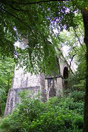
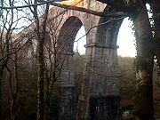
. The viaduct crosses the Luxulyan Valley
Luxulyan Valley
The Luxulyan Valley is the steep sided and thickly wooded valley of the River Par, situated in the south east of Cornwall, England. It contains a major concentration of early 19th century industrial remains, and was designated as part of a World Heritage Site in 2006.The valley stretches south-east...
, and with it forms an integral part of the Cornwall and West Devon Mining Landscape, a World Heritage Site
World Heritage Site
A UNESCO World Heritage Site is a place that is listed by the UNESCO as of special cultural or physical significance...
.
History
In 1813, Joseph AustenJoseph Treffry
Joseph Austen Treffry was an engineer, mining adventurer, and industrialist who became a significant landowner in Cornwall, United Kingdom.-Biography:...
inherited the estates of the Treffry family on the death of his mother's brother (he changed his name to Treffry in 1838). He began to develop the assets, particularly the mineral wealth, and saw that the Luxulyan Valley was a convenient route between the south coast and the high ground in central Cornwall. He built a new artificial harbour, completed in 1829, at Par
Par, Cornwall
Par is a town and fishing port with a harbour on the south coast of Cornwall, England, United Kingdom. The town is situated in the civil parish of Tywardreath and Par and is approximately east of St Austell. Par has a population of around 1,400.....
, a canal up the valley to Ponts Mill and an inclined plane railway
Cable railway
A cable railway is a steeply graded railway that uses a cable or rope to haul trains.-Introduction:...
to the Fowey Consols mine
Fowey Consols mine
Fowey Consols mine is a group of mines in the St Blazey district of Cornwall. They were owned by wealthy Cornishman, Joseph Treffry. The mines were worked by 6 steam engines and 17 waterwheels. The mines were linked to the port at Par by a canal...
on Penpillick Hill. To bring water power to the mine he built a leat
Leat
A leat is the name, common in the south and west of England and in Wales, for an artificial watercourse or aqueduct dug into the ground, especially one supplying water to a watermill or its mill pond...
from Luxulyan along the west side of the valley. He also acquired the moribund port of Newquay
Newquay
Newquay is a town, civil parish, seaside resort and fishing port in Cornwall, England. It is situated on the North Atlantic coast of Cornwall approximately west of Bodmin and north of Truro....
and land and mines in the area of Goss Moor
Goss Moor NNR
Goss Moor is a National Nature Reserve in Cornwall, located in the parishes of St. Dennis, St. Columb Major, Roche and St. Enoder. It is the largest continuous mire complex in South-West Britain and consists of mainly Peatland and Lowland Heath...
, and planned to link them by a railway system.
Work began in 1835 on a tramway
Tramway (mineral)
Tramways are lightly laid railways, sometimes worked without locomotives. The term is in common use in the United Kingdom, New Zealand, and elsewhere. In New Zealand, they are commonly known as bush tramways...
up the valley, but Austen and his steward William Pease realised that it was not going to meet their ambitions, so it was abandoned and only a few fragments of the route are visible today. Instead, they built a much larger-scale tramway, with the inclined plane from the canal basin, past the Carmears Rocks, to the level of the top of the valley, then a level run through Luxulyan and on to its terminus at the Bugle Inn near Mollinis
Bugle, Cornwall
Bugle is a village in central Cornwall, United Kingdom. It is in the parish of Treverbyn and is situated about five miles north of St Austell on the A391 road....
. This required a high-level crossing of the river, for which they built the great viaduct, 650 feet (198 m) long and 100 feet (30 m) high, the most advanced engineering project in the western peninsula. It was built of stone from the Carbeans and Colcerrow quarries, and the lines from the quarries to the viaduct were the first parts of the tramway to be operational. The tramway was completed in 1844.
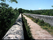
The viaduct carried both rails and a water channel to bring more water for the Fowey Consols, and this is where the quality of the design and construction becomes apparent. The level of a waterway must be precisely correct, or the water will not flow.
On its way down, the water was used to power the Carmears incline, by means of a water wheel
Water wheel
A water wheel is a machine for converting the energy of free-flowing or falling water into useful forms of power. A water wheel consists of a large wooden or metal wheel, with a number of blades or buckets arranged on the outside rim forming the driving surface...
, 34 feet (10 m) in diameter. This enabled the tramway to work loads up the incline, against gravity.
The last improvement Joseph Treffry made was a continuation of the railway alongside the canal to Par Harbour, but this was not completed until after his untimely death in 1850.
Two more granite quarries were at work within the Valley, Rock Mill and Orchard. In 1870 the South Cornwall Granite company opened a railway linking these to Ponts Mill. This is what we now call the Valley Floor Tramway - the Treffry era railways, all horse-worked, were later called tramways to distinguish them from later locomotive-powered lines. The quarries were worked until about 1928; the last stone came from Carbeans in 1933 and the last of Treffry's rails were removed in 1940.
In 1872 a group of London businessmen began a massive rebuild of Treffry's tramways to enable them to exploit the ironstone deposits near Newquay. They constructed a new route through the Valley, which left the old one below Ponts Mill, ascended the west side of the Valley, crossed the Par River twice on the Ponts Mill and Rock Mill Viaducts, passed under the Treffry Viaduct, approached Luxulyan through a tunnel and rejoined the old route at Luxulyan railway station
Luxulyan railway station
Luxulyan railway station is located in the parish of Luxulyan in central Cornwall, England. It is one of the stations on the Atlantic Coast Line.-History:...
. The new consortium was called the Cornwall Minerals Railway
Cornwall Minerals Railway
The Cornwall Minerals Railway operated a network of railway lines in Cornwall, United Kingdom. Based at St Blazey, its network stretched from Fowey to Newquay and lasted as an independent company from 1874 to 1896, after which it became a part of the Great Western Railway.-Authorisation:The...
.
Visiting
It is free to visit the viaduct and open all year round. You can walk across and it can be viewed from across the valley.There is car parking at the bottom of the valley at Ponts Mill which is just off the A390 road
A390 road
The A390 is a road in Cornwall and Devon, England. It runs from Tavistock to north west of the city of Truro. Starting in Tavistock, it heads south-westwards towards Liskeard, crossing over the River Tamar and into Cornwall, then through Gunnislake and Callington. Immediately before Liskeard, it...
at Porcupine, or at the top of the valley just north of the Treffry Viaduct, where there is a junction. There are also many walks to the viaduct from St Blazey
St Blazey
St Blazey is a small town in Cornwall, United Kingdom.St Blaise is the civil parish in which St Blazey is situated; the name St Blaise is also used by the town council.St Blazey is situated east of St Austell...
village and from Luxulyan railway station
Luxulyan railway station
Luxulyan railway station is located in the parish of Luxulyan in central Cornwall, England. It is one of the stations on the Atlantic Coast Line.-History:...
on the Newquay branch line
Atlantic Coast Line, Cornwall
The Atlantic Coast Line is a community railway line in Cornwall, United Kingdom. The line runs from the English Channel at Par, to the Atlantic Ocean at Newquay.-Route:The Atlantic Coast Line starts from Par station, in the village and port of Par...
.
Film and television
The BBCBBC
The British Broadcasting Corporation is a British public service broadcaster. Its headquarters is at Broadcasting House in the City of Westminster, London. It is the largest broadcaster in the world, with about 23,000 staff...
television programme Seven Man Made Wonders, which was broadcast in 2006, featured the viaduct.
The viaduct was used as a location in the film Omen III: The Final Conflict
Omen III: The Final Conflict
Omen III: The Final Conflict is a 1981 British/American horror film directed by Graham Baker and the third installment in The Omen series...
.