
Toutle River Sediment Retention Structure
Encyclopedia
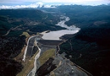
The Sediment Retention Structure is a 1800 feet (548.6 m), 184 feet (56.1 m) earthen dam on the North Fork of the Toutle River
in Washington. Its construction was completed by the US Army Corps of Engineers in 1989. Its purpose is to retain sediment
created since the 1980 eruption of Mount St. Helens
, to prevent the sediment from becoming a hazard to navigation on the Toutle
, Cowlitz
and Columbia River
s.
The Corps of Engineers expects the lake behind the dam to be completely filled with sediment by 2035 with 258 million cubic yards (197 million m3) of sand, gravel and sediment. However, the basin is already filled as of 2011.
Toutle River
The Toutle River is a river in southwestern Washington State, in the Pacific Northwest region of the United States. It rises in two forks on the flanks of Mount St. Helens and joins the Cowlitz River near Castle Rock.-Eruption of Mount St. Helens:...
in Washington. Its construction was completed by the US Army Corps of Engineers in 1989. Its purpose is to retain sediment
Sediment
Sediment is naturally occurring material that is broken down by processes of weathering and erosion, and is subsequently transported by the action of fluids such as wind, water, or ice, and/or by the force of gravity acting on the particle itself....
created since the 1980 eruption of Mount St. Helens
1980 eruption of Mount St. Helens
The 1980 eruption of Mount St. Helens, a stratovolcano located in Washington state, in the United States, was a major volcanic eruption. The eruption was the only significant one to occur in the contiguous 48 U.S. states since the 1915 eruption of Lassen Peak in California...
, to prevent the sediment from becoming a hazard to navigation on the Toutle
Toutle River
The Toutle River is a river in southwestern Washington State, in the Pacific Northwest region of the United States. It rises in two forks on the flanks of Mount St. Helens and joins the Cowlitz River near Castle Rock.-Eruption of Mount St. Helens:...
, Cowlitz
Cowlitz River
The Cowlitz River is a river in the state of Washington in the United States, a tributary of the Columbia River. Its tributaries drain a large region including the slopes of Mount Rainier, Mount Adams, and Mount St. Helens....
and Columbia River
Columbia River
The Columbia River is the largest river in the Pacific Northwest region of North America. The river rises in the Rocky Mountains of British Columbia, Canada, flows northwest and then south into the U.S. state of Washington, then turns west to form most of the border between Washington and the state...
s.
The Corps of Engineers expects the lake behind the dam to be completely filled with sediment by 2035 with 258 million cubic yards (197 million m3) of sand, gravel and sediment. However, the basin is already filled as of 2011.
External links
- Sediment Retention Structure, US Army Corps of Engineers, Portland District