
Cowlitz River
Encyclopedia
The Cowlitz River is a river
in the state of Washington in the United States
, a tributary
of the Columbia River
. Its tributaries drain a large region including the slopes of Mount Rainier
, Mount Adams
, and Mount St. Helens
.
The Cowlitz has a 2586 square miles (6,698 km²) drainage basin
, located between the Cascade Range
in eastern Lewis County, Washington
and the cities of Kelso
and Longview
. The river is roughly 105 miles (169 km) long, not counting tributaries.
Major tributaries of the Cowlitz River include the Cispus River
and the Toutle River
, which was overtaken by volcanic mudflows (lahar
s) during the May 1980 eruption of Mount St. Helens
.
, with several small-scale hydropower
and sediment retention structures within the Cowlitz Basin.
The Cowlitz Falls Project is a 70 megawatt hydroelectric
dam that was constructed in the early 1990s and completed in 1994. The dam is 140 feet (42.7 m) high and 700 feet (213.4 m) wide. The Cowlitz Falls Project produces on average 260 gigawatthours annually for Lewis County PUD. Its reservoir, Lake Scanewa, is located at the confluence of the Cowlitz and Cispus Rivers downstream of Randle
.
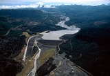
Mossyrock Dam
began generating power for Tacoma City Light in 1968. It rises 605 feet (184.4 m) from bedrock and created 23 miles (37 km) long Riffe Lake
(previously Davisson Reservoir). It is the highest dam in the Pacific Northwest. The dam is named for the nearby city of Mossyrock
, and the lake for the town of Riffe, which, along with Kosmos, was destroyed by the flooding of the Cowlitz River valley above the dam.
The Mayfield Dam is 850 feet (259.1 m) long and 185 feet (56.4 m) high. An 860 feet (262.1 m) tunnel connects the reservoir to the powerhouse. The dam began producing electricity in 1963. Mayfield Lake offers many recreational opportunities due to the presence of several county and state parks and its location below the Mossyrock Dam. The modulated inflow from the Mossyrock Dam allows Mayfield Lake to maintain a water level that rarely fluctuates more than a few feet. It is located several miles downstream of Mossyrock.
Packwood Lake was dammed in 1964 by the Washington Public Power Supply System (now called Energy Northwest). As an ancient landslide used to, the dam supplanted the job of holding back the lake, redirecting streamflow to a 27 megawatt hydroelectric generator in the Cowlitz River valley floor 2,000 feet (300 m) below just outside the town of Packwood
. When designing and building the dam, care was taken so as not to affect the abundant wildlife that calls the lake and surrounding area home; the dam raising the water level by only a few feet.
 A serious side effect of the Mount St. Helens
1980 eruption has been the downstream movement of enormous amounts of sediment through the North Fork Toutle River
. After the eruption, river-borne sediment increased over five thousand-fold, making the Toutle River one of the most sediment-laden rivers in the world. The Toutle River Sediment Retention Structure
was constructed to trap this sediment before it was carried farther downstream, where it could clog the river channel, exacerbate floods along the lower Toutle and Cowlitz Rivers, and fill the Columbia River
shipping channel, which still requires periodic dredging. An overflow channel has been added to divert lahar
s around the dam.
Just upstream from its mouth at the Columbia river, a railroad bridge connecting the Port of Longview to the BNSF rail line crosses the Cowlitz, with a road bridge for SR 432 (Tennant Way) beside.
Further upstream are the Allen St. and Cowlitz Way bridges, connecting West Kelso with the rest of Kelso
. Just north of Kelso, a railroad bridge provides crossing for the Columbia & Cowlitz Railroad
.
Connecting SR 411 to Interstate-5 is the Lexington bridge, a two lane bridge between the large unincorporated community of Lexington to Exit 42 on the east side of the bank.
At Castle Rock
, the A St. bridge provides access from downtown to the school and residential areas across the river. A few miles north, after the Toutle River split, the BNSF line crosses the river.
Across the Lewis
/Cowlitz County
line, between the towns of Vader
and Toledo, Washington
, I-5
crosses the river. At Toledo
, SR-505 (called the Jackson Highway) crosses.
Where Highway 12
crosses Mayfield Lake, just west of Mossyrock, causeways were built out to the middle of the lake, where a short bridge section connects the two sides. A small bridge provides a crossing for SR 122 at the head of Mayfield Lake. Just east of Mossyrock, the Cowlitz River Bridge on Highway 12 was the largest concrete arch bridge in North America until 1971 at 550 feet (167.6 m).
At the head of Riffe Lake, the 27 Road provides access to the forestland south of the Cowlitz from Morton
and Glenoma
to the north.
At Randle
, SR 131 crosses the Cowlitz to provide access to the Cispus basin and the northern areas of the Mount St. Helens National Volcanic Monument
.
Between Randle and Packwood, Highway 12 crosses the Cowlitz at the Cora bridge.
At Packwood, Skate Creek Road spans the river, providing access to the Gifford Pinchot National Forest
and Tatoosh Wilderness
, as well as connecting the downtown and residential areas of Packwood.
Upstream from Packwood, the Cowlitz splits into the Muddy and Clear Forks, with several Forest Service and Park Service roads crossing each.
The Bonneville Power Administration
, in cooperation with the Lewis County PUD, state and federal agencies and Tacoma Power, constructed a downstream anadromous fish collection facility as part of the Cowlitz Falls Project. The fish facility, along with the Cowlitz River Salmon Hatchery's diversion dam below Mayfield Lake, has permitted the reintroduction of salmon and steelhead in the upper Cowlitz River basin for the first time since the construction of the Mossyrock and Mayfield dams in the 1960s.
Steelhead and Salmon Fishing Trips can be arranged through several local fishing guides.
River
A river is a natural watercourse, usually freshwater, flowing towards an ocean, a lake, a sea, or another river. In a few cases, a river simply flows into the ground or dries up completely before reaching another body of water. Small rivers may also be called by several other names, including...
in the state of Washington in the United States
United States
The United States of America is a federal constitutional republic comprising fifty states and a federal district...
, a tributary
Tributary
A tributary or affluent is a stream or river that flows into a main stem river or a lake. A tributary does not flow directly into a sea or ocean...
of the Columbia River
Columbia River
The Columbia River is the largest river in the Pacific Northwest region of North America. The river rises in the Rocky Mountains of British Columbia, Canada, flows northwest and then south into the U.S. state of Washington, then turns west to form most of the border between Washington and the state...
. Its tributaries drain a large region including the slopes of Mount Rainier
Mount Rainier
Mount Rainier is a massive stratovolcano located southeast of Seattle in the state of Washington, United States. It is the most topographically prominent mountain in the contiguous United States and the Cascade Volcanic Arc, with a summit elevation of . Mt. Rainier is considered one of the most...
, Mount Adams
Mount Adams (Washington)
Mount Adams is a potentially activestratovolcano in the Cascade Range and the second-highest mountain in the U.S. state of Washington.Adams is a member of the Cascade Volcanic Arc, and is one of the arc's largest volcanoes,...
, and Mount St. Helens
Mount St. Helens
Mount St. Helens is an active stratovolcano located in Skamania County, Washington, in the Pacific Northwest region of the United States. It is south of Seattle, Washington and northeast of Portland, Oregon. Mount St. Helens takes its English name from the British diplomat Lord St Helens, a...
.
The Cowlitz has a 2586 square miles (6,698 km²) drainage basin
Drainage basin
A drainage basin is an extent or an area of land where surface water from rain and melting snow or ice converges to a single point, usually the exit of the basin, where the waters join another waterbody, such as a river, lake, reservoir, estuary, wetland, sea, or ocean...
, located between the Cascade Range
Cascade Range
The Cascade Range is a major mountain range of western North America, extending from southern British Columbia through Washington and Oregon to Northern California. It includes both non-volcanic mountains, such as the North Cascades, and the notable volcanoes known as the High Cascades...
in eastern Lewis County, Washington
Lewis County, Washington
Lewis County is a county located in the U.S. state of Washington. As of 2010, the population was 75,455. The county seat is at Chehalis, and its largest city is Centralia....
and the cities of Kelso
Kelso, Washington
Kelso is a city in southwest Washington State, United States, and is the county seat of Cowlitz County. At the 2010 census, the population was 11,925. Kelso is part of the Longview, Washington Metropolitan Statistical Area, which has a population of 102,410. Kelso shares its long western border...
and Longview
Longview, Washington
Longview is a city in Cowlitz County, Washington, United States. It is the principal city of the "Longview, Washington Metropolitan Statistical Area", which encompasses all of Cowlitz County. Longview's population was 36,648 at the time of the 2010 census and is the largest city in Cowlitz County...
. The river is roughly 105 miles (169 km) long, not counting tributaries.
Major tributaries of the Cowlitz River include the Cispus River
Cispus River
The Cispus River is approximately 53 miles in length and flows into the Cowlitz River at Lake Scanewa in the Cascade Mountains of Washington. Its tributaries drain most of south-central and southeastern Lewis County, extreme northeast Skamania County, and some of western Yakima County.Its main...
and the Toutle River
Toutle River
The Toutle River is a river in southwestern Washington State, in the Pacific Northwest region of the United States. It rises in two forks on the flanks of Mount St. Helens and joins the Cowlitz River near Castle Rock.-Eruption of Mount St. Helens:...
, which was overtaken by volcanic mudflows (lahar
Lahar
A lahar is a type of mudflow or debris flow composed of a slurry of pyroclastic material, rocky debris, and water. The material flows down from a volcano, typically along a river valley. The term is a shortened version of "berlahar" which originated in the Javanese language of...
s) during the May 1980 eruption of Mount St. Helens
Mount St. Helens
Mount St. Helens is an active stratovolcano located in Skamania County, Washington, in the Pacific Northwest region of the United States. It is south of Seattle, Washington and northeast of Portland, Oregon. Mount St. Helens takes its English name from the British diplomat Lord St Helens, a...
.
Dams
The Cowlitz River currently has 3 major hydroelectric damsHydroelectricity
Hydroelectricity is the term referring to electricity generated by hydropower; the production of electrical power through the use of the gravitational force of falling or flowing water. It is the most widely used form of renewable energy...
, with several small-scale hydropower
Hydroelectricity
Hydroelectricity is the term referring to electricity generated by hydropower; the production of electrical power through the use of the gravitational force of falling or flowing water. It is the most widely used form of renewable energy...
and sediment retention structures within the Cowlitz Basin.
The Cowlitz Falls Project is a 70 megawatt hydroelectric
Hydroelectricity
Hydroelectricity is the term referring to electricity generated by hydropower; the production of electrical power through the use of the gravitational force of falling or flowing water. It is the most widely used form of renewable energy...
dam that was constructed in the early 1990s and completed in 1994. The dam is 140 feet (42.7 m) high and 700 feet (213.4 m) wide. The Cowlitz Falls Project produces on average 260 gigawatthours annually for Lewis County PUD. Its reservoir, Lake Scanewa, is located at the confluence of the Cowlitz and Cispus Rivers downstream of Randle
Randle, Washington
Randle is an unincorporated community in extreme eastern Lewis County, Washington, United States. Randle is located on U.S. Route 12 and is notable as the northeastern access point to the Mount St. Helens Windy Ridge viewpoint, by way of forest service roads that cut through the Gifford Pinchot...
.
Mossyrock Dam
Mossyrock Dam
Mossyrock Dam is a concrete arch-gravity dam on the Cowlitz River near Mossyrock in Lewis County, Washington. The reservoir created by the dam is called Riffe Lake and the primary purpose of the dam is hydroelectric production while flood control is secondary...
began generating power for Tacoma City Light in 1968. It rises 605 feet (184.4 m) from bedrock and created 23 miles (37 km) long Riffe Lake
Riffe Lake
Riffe Lake is a long reservoir on the Cowlitz River in the U.S. state of Washington. Originally named Davisson Lake, it was created in 1968 with the construction of Mossyrock Dam. The lake was renamed in 1976 after the community of Riffe, which was inundated by the lake....
(previously Davisson Reservoir). It is the highest dam in the Pacific Northwest. The dam is named for the nearby city of Mossyrock
Mossyrock, Washington
Mossyrock is a city in Lewis County, Washington, United States. The population was 759 at the 2010 census.-History:The city began as a trading post named Mossy Rock in 1852, after a high moss-covered rock at the east end of Klickitat Prairie...
, and the lake for the town of Riffe, which, along with Kosmos, was destroyed by the flooding of the Cowlitz River valley above the dam.
The Mayfield Dam is 850 feet (259.1 m) long and 185 feet (56.4 m) high. An 860 feet (262.1 m) tunnel connects the reservoir to the powerhouse. The dam began producing electricity in 1963. Mayfield Lake offers many recreational opportunities due to the presence of several county and state parks and its location below the Mossyrock Dam. The modulated inflow from the Mossyrock Dam allows Mayfield Lake to maintain a water level that rarely fluctuates more than a few feet. It is located several miles downstream of Mossyrock.
Packwood Lake was dammed in 1964 by the Washington Public Power Supply System (now called Energy Northwest). As an ancient landslide used to, the dam supplanted the job of holding back the lake, redirecting streamflow to a 27 megawatt hydroelectric generator in the Cowlitz River valley floor 2,000 feet (300 m) below just outside the town of Packwood
Packwood, Washington
Packwood is an unincorporated community located in easternmost Lewis County, Washington.Packwood is located at the intersection of US Highway 12 and Gifford Pinchot National Forest Road 52 . It is located between Mount Rainier National Park to the north and Mt. St. Helens National Volcanic Monument...
. When designing and building the dam, care was taken so as not to affect the abundant wildlife that calls the lake and surrounding area home; the dam raising the water level by only a few feet.
Mount St. Helens
Mount St. Helens is an active stratovolcano located in Skamania County, Washington, in the Pacific Northwest region of the United States. It is south of Seattle, Washington and northeast of Portland, Oregon. Mount St. Helens takes its English name from the British diplomat Lord St Helens, a...
1980 eruption has been the downstream movement of enormous amounts of sediment through the North Fork Toutle River
North Fork Toutle River
The North Fork Toutle River is a tributary of the Toutle River in the southwestern Washington in the United States. The river has its headwaters near Spirit Lake, on the north side of Mount St. Helens, and flows about to the Toutle River, upstream of its confluence with the Columbia River...
. After the eruption, river-borne sediment increased over five thousand-fold, making the Toutle River one of the most sediment-laden rivers in the world. The Toutle River Sediment Retention Structure
Toutle River Sediment Retention Structure
The Sediment Retention Structure is a , earthen dam on the North Fork of the Toutle River in Washington. Its construction was completed by the US Army Corps of Engineers in 1989. Its purpose is to retain sediment created since the 1980 eruption of Mount St...
was constructed to trap this sediment before it was carried farther downstream, where it could clog the river channel, exacerbate floods along the lower Toutle and Cowlitz Rivers, and fill the Columbia River
Columbia River
The Columbia River is the largest river in the Pacific Northwest region of North America. The river rises in the Rocky Mountains of British Columbia, Canada, flows northwest and then south into the U.S. state of Washington, then turns west to form most of the border between Washington and the state...
shipping channel, which still requires periodic dredging. An overflow channel has been added to divert lahar
Lahar
A lahar is a type of mudflow or debris flow composed of a slurry of pyroclastic material, rocky debris, and water. The material flows down from a volcano, typically along a river valley. The term is a shortened version of "berlahar" which originated in the Javanese language of...
s around the dam.
Bridges
The Cowlitz is spanned by several bridges along its length.Just upstream from its mouth at the Columbia river, a railroad bridge connecting the Port of Longview to the BNSF rail line crosses the Cowlitz, with a road bridge for SR 432 (Tennant Way) beside.
Further upstream are the Allen St. and Cowlitz Way bridges, connecting West Kelso with the rest of Kelso
Kelso, Washington
Kelso is a city in southwest Washington State, United States, and is the county seat of Cowlitz County. At the 2010 census, the population was 11,925. Kelso is part of the Longview, Washington Metropolitan Statistical Area, which has a population of 102,410. Kelso shares its long western border...
. Just north of Kelso, a railroad bridge provides crossing for the Columbia & Cowlitz Railroad
Columbia and Cowlitz Railway
The Columbia and Cowlitz Railway , is a wholly owned subsidiary of Weyerhaeuser Company, and is headquartered in Longview, Washington; the railroad serves an route from the Weyerhaeuser Company mill in Longview to the junction just outside the city limits of Kelso...
.
Connecting SR 411 to Interstate-5 is the Lexington bridge, a two lane bridge between the large unincorporated community of Lexington to Exit 42 on the east side of the bank.
At Castle Rock
Castle Rock, Washington
Castle Rock is a city in Cowlitz County, Washington, United States. Nestled between the Willapa Hills and western base of Mount St. Helens, Castle Rock is at the heart of Washington timber country in the Pacific temperate rain forest...
, the A St. bridge provides access from downtown to the school and residential areas across the river. A few miles north, after the Toutle River split, the BNSF line crosses the river.
Across the Lewis
Lewis County, Washington
Lewis County is a county located in the U.S. state of Washington. As of 2010, the population was 75,455. The county seat is at Chehalis, and its largest city is Centralia....
/Cowlitz County
Cowlitz County, Washington
Cowlitz County is a county located in the U.S. state of Washington. As of the 2010 census its population was 102,410. It forms the Longview, Washington, Metropolitan Statistical Area which encompasses all of Cowlitz County. The county seat is at Kelso, and its largest city is Longview...
line, between the towns of Vader
Vader, Washington
Vader is a city in Lewis County, Washington, United States. The population was 621 at the 2010 census.-History:Vader was originally named Little Falls and incorporated as such on January 12, 1906. The name was changed to Sopenah by the Northern Pacific Railway because there was already a Little...
and Toledo, Washington
Toledo, Washington
Toledo is a city in Lewis County, Washington, United States. The population was 725 at the 2010 census.-History:Toledo was officially incorporated on October 10, 1892. Toledo was named by Celeste Rochon after a pioneer side wheel paddle steamer operated by Captain Oren Kellogg of the Kellogg...
, I-5
Interstate 5
Interstate 5 is the main Interstate Highway on the West Coast of the United States, running largely parallel to the Pacific Ocean coastline from Canada to Mexico . It serves some of the largest cities on the U.S...
crosses the river. At Toledo
Toledo, Washington
Toledo is a city in Lewis County, Washington, United States. The population was 725 at the 2010 census.-History:Toledo was officially incorporated on October 10, 1892. Toledo was named by Celeste Rochon after a pioneer side wheel paddle steamer operated by Captain Oren Kellogg of the Kellogg...
, SR-505 (called the Jackson Highway) crosses.
Where Highway 12
U.S. Route 12
U.S. Route 12 or US 12 is an east–west United States highway, running from Grays Harbor on the Pacific Ocean, in the state of Washington, to downtown Detroit, for almost . As a thoroughfare, it has mostly been supplanted by I-90 and I-94, but remains an important road for local travel.The...
crosses Mayfield Lake, just west of Mossyrock, causeways were built out to the middle of the lake, where a short bridge section connects the two sides. A small bridge provides a crossing for SR 122 at the head of Mayfield Lake. Just east of Mossyrock, the Cowlitz River Bridge on Highway 12 was the largest concrete arch bridge in North America until 1971 at 550 feet (167.6 m).
At the head of Riffe Lake, the 27 Road provides access to the forestland south of the Cowlitz from Morton
Morton, Washington
Morton is a city in Lewis County, Washington, United States. The population was 1,126 at the 2010 census.-History:Morton was first settled in 1871 by James Fletcher. It was later named after Benjamin Harrison's Vice President, Levi P. Morton, in 1889. Morton was officially incorporated on January...
and Glenoma
Glenoma, Washington
Glenoma is a small unincorporated town in Lewis County, Washington, United States. It derives its name from the words "glen" and "ome" ....
to the north.
At Randle
Randle, Washington
Randle is an unincorporated community in extreme eastern Lewis County, Washington, United States. Randle is located on U.S. Route 12 and is notable as the northeastern access point to the Mount St. Helens Windy Ridge viewpoint, by way of forest service roads that cut through the Gifford Pinchot...
, SR 131 crosses the Cowlitz to provide access to the Cispus basin and the northern areas of the Mount St. Helens National Volcanic Monument
Mount St. Helens National Volcanic Monument
Mount St. Helens National Volcanic Monument is a U.S. National Monument that includes the area around Mount St. Helens in Washington. It was established on August 27, 1982 by U.S. President Ronald Reagan following the 1980 eruption of Mount St. Helens. The 110,000 acre National Volcanic...
.
Between Randle and Packwood, Highway 12 crosses the Cowlitz at the Cora bridge.
At Packwood, Skate Creek Road spans the river, providing access to the Gifford Pinchot National Forest
Gifford Pinchot National Forest
Gifford Pinchot National Forest is a U.S. National Forest located in southern Washington, USA. With an area of 1.37 million acres , it extends 116 km along the western slopes of Cascade Range from Mount Rainier National Park to the Columbia River. It includes the 110,000 acre Mount St....
and Tatoosh Wilderness
Tatoosh Wilderness
The Tatoosh Wilderness, located in Washington, in the Pacific Northwest region of the United States, is managed by the U.S. Forest Service and protects . In 1984 it was officially designated as wilderness by Congress....
, as well as connecting the downtown and residential areas of Packwood.
Upstream from Packwood, the Cowlitz splits into the Muddy and Clear Forks, with several Forest Service and Park Service roads crossing each.
Other river structures
When the Cowlitz Salmon Hatchery began operation in 1968, it was the largest salmon hatchery in the world. Currently, it produces nearly 13 million fish each year. Adjacent to the salmon hatchery is the barrier dam, which diverts spawning and upriver migrating fish to a separating station where fish are sorted by species. Some of the fish are used by the hatchery while others are transported upstream to continue migration.The Bonneville Power Administration
Bonneville Power Administration
The Bonneville Power Administration is an American federal agency based in the Pacific Northwest. BPA was created by an act of Congress in 1937 to market electric power from the Bonneville Dam located on the Columbia River and to construct facilities necessary to transmit that power...
, in cooperation with the Lewis County PUD, state and federal agencies and Tacoma Power, constructed a downstream anadromous fish collection facility as part of the Cowlitz Falls Project. The fish facility, along with the Cowlitz River Salmon Hatchery's diversion dam below Mayfield Lake, has permitted the reintroduction of salmon and steelhead in the upper Cowlitz River basin for the first time since the construction of the Mossyrock and Mayfield dams in the 1960s.
Main tributaries
- Ohanapecosh RiverOhanapecosh RiverThe Ohanapecosh River is a river in the U.S. state of Washington.It is the main headwater tributary of the Cowlitz River, which begins at the confluence of the Ohanapecosh River and the Clear Fork Cowlitz River. The Ohanapecosh originates near Ohanapecosh Glacier on the southeast side of Mount...
- Lake Creek
- Johnson Creek
- Cispus RiverCispus RiverThe Cispus River is approximately 53 miles in length and flows into the Cowlitz River at Lake Scanewa in the Cascade Mountains of Washington. Its tributaries drain most of south-central and southeastern Lewis County, extreme northeast Skamania County, and some of western Yakima County.Its main...
- Tilton RiverTilton RiverThe Tilton River is a tributary of the Cowlitz River, in the U.S. state of Washington. Named for territorial surveyor James Tilton, its entire course is contained in Lewis County, Washington.-Course:...
- Sulphur Creek
- Winston Creek
- Lacamas Creek
- Olequa Creek
- Toutle RiverToutle RiverThe Toutle River is a river in southwestern Washington State, in the Pacific Northwest region of the United States. It rises in two forks on the flanks of Mount St. Helens and joins the Cowlitz River near Castle Rock.-Eruption of Mount St. Helens:...
- Coweeman RiverCoweeman RiverThe Coweeman River is a tributary of the Cowlitz River, in the U.S. state of Washington. Its name comes from the Cowlitz word ko-wee-na, meaning "short one", referring to a short Indian who once lived along the river.-Course:...
Recreation
These two hatcheries provide an exceptional sportfishing opportunity for recreational anglers in Washington and Oregon. The Cowlitz river consistently ranks as one of the states top ten steelhead and salmon producers.Steelhead and Salmon Fishing Trips can be arranged through several local fishing guides.