

Toubkal
Encyclopedia
Toubkal is a mountain
peak in southwestern Morocco
, located in the Toubkal National Park
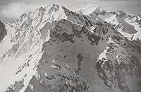
. At 4,167 metres, it is the highest peak in the Atlas Mountains
and in North Africa
. It is located 63 km south of the city of Marrakesh, in the Toubkal National Park. The first ascent by Europeans was on 12 June 1923 by the Marquis de Segonzac, Vincent Berger and Hubert Dolbeau, but the mountain may have been climbed before that date.
 Trekkers usually approach the mountain from the road-end village of Imlil
. Qualified local guides can be hired, as well as mule
s and porters, to carry equipment and food supplies higher into the mountains. For experienced mountaineers, guides are not required for the normal route, as it is an easy hike and orientation is not a problem.
The normal route starts with an easy walk to the village of Aroumd. Past Aroumd a floodplain
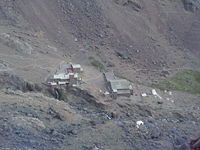
is crossed and the route follows the left slope of the valley southwards. The valley bends to the east to the tiny settlement of Sidi Chamharouch, which has grown around a Muslim shrine. At Sidi Chamharouch, the path leads over the stream and runs steeply uphill to the right side of the Isougouane valley, which leads to two stone-built refuges (old Neltner Refuge and new Refuge du Toubkal) that are often used as base camp at 3207 m (10,522 ft). It is possible to buy good meals in the Refuge du Toubkal. Tents can be pitched near the refuges for a small charge.
From that point a path crosses the stream, climbs a steep scree
slope to the east and enters a valley (corrie
), then climbs another steep slope to reach a col
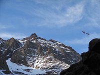
(Tizi'n'Toubkal at 3,940m). At the col the route turns left (northwards) to the summit ridge of Jbel Toubkal. The 4,167m summit is crowned with a curious pyramidal metal frame and views take in most of the Atlas and Little Atlas Mountains.
The ascent during the summer (from May) is non-technical and easy, only complicated by steep and slippery scree slopes and altitude sickness
. Sturdy boots and proper (windproof) clothing are required, and trekking poles
are helpful on the scree. An ice-axe
may be needed on the remaining snowfields in the early summer.
It is possible to climb the mountain in two days - first day up to the refuge (around seven hours without mules), second day to the summit (around five hours) and back to Imlil (up to five hours).
In summer the mountains can be very dry, but are sometimes subject to storms. Although the temperature should remain above zero during the day, freezing conditions are possible over 3,500m. In winter the mountains are covered in snow and ice, and can be prone to avalanches. Skiing is possible as the snow can lie to considerable depth and cover many rocky slopes. Information about state of the route can be obtained at Marrakech tourist offices or at Imlil.

Mountain
Image:Himalaya_annotated.jpg|thumb|right|The Himalayan mountain range with Mount Everestrect 58 14 160 49 Chomo Lonzorect 200 28 335 52 Makalurect 378 24 566 45 Mount Everestrect 188 581 920 656 Tibetan Plateaurect 250 406 340 427 Rong River...
peak in southwestern Morocco
Morocco
Morocco , officially the Kingdom of Morocco , is a country located in North Africa. It has a population of more than 32 million and an area of 710,850 km², and also primarily administers the disputed region of the Western Sahara...
, located in the Toubkal National Park
Toubkal National Park
Toubkal National Park is a national park in the High Atlas mountain range, 70 kilometres from Marrakech in central-western Morocco. Established in 1942, it covers an area of 380 km2...
. At 4,167 metres, it is the highest peak in the Atlas Mountains
Atlas Mountains
The Atlas Mountains is a mountain range across a northern stretch of Africa extending about through Morocco, Algeria, and Tunisia. The highest peak is Toubkal, with an elevation of in southwestern Morocco. The Atlas ranges separate the Mediterranean and Atlantic coastlines from the Sahara Desert...
and in North Africa
North Africa
North Africa or Northern Africa is the northernmost region of the African continent, linked by the Sahara to Sub-Saharan Africa. Geopolitically, the United Nations definition of Northern Africa includes eight countries or territories; Algeria, Egypt, Libya, Morocco, South Sudan, Sudan, Tunisia, and...
. It is located 63 km south of the city of Marrakesh, in the Toubkal National Park. The first ascent by Europeans was on 12 June 1923 by the Marquis de Segonzac, Vincent Berger and Hubert Dolbeau, but the mountain may have been climbed before that date.
Imlil
Imlil is a small village in the high Atlas Mountains of Morocco. It is located 1740 meters above sea level. A portrait of Imlil and the problems and prospects of Morocco's mountain populations appeared in 1984 in the book by James A. Miller called Imlil and published by Westview Press). It is...
. Qualified local guides can be hired, as well as mule
Mule
A mule is the offspring of a male donkey and a female horse. Horses and donkeys are different species, with different numbers of chromosomes. Of the two F1 hybrids between these two species, a mule is easier to obtain than a hinny...
s and porters, to carry equipment and food supplies higher into the mountains. For experienced mountaineers, guides are not required for the normal route, as it is an easy hike and orientation is not a problem.
The normal route starts with an easy walk to the village of Aroumd. Past Aroumd a floodplain
Floodplain
A floodplain, or flood plain, is a flat or nearly flat land adjacent a stream or river that stretches from the banks of its channel to the base of the enclosing valley walls and experiences flooding during periods of high discharge...
is crossed and the route follows the left slope of the valley southwards. The valley bends to the east to the tiny settlement of Sidi Chamharouch, which has grown around a Muslim shrine. At Sidi Chamharouch, the path leads over the stream and runs steeply uphill to the right side of the Isougouane valley, which leads to two stone-built refuges (old Neltner Refuge and new Refuge du Toubkal) that are often used as base camp at 3207 m (10,522 ft). It is possible to buy good meals in the Refuge du Toubkal. Tents can be pitched near the refuges for a small charge.
From that point a path crosses the stream, climbs a steep scree
Scree
Scree, also called talus, is a term given to an accumulation of broken rock fragments at the base of crags, mountain cliffs, or valley shoulders. Landforms associated with these materials are sometimes called scree slopes or talus piles...
slope to the east and enters a valley (corrie
Cirque
Cirque may refer to:* Cirque, a geological formation* Makhtesh, an erosional landform found in the Negev desert of Israel and Sinai of Egypt*Cirque , an album by Biosphere* Cirque Corporation, a company that makes touchpads...
), then climbs another steep slope to reach a col
Mountain pass
A mountain pass is a route through a mountain range or over a ridge. If following the lowest possible route, a pass is locally the highest point on that route...
(Tizi'n'Toubkal at 3,940m). At the col the route turns left (northwards) to the summit ridge of Jbel Toubkal. The 4,167m summit is crowned with a curious pyramidal metal frame and views take in most of the Atlas and Little Atlas Mountains.
The ascent during the summer (from May) is non-technical and easy, only complicated by steep and slippery scree slopes and altitude sickness
Altitude sickness
Altitude sickness—also known as acute mountain sickness , altitude illness, hypobaropathy, or soroche—is a pathological effect of high altitude on humans, caused by acute exposure to low partial pressure of oxygen at high altitude...
. Sturdy boots and proper (windproof) clothing are required, and trekking poles
Trekking poles
Trekking poles are a common hiking accessory used to assist walkers with their rhythm and provide stability on rough terrain.-Description:...
are helpful on the scree. An ice-axe
Ice axe
An ice axe, is a multi-purpose ice and snow tool used by mountaineers both in the ascent and descent of routes which involve frozen conditions. It can be held and employed in a number of different ways, depending on the terrain encountered...
may be needed on the remaining snowfields in the early summer.
It is possible to climb the mountain in two days - first day up to the refuge (around seven hours without mules), second day to the summit (around five hours) and back to Imlil (up to five hours).
In summer the mountains can be very dry, but are sometimes subject to storms. Although the temperature should remain above zero during the day, freezing conditions are possible over 3,500m. In winter the mountains are covered in snow and ice, and can be prone to avalanches. Skiing is possible as the snow can lie to considerable depth and cover many rocky slopes. Information about state of the route can be obtained at Marrakech tourist offices or at Imlil.
External links
- More info about Mount Toubkal
- Routes up Mount Toubkal
- The tourist website of Aroumd, also spelt Armed
- Summitpost.org page about Jbel Toubkal
- Satellite picture by Google Maps
- Photo Gallery of climbing Toubkal in winter
- Photo Gallery of Jebel Toubkal and the High Atlas
- Photo Gallery of climbing Toubkal and other travels in Morocco
- Charity Event Climb for Acorns Childrens Hospice, UK